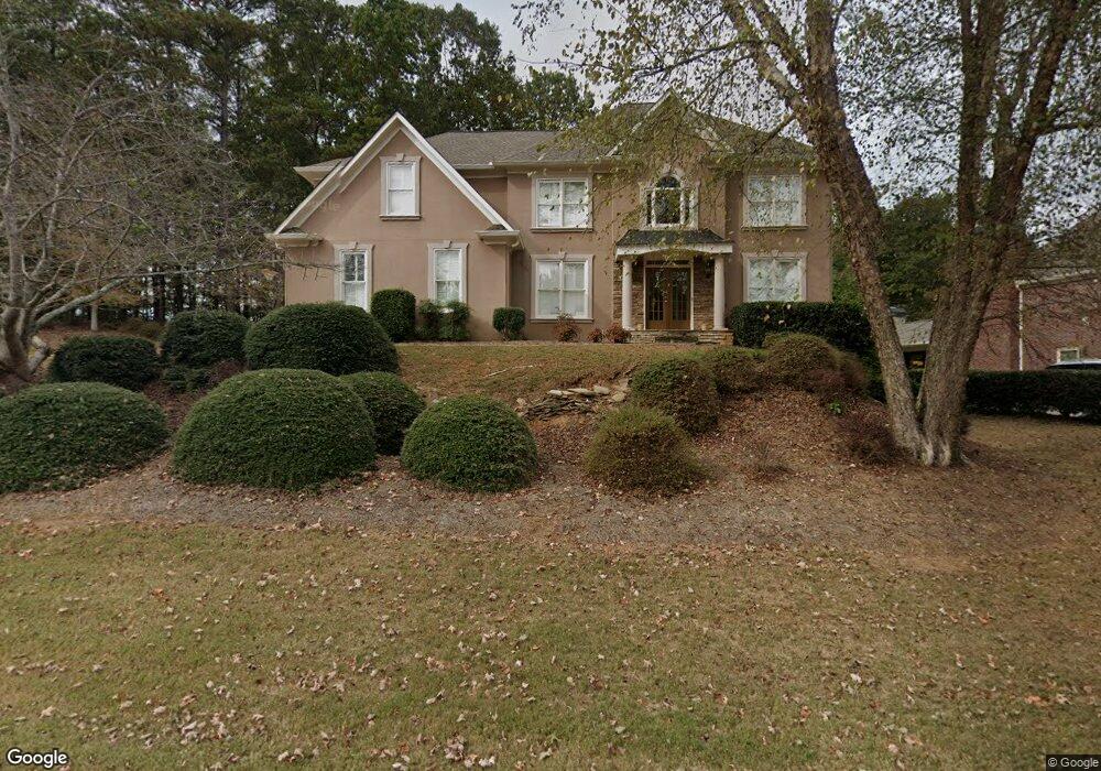
635 Goldpoint Trace Unit 9/390 Woodstock, GA 30189
Oak Grove NeighborhoodEstimated Value: $732,440 - $753,000
6
Beds
4
Baths
5,749
Sq Ft
$129/Sq Ft
Est. Value
About This Home
This home is located at 635 Goldpoint Trace Unit 9/390, Woodstock, GA 30189 and is currently estimated at $742,720, approximately $129 per square foot. 635 Goldpoint Trace Unit 9/390 is a home located in Cherokee County with nearby schools including Bascomb Elementary School, E. T. Booth Middle School, and Etowah High School.
Ownership History
Date
Name
Owned For
Owner Type
Purchase Details
Closed on
Oct 9, 2020
Sold by
Stevenson Leslie B
Bought by
Guzman Orquidea
Current Estimated Value
Home Financials for this Owner
Home Financials are based on the most recent Mortgage that was taken out on this home.
Original Mortgage
$419,400
Outstanding Balance
$369,952
Interest Rate
2.8%
Mortgage Type
New Conventional
Estimated Equity
$372,768
Purchase Details
Closed on
Oct 29, 2010
Sold by
Stevenson Leslie B and Stevenson Mark
Bought by
Stevenson Leslie B
Home Financials for this Owner
Home Financials are based on the most recent Mortgage that was taken out on this home.
Original Mortgage
$284,000
Interest Rate
3.84%
Mortgage Type
New Conventional
Purchase Details
Closed on
Jan 30, 1996
Sold by
Amc Homes Inc
Bought by
Donaldson Robert Jan
Create a Home Valuation Report for This Property
The Home Valuation Report is an in-depth analysis detailing your home's value as well as a comparison with similar homes in the area
Home Values in the Area
Average Home Value in this Area
Purchase History
| Date | Buyer | Sale Price | Title Company |
|---|---|---|---|
| Guzman Orquidea | $466,000 | -- | |
| Stevenson Leslie B | -- | -- | |
| Donaldson Robert Jan | $262,600 | -- |
Source: Public Records
Mortgage History
| Date | Status | Borrower | Loan Amount |
|---|---|---|---|
| Open | Guzman Orquidea | $419,400 | |
| Previous Owner | Stevenson Leslie B | $284,000 | |
| Closed | Donaldson Robert Jan | $0 |
Source: Public Records
Tax History Compared to Growth
Tax History
| Year | Tax Paid | Tax Assessment Tax Assessment Total Assessment is a certain percentage of the fair market value that is determined by local assessors to be the total taxable value of land and additions on the property. | Land | Improvement |
|---|---|---|---|---|
| 2024 | $6,830 | $262,824 | $39,880 | $222,944 |
| 2023 | $6,354 | $244,524 | $39,880 | $204,644 |
| 2022 | $5,721 | $217,680 | $24,600 | $193,080 |
| 2021 | $5,207 | $183,440 | $24,600 | $158,840 |
| 2020 | $4,616 | $162,440 | $22,800 | $139,640 |
| 2019 | $4,592 | $161,600 | $22,800 | $138,800 |
| 2018 | $4,558 | $159,440 | $22,800 | $136,640 |
| 2017 | $4,029 | $393,100 | $22,800 | $134,440 |
| 2016 | $4,029 | $346,000 | $20,120 | $118,280 |
| 2015 | $4,069 | $346,000 | $20,120 | $118,280 |
| 2014 | $3,315 | $281,300 | $20,120 | $92,400 |
Source: Public Records
Map
Nearby Homes
- 569 Fairway Dr
- 559 Fairway Dr
- 3525 Stone Cliff Way
- 3511 Stone Cliff Way
- 5059 Winding Hills Ln
- 542 Fairway Dr
- 622 Keeneland Terrace
- 613 Villa Estates Ln
- 824 Hillcrest Ln
- 409 Woodruff Crossing
- 201 Colonial Dr
- 2706 Hampton Trail Unit 1
- 2814 Andover Way
- 608 Wedgewood Dr
- 518 Wallnut Hall Cove
- 103 Whirlaway Place Unit 5
- 635 Goldpoint Trace
- 639 Goldpoint Trace
- 634 Goldpoint Trace Unit 9
- 636 Goldpoint Trace Unit 9
- 632 Goldpoint Trace
- 594 Fairway Dr
- 591 Fairway Dr
- 638 Goldpoint Trace Unit 4
- 643 Goldpoint Trace Unit 9
- 630 Goldpoint Trace
- 640 Goldpoint Trace Unit 9
- 642 Goldpoint Trace
- 590 Fairway Dr
- 589 Fairway Dr
- 592 Fairway Dr
- 628 Goldpoint Trace
- 644 Goldpoint Trace
- 588 Fairway Dr Unit 6
- 587 Fairway Dr Unit VI
- 626 Goldpoint Trace