A
Seller's Agent in 2025
Adam Greer
Coldwell Banker / Kennon, Parker, Duncan & Davis
(706) 256-1000
23 in this area
80 Total Sales

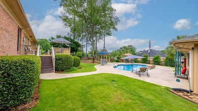
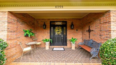
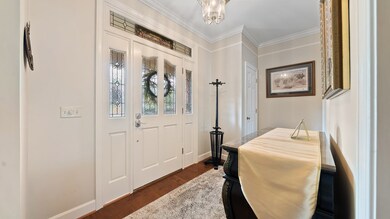
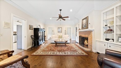

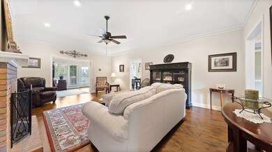
Welcome to 6359 Cape Cod Drive, an exceptional home in the highly desirable Brookstone subdivision! Perfectly positioned on a beautifully landscaped corner lot, this all-brick residence offers impressive curb appeal and premium features inside and out. Step into a thoughtfully designed classic split floor plan with rich hardwood floors, granite countertops, and abundant natural light. The heart of the home boasts a spacious kitchen equipped with high-end JennAir appliances and a view that opens to the stunning backyard. Enjoy entertaining in the sunroom, with a wet bar and panoramic views of lush, mature landscaping. With up to 5 bedrooms, this home provides incredible flexibility for families, guests, or a home office setup. The owner's suite is a private retreat featuring his and her closets, a large tiled shower, and a double vanity in the master bath. Out back, paradise awaits: a saltwater pool, gazebo, deck, brick privacy fencing, and a powered workshop—all ready for summer relaxation or weekend projects. The two-car side-entry garage, additional carport, and 2-year-old roof add more value to this outstanding property. Don't miss the chance to own a rare gem in one of Columbus' most sought-after neighborhoods—schedule your showing today!
Last Agent to Sell the Property
Coldwell Banker / Kennon, Parker, Duncan & Davis Brokerage Phone: 7062561000 License #369208 Listed on: 06/19/2025

| Date | Type | Sale Price | Title Company |
|---|---|---|---|
| Special Warranty Deed | $450,000 | None Listed On Document | |
| Warranty Deed | $325,000 | None Available |
| Date | Status | Loan Amount | Loan Type |
|---|---|---|---|
| Open | $225,000 | New Conventional | |
| Previous Owner | $325,000 | Purchase Money Mortgage |
| Date | Event | Price | List to Sale | Price per Sq Ft |
|---|---|---|---|---|
| 07/28/2025 07/28/25 | Sold | $450,000 | 0.0% | $152 / Sq Ft |
| 06/22/2025 06/22/25 | Pending | -- | -- | -- |
| 06/19/2025 06/19/25 | For Sale | $450,000 | -- | $152 / Sq Ft |
| Year | Tax Paid | Tax Assessment Tax Assessment Total Assessment is a certain percentage of the fair market value that is determined by local assessors to be the total taxable value of land and additions on the property. | Land | Improvement |
|---|---|---|---|---|
| 2025 | $5,634 | $171,612 | $25,452 | $146,160 |
| 2024 | $5,633 | $171,612 | $25,452 | $146,160 |
| 2023 | $4,974 | $171,612 | $25,452 | $146,160 |
| 2022 | $5,875 | $133,716 | $25,452 | $108,264 |
| 2021 | $5,869 | $128,120 | $25,452 | $102,668 |
| 2020 | $5,870 | $128,120 | $25,452 | $102,668 |
| 2019 | $5,891 | $128,120 | $25,452 | $102,668 |
| 2018 | $5,891 | $128,120 | $25,452 | $102,668 |
| 2017 | $5,911 | $128,120 | $25,452 | $102,668 |
| 2016 | $5,672 | $150,781 | $25,152 | $125,629 |
| 2015 | $5,554 | $147,737 | $25,152 | $122,585 |
| 2014 | $5,561 | $147,737 | $25,152 | $122,585 |
| 2013 | -- | $147,737 | $25,152 | $122,585 |
A
Seller's Agent in 2025
Adam Greer
Coldwell Banker / Kennon, Parker, Duncan & Davis
(706) 256-1000
23 in this area
80 Total Sales
B
Buyer's Agent in 2025
Brett Vanacore
Keller Williams Realty River Cities
(706) 888-5555
15 in this area
41 Total Sales
Source: Columbus Board of REALTORS® (GA)
MLS Number: 221746
APN: 181-023-008
Disclaimer: Certain information contained herein is derived from information provided by parties other than Homes.com. All information provided is deemed reliable, but is not guaranteed to be accurate and should be independently verified.
![]() IDX information is provided exclusively for personal, non-commercial use, and may not be used for any purpose other than to identify prospective properties consumers may be interested in purchasing. Information is deemed reliable but not guaranteed.
IDX information is provided exclusively for personal, non-commercial use, and may not be used for any purpose other than to identify prospective properties consumers may be interested in purchasing. Information is deemed reliable but not guaranteed.
Ask me questions while you tour the home.