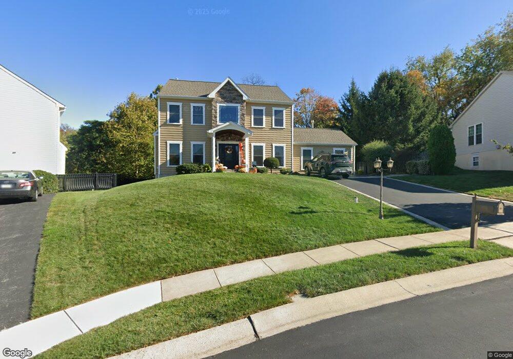
636 Jamie Cir King of Prussia, PA 19406
Estimated Value: $917,000 - $1,210,000
5
Beds
5
Baths
3,607
Sq Ft
$288/Sq Ft
Est. Value
About This Home
This home is located at 636 Jamie Cir, King of Prussia, PA 19406 and is currently estimated at $1,038,106, approximately $287 per square foot. 636 Jamie Cir is a home located in Montgomery County with nearby schools including Caley Elementary School, Upper Merion Middle School, and Upper Merion High School.
Ownership History
Date
Name
Owned For
Owner Type
Purchase Details
Closed on
Feb 11, 2015
Sold by
Wenke Randall J and Ulrich Pauline L
Bought by
Wenke Randall J and Wenke Pauline L
Current Estimated Value
Home Financials for this Owner
Home Financials are based on the most recent Mortgage that was taken out on this home.
Original Mortgage
$320,000
Outstanding Balance
$113,028
Interest Rate
3.66%
Mortgage Type
New Conventional
Estimated Equity
$925,078
Purchase Details
Closed on
Nov 22, 2004
Sold by
Martella Arthur T and Martella Donna
Bought by
Wenke Randall J and Ulrich Pauline L
Home Financials for this Owner
Home Financials are based on the most recent Mortgage that was taken out on this home.
Original Mortgage
$73,350
Interest Rate
5.69%
Purchase Details
Closed on
Nov 14, 1996
Sold by
Merion Estates Ltd and Murdoch William B
Bought by
Martella Arthur T and Martella Donna
Create a Home Valuation Report for This Property
The Home Valuation Report is an in-depth analysis detailing your home's value as well as a comparison with similar homes in the area
Home Values in the Area
Average Home Value in this Area
Purchase History
| Date | Buyer | Sale Price | Title Company |
|---|---|---|---|
| Wenke Randall J | -- | Germantown Title Company | |
| Wenke Randall J | $489,000 | -- | |
| Martella Arthur T | $300,000 | -- |
Source: Public Records
Mortgage History
| Date | Status | Borrower | Loan Amount |
|---|---|---|---|
| Open | Wenke Randall J | $320,000 | |
| Closed | Wenke Randall J | $73,350 |
Source: Public Records
Tax History Compared to Growth
Tax History
| Year | Tax Paid | Tax Assessment Tax Assessment Total Assessment is a certain percentage of the fair market value that is determined by local assessors to be the total taxable value of land and additions on the property. | Land | Improvement |
|---|---|---|---|---|
| 2025 | $8,272 | $268,410 | -- | -- |
| 2024 | $8,272 | $268,410 | -- | -- |
| 2023 | $7,979 | $268,410 | $0 | $0 |
| 2022 | $7,637 | $268,410 | $0 | $0 |
| 2021 | $7,401 | $268,410 | $0 | $0 |
| 2020 | $7,072 | $268,410 | $0 | $0 |
| 2019 | $6,951 | $268,410 | $0 | $0 |
| 2018 | $6,951 | $268,410 | $0 | $0 |
| 2017 | $6,702 | $268,410 | $0 | $0 |
| 2016 | $6,596 | $268,410 | $0 | $0 |
| 2015 | $6,353 | $268,410 | $0 | $0 |
| 2014 | $6,353 | $268,410 | $0 | $0 |
Source: Public Records
Map
Nearby Homes
- 603 Nantucket Cir
- 171 Redwood Rd
- 108 Anderson Rd
- 604 Forge Springs Way
- 709 N Henderson Rd
- 338 Ross Rd Unit C
- 13 Stanbridge St
- 19 Roberts Alley
- 243 Chapel Ln Unit 79A
- 251 Chapel Ln Unit 83B
- 245 Chapel Ln Unit 80B
- 384 Aspen Way Unit 142
- 374 Aspen Way Unit HS 139
- 1022 W Lafayette St
- 243 Jasper Rd
- 361 Aspen Way
- 243 Buttonwood St
- 319 Aspen Way
- 240 Lilac St
- 407 Chestnut Way
- 634 Jamie Cir
- 638 Jamie Cir
- 281 Brownlie Rd
- 632 Jamie Cir
- 600 Jamie Cir
- 279 Brownlie Rd
- 602 Nantucket Cir
- 630 Jamie Cir
- 304 Brownlie Rd
- 300 Brownlie Rd
- 275 Brownlie Rd
- 328 Brownlie Rd
- 602 Jamie Cir
- 600 Nantucket Cir
- 349 Brownlie Rd
- 601 Jamie Cir
- 604 Nantucket Cir
- 615 Jamie Cir
- 628 Jamie Cir
- 269 Brownlie Rd