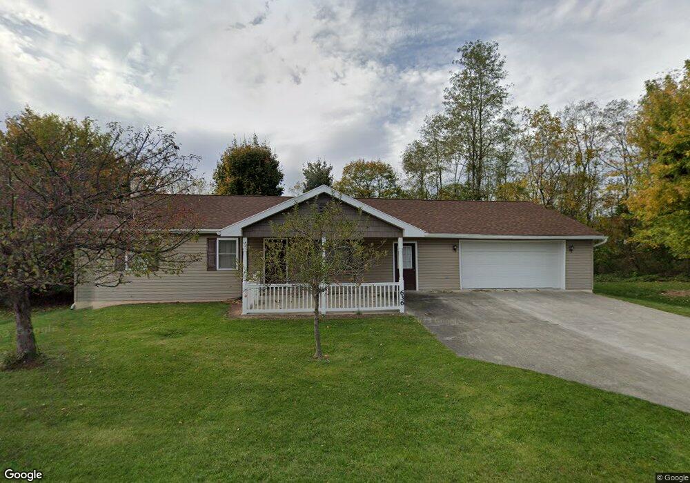
636 Range End Rd Dillsburg, PA 17019
Estimated Value: $230,000 - $313,000
3
Beds
2
Baths
1,026
Sq Ft
$264/Sq Ft
Est. Value
About This Home
This home is located at 636 Range End Rd, Dillsburg, PA 17019 and is currently estimated at $271,055, approximately $264 per square foot. 636 Range End Rd is a home located in York County with nearby schools including Northern Middle School and Northern High School.
Ownership History
Date
Name
Owned For
Owner Type
Purchase Details
Closed on
May 16, 2024
Sold by
Rosenberger Ronald and Rosenberger Keith A
Bought by
Rosenberger Ronald
Current Estimated Value
Purchase Details
Closed on
Feb 29, 2024
Sold by
Lowe James N
Bought by
Lowe Stephen F and Rosenberger Keith A
Purchase Details
Closed on
Nov 3, 1989
Sold by
Reed Carol A
Bought by
Lowe James N
Purchase Details
Closed on
Dec 1, 1980
Bought by
Reed Carol A
Create a Home Valuation Report for This Property
The Home Valuation Report is an in-depth analysis detailing your home's value as well as a comparison with similar homes in the area
Home Values in the Area
Average Home Value in this Area
Purchase History
| Date | Buyer | Sale Price | Title Company |
|---|---|---|---|
| Rosenberger Ronald | -- | None Listed On Document | |
| Lowe Stephen F | -- | None Listed On Document | |
| Lowe James N | $63,900 | -- | |
| Reed Carol A | $41,900 | -- |
Source: Public Records
Tax History Compared to Growth
Tax History
| Year | Tax Paid | Tax Assessment Tax Assessment Total Assessment is a certain percentage of the fair market value that is determined by local assessors to be the total taxable value of land and additions on the property. | Land | Improvement |
|---|---|---|---|---|
| 2025 | $3,364 | $119,206 | $48,600 | $70,606 |
| 2024 | $3,206 | $114,796 | $48,600 | $66,196 |
| 2023 | $3,076 | $114,796 | $48,600 | $66,196 |
| 2022 | $3,012 | $114,796 | $48,600 | $66,196 |
| 2021 | $2,818 | $114,796 | $48,600 | $66,196 |
| 2020 | $2,752 | $114,796 | $48,600 | $66,196 |
| 2019 | $2,684 | $114,796 | $48,600 | $66,196 |
| 2018 | $2,627 | $114,796 | $48,600 | $66,196 |
| 2017 | $2,627 | $114,796 | $48,600 | $66,196 |
| 2016 | $0 | $114,796 | $48,600 | $66,196 |
| 2015 | -- | $114,796 | $48,600 | $66,196 |
| 2014 | -- | $114,796 | $48,600 | $66,196 |
Source: Public Records
Map
Nearby Homes
- 771 Range End Rd
- 104 Furman Rd
- 111 Saint George Dr
- 0 Range End Rd Unit PAYK2075290
- lot 1 Baltimore St
- 45 Chain Saw Rd
- 0 Church St Unit PAYK2054218
- 17 Homewood St
- 1111 S Mountain Rd
- 233 S Baltimore St
- 8 Dove Ct
- 121 S Baltimore St
- 0 Harrisburg St
- 165 Chain Saw Rd
- 140 Quail Dr
- Whitehall II Plan at Stony Run Single Family Homes
- York II Garage Plan at Stony Run Townhomes
- Carnegie II Plan at Stony Run Single Family Homes
- Cranberry II Plan at Stony Run Single Family Homes
- Edgewood II Plan at Stony Run Single Family Homes
- 638 Range End Rd
- 633 Range End Rd
- 700 Range End Rd
- 630 Range End Rd
- 701 Range End Rd
- 702 Range End Rd
- 6 Glenwood Rd
- 704 Range End Rd
- 628 Range End Rd
- 627 Range End Rd
- 626 Range End Rd
- 12 Glenwood Rd
- 625 Range End Rd
- 5 Miller St
- 1 Miller St
- 14 Glenwood Rd
- 9 Miller St
- 706 Range End Rd
- 623 Range End Rd
- 11 Miller St