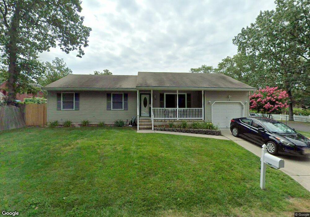
637 Taylor Ave Forked River, NJ 08731
Estimated Value: $389,000 - $457,000
2
Beds
2
Baths
1,248
Sq Ft
$341/Sq Ft
Est. Value
About This Home
This home is located at 637 Taylor Ave, Forked River, NJ 08731 and is currently estimated at $425,387, approximately $340 per square foot. 637 Taylor Ave is a home located in Ocean County with nearby schools including Lacey Township High School.
Ownership History
Date
Name
Owned For
Owner Type
Purchase Details
Closed on
Feb 1, 2022
Sold by
Penston Sarah A
Bought by
Carlin Donna and Carlin Anthony John
Current Estimated Value
Home Financials for this Owner
Home Financials are based on the most recent Mortgage that was taken out on this home.
Original Mortgage
$303,300
Outstanding Balance
$281,671
Interest Rate
3.56%
Mortgage Type
New Conventional
Estimated Equity
$143,716
Purchase Details
Closed on
Aug 16, 1996
Sold by
O'Brien Colum
Bought by
Penston John and Penston Sarah
Home Financials for this Owner
Home Financials are based on the most recent Mortgage that was taken out on this home.
Original Mortgage
$92,000
Interest Rate
8.4%
Purchase Details
Closed on
Aug 20, 1993
Sold by
Lange Vivian
Bought by
O'Brien Colum
Home Financials for this Owner
Home Financials are based on the most recent Mortgage that was taken out on this home.
Original Mortgage
$111,000
Interest Rate
7%
Create a Home Valuation Report for This Property
The Home Valuation Report is an in-depth analysis detailing your home's value as well as a comparison with similar homes in the area
Home Values in the Area
Average Home Value in this Area
Purchase History
| Date | Buyer | Sale Price | Title Company |
|---|---|---|---|
| Carlin Donna | $337,000 | Foundation Title | |
| Carlin Donna | $337,000 | Foundation Title | |
| Penston John | $120,000 | -- | |
| O'Brien Colum | $117,000 | -- |
Source: Public Records
Mortgage History
| Date | Status | Borrower | Loan Amount |
|---|---|---|---|
| Open | Carlin Donna | $303,300 | |
| Closed | Carlin Donna | $303,300 | |
| Previous Owner | Penston John | $92,000 | |
| Previous Owner | O'Brien Colum | $111,000 |
Source: Public Records
Tax History
| Year | Tax Paid | Tax Assessment Tax Assessment Total Assessment is a certain percentage of the fair market value that is determined by local assessors to be the total taxable value of land and additions on the property. | Land | Improvement |
|---|---|---|---|---|
| 2025 | $4,799 | $189,400 | $76,000 | $113,400 |
| 2024 | $4,487 | $189,400 | $76,000 | $113,400 |
Source: Public Records
Map
Nearby Homes
- 650 Chelsea St
- 812 Chelsea St
- 822 Devon St
- 576 Vaughn Ave
- 603 Maria Loretta Ln
- 000 Elwood St
- 504 Devoe Ave
- 923 Tappan St
- 930 Tappan St
- 534 Holmes Ave N
- 932 Elwood St
- 1007 Elwood St
- 1013 Chelsea St
- 0 Bell St Unit NJOC2038820
- 0 Bell St Unit 22536923
- 1972 Glen Oak Dr
- 11 Bell St
- 321 Letts Ave
- 0 Hoyt St Unit 22602566
- 3 Elsiah St
- 649 Elwood St
- 646 Center St
- 643 Taylor Ave (Not Lane)
- 643 Taylor Ave
- 645 Elwood St
- 653 Elwood St
- 643 Elwood St
- 645 Taylor Ave
- 645 Deerhead Lake Dr
- 643 Center St
- 636 Wilbert Ave
- 639 Deerhead Lake Dr
- 650 Elwood St
- 654 Elwood St
- 646 Devon St
- 642 Devon St
- 641 Center St
- 641 Elwood St
- 741 Center St
- 646 Deerhead Lake Dr
Your Personal Tour Guide
Ask me questions while you tour the home.