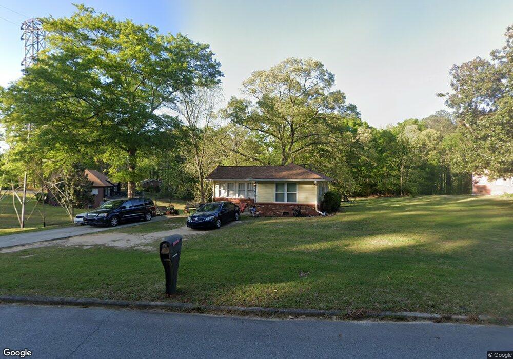
6372 Thompson Dr Union City, GA 30291
Estimated Value: $159,425 - $190,000
2
Beds
1
Bath
839
Sq Ft
$205/Sq Ft
Est. Value
About This Home
This home is located at 6372 Thompson Dr, Union City, GA 30291 and is currently estimated at $172,106, approximately $205 per square foot. 6372 Thompson Dr is a home located in Fulton County with nearby schools including Campbell Elementary School, Renaissance Middle School, and Creekside High School.
Ownership History
Date
Name
Owned For
Owner Type
Purchase Details
Closed on
Apr 18, 2013
Sold by
Bank Of America Na
Bought by
Janice Barnett Ministries Inc
Current Estimated Value
Purchase Details
Closed on
Mar 12, 2013
Sold by
Bank Of America Na
Bought by
Bank Of America Na
Purchase Details
Closed on
Aug 2, 2007
Sold by
Styer William F
Bought by
Price Lawrence
Home Financials for this Owner
Home Financials are based on the most recent Mortgage that was taken out on this home.
Original Mortgage
$64,900
Interest Rate
6.63%
Mortgage Type
New Conventional
Create a Home Valuation Report for This Property
The Home Valuation Report is an in-depth analysis detailing your home's value as well as a comparison with similar homes in the area
Home Values in the Area
Average Home Value in this Area
Purchase History
| Date | Buyer | Sale Price | Title Company |
|---|---|---|---|
| Janice Barnett Ministries Inc | -- | -- | |
| Bank Of America Na | $14,450 | -- | |
| Price Lawrence | $64,900 | -- |
Source: Public Records
Mortgage History
| Date | Status | Borrower | Loan Amount |
|---|---|---|---|
| Previous Owner | Price Lawrence | $64,900 |
Source: Public Records
Tax History Compared to Growth
Tax History
| Year | Tax Paid | Tax Assessment Tax Assessment Total Assessment is a certain percentage of the fair market value that is determined by local assessors to be the total taxable value of land and additions on the property. | Land | Improvement |
|---|---|---|---|---|
| 2025 | $1,395 | $66,720 | $7,200 | $59,520 |
| 2023 | $1,395 | $49,440 | $10,520 | $38,920 |
| 2022 | $785 | $27,800 | $7,560 | $20,240 |
| 2021 | $507 | $20,880 | $5,360 | $15,520 |
| 2020 | $507 | $17,960 | $2,760 | $15,200 |
| 2019 | $470 | $16,640 | $2,720 | $13,920 |
| 2018 | $297 | $10,520 | $1,920 | $8,600 |
| 2017 | $296 | $10,160 | $1,880 | $8,280 |
| 2016 | $0 | $10,160 | $1,880 | $8,280 |
| 2015 | $0 | $10,160 | $1,880 | $8,280 |
| 2014 | $370 | $12,080 | $2,200 | $9,880 |
Source: Public Records
Map
Nearby Homes
- 6421 Raymond Terrace
- 5278 Park Ave
- 6450 Raymond Dr
- 5207 Dixie Lake Rd
- 6496 Raymond Dr
- 6496 Raymond Dr Unit 6496 and 6500
- 6510 Raymond Dr
- 6385 Lower Dixie Lake Rd
- 6442 Watson St
- 0 Ward Rd Unit 7174145
- 0 Ward Rd Unit 20102427
- 6200 Ward Rd
- 6211 Ward Rd
- 3599 Brookstone Way
- 3589 Brookstone Way
- 5079 Alexander Ave
- 3527 Brookstone Way
- 4985 Union St
- 4458 Manor Hill Dr
- 0 Thompson Dr Unit 7296907
- 0 Thompson Dr Unit 10219809
- 0 Thompson Dr Unit 7563497
- 0 Thompson Dr Unit 7441527
- 0 Thompson Dr Unit 7212762
- 0 Thompson Dr Unit 7213858
- 0 Thompson Dr Unit 7173492
- 0 Thompson Dr Unit 8404992
- 0 Thompson Dr Unit 3144694
- 0 Thompson Dr Unit 7210142
- 6376 Thompson Dr
- 6338 Thompson Dr
- 0 Eidson Trail Unit 10344196
- 0 Eidson Trail Unit NIL 20128995
- 0 Eidson Trail Unit 20009544
- 0 Eidson Trail Unit 8313789
- 0 Eidson Trail Unit 7397616
- 0 Eidson Trail Unit 6599557
- 0 Eidson Trail Unit 8627813
- 6339 Thompson Dr