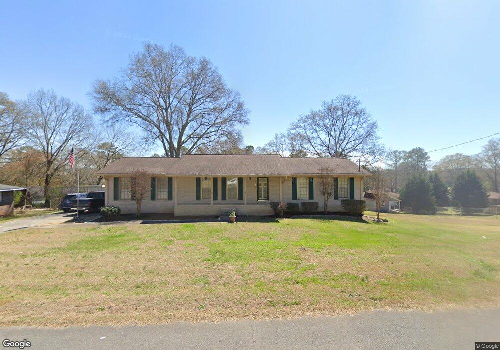
638 Hillside Dr Cedartown, GA 30125
Estimated Value: $238,000 - $281,000
4
Beds
3
Baths
2,280
Sq Ft
$114/Sq Ft
Est. Value
About This Home
This home is located at 638 Hillside Dr, Cedartown, GA 30125 and is currently estimated at $259,874, approximately $113 per square foot. 638 Hillside Dr is a home located in Polk County with nearby schools including Cedar Christian School and Vineyard Harvester Christian Academy.
Ownership History
Date
Name
Owned For
Owner Type
Purchase Details
Closed on
Feb 13, 2012
Sold by
Arencibia Freddie M and Arencibia P
Bought by
Arencibia Freddy A
Current Estimated Value
Purchase Details
Closed on
Apr 30, 1976
Sold by
Goodman Donald E
Bought by
Arencibia Freddy A
Purchase Details
Closed on
Jun 27, 1973
Sold by
Knight Jimmy D
Bought by
Goodman Donald E
Purchase Details
Closed on
Jan 27, 1972
Sold by
Croker
Bought by
Knight Jimmy D
Purchase Details
Closed on
May 2, 1966
Bought by
Croker
Create a Home Valuation Report for This Property
The Home Valuation Report is an in-depth analysis detailing your home's value as well as a comparison with similar homes in the area
Purchase History
| Date | Buyer | Sale Price | Title Company |
|---|---|---|---|
| Arencibia Freddy A | -- | -- | |
| Arencibia Freddy A | -- | -- | |
| Goodman Donald E | -- | -- | |
| Knight Jimmy D | -- | -- | |
| Croker | -- | -- |
Source: Public Records
Tax History
| Year | Tax Paid | Tax Assessment Tax Assessment Total Assessment is a certain percentage of the fair market value that is determined by local assessors to be the total taxable value of land and additions on the property. | Land | Improvement |
|---|---|---|---|---|
| 2025 | $1,619 | $86,619 | $7,680 | $78,939 |
| 2024 | $1,503 | $86,619 | $7,680 | $78,939 |
| 2023 | $1,167 | $62,571 | $7,680 | $54,891 |
| 2022 | $964 | $54,011 | $5,120 | $48,891 |
| 2021 | $977 | $54,011 | $5,120 | $48,891 |
| 2020 | $978 | $54,011 | $5,120 | $48,891 |
| 2019 | $967 | $49,327 | $5,576 | $43,751 |
| 2018 | $872 | $44,987 | $4,238 | $40,749 |
| 2017 | $857 | $44,987 | $4,238 | $40,749 |
| 2016 | $857 | $44,987 | $4,238 | $40,749 |
| 2015 | $864 | $45,228 | $4,238 | $40,990 |
| 2014 | $869 | $45,210 | $4,166 | $41,044 |
Source: Public Records
Map
Nearby Homes
- 645 Valley Rd
- 618 Valley Rd
- 65 Oakwood Dr
- 77 Ben Dr W
- 0 Woodall Rd Unit 7730884
- 0 Woodall Rd Unit 10705831
- 1101 East Ave
- 305 Greenview Ct
- 10 Woodglen Dr
- 202 Ridgewood Rd
- 0 Joy Dr Unit 7702866
- 0 Joy Dr Unit 10669012
- 0 Joy Dr Unit 56
- 00 Joy Dr
- 254 E Girard Ave
- 0 Blanche Rd Unit 10668579
- 0 Blanche Rd Unit 7701366
- 206 Turner St
- 220 John Phillips Rd
- 240 John Phillips Rd
- 642 Hillside Dr
- 641 Hillside Dr
- 646 Hillside Dr
- 633 Woodland Rd
- 633 Hillside Dr
- 637 Woodland Rd
- 629 Woodland Rd
- 645 Hillside Dr
- 641 Woodland Rd
- 625 Woodland Rd
- 629 Hillside Dr
- 644 Collard Valley Rd
- 649 Hillside Dr
- 640 Collard Valley Rd
- 645 Woodland Rd
- 621 Woodland Rd
- 622 Woodland Rd
- 626 Hillside Dr
- 626 Woodland Rd
- 618 Woodland Rd
Your Personal Tour Guide
Ask me questions while you tour the home.