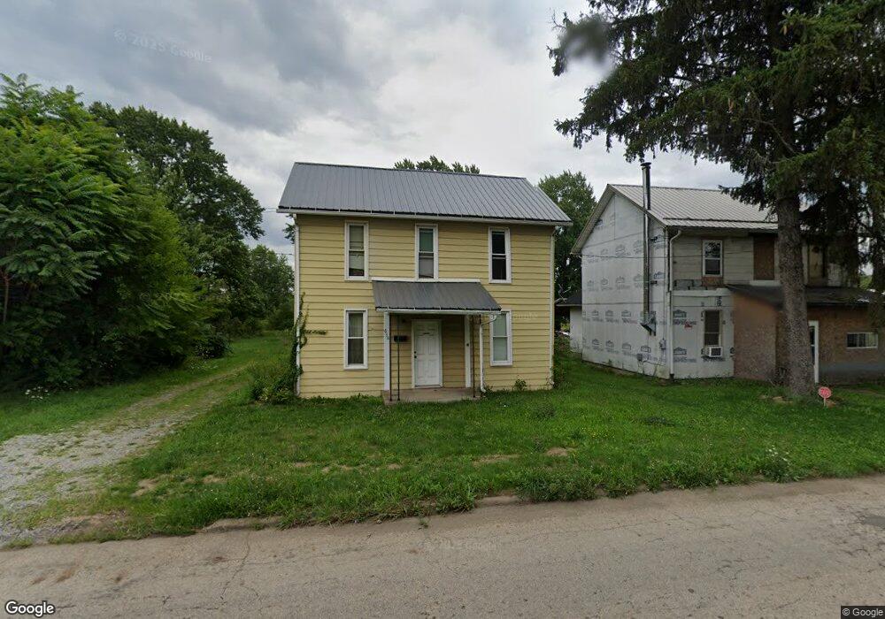
638 S Mahoning Ave Alliance, OH 44601
Estimated Value: $22,615 - $84,000
3
Beds
1
Bath
1,348
Sq Ft
$47/Sq Ft
Est. Value
About This Home
This home is located at 638 S Mahoning Ave, Alliance, OH 44601 and is currently estimated at $63,154, approximately $46 per square foot. 638 S Mahoning Ave is a home located in Mahoning County with nearby schools including Alliance Intermediate School at Northside, Alliance Elementary School at Rockhill, and Alliance Middle School.
Ownership History
Date
Name
Owned For
Owner Type
Purchase Details
Closed on
Jan 12, 2022
Sold by
Paxson William C
Bought by
Nitz Janice
Current Estimated Value
Purchase Details
Closed on
Nov 24, 2021
Sold by
Billiter Matthew
Bought by
Paxson William C
Purchase Details
Closed on
May 20, 2020
Sold by
Popa Don A
Bought by
Billiter Matthew
Purchase Details
Closed on
May 2, 2015
Sold by
Popa Matthew B
Bought by
Popa Don A
Purchase Details
Closed on
Dec 12, 2014
Sold by
Estate Of Arlyis A Popa
Bought by
Grove Michelle L and Popa Don A
Purchase Details
Closed on
Oct 10, 2014
Sold by
Grove Michelle L and Grove Larry E
Bought by
Popa Don A and Popa Matthew B
Purchase Details
Closed on
Mar 6, 1986
Bought by
Popa John and Popa Arlyis T
Create a Home Valuation Report for This Property
The Home Valuation Report is an in-depth analysis detailing your home's value as well as a comparison with similar homes in the area
Home Values in the Area
Average Home Value in this Area
Purchase History
| Date | Buyer | Sale Price | Title Company |
|---|---|---|---|
| Nitz Janice | $5,000 | None Available | |
| Paxson William C | $10,350 | None Available | |
| Billiter Matthew | $35,000 | Heritage Union Title Co Ltd | |
| Popa Don A | -- | Attorney | |
| Grove Michelle L | -- | None Available | |
| Popa Don A | -- | Attorney | |
| Popa John | -- | -- |
Source: Public Records
Tax History Compared to Growth
Tax History
| Year | Tax Paid | Tax Assessment Tax Assessment Total Assessment is a certain percentage of the fair market value that is determined by local assessors to be the total taxable value of land and additions on the property. | Land | Improvement |
|---|---|---|---|---|
| 2024 | $336 | $8,060 | $780 | $7,280 |
| 2023 | $350 | $8,060 | $780 | $7,280 |
| 2022 | $314 | $6,620 | $610 | $6,010 |
| 2021 | $292 | $6,620 | $610 | $6,010 |
| 2020 | $303 | $6,620 | $610 | $6,010 |
| 2019 | $270 | $5,660 | $610 | $5,050 |
| 2018 | $294 | $5,660 | $610 | $5,050 |
| 2017 | $291 | $5,660 | $610 | $5,050 |
| 2016 | $322 | $6,240 | $610 | $5,630 |
| 2015 | $317 | $6,240 | $610 | $5,630 |
| 2014 | $3 | $6,240 | $610 | $5,630 |
| 2013 | $3 | $6,240 | $610 | $5,630 |
Source: Public Records
Map
Nearby Homes
- 22841 Lake Park Blvd
- 831 Wade Ave
- 814 Milner St
- 442 S Liberty Ave
- 1233 Woodland Ave
- 1044 S Liberty Ave
- 548 E High St
- V/L S Fredeom Ave
- 452 E Summit St
- 1005 S Freedom Ave
- 432 S Linden Ave
- 404 S Linden Ave
- 729 Waugh St
- 834 Devine St
- 328 N Webb Ave
- 361 E Main St
- 167 11th St
- 1437 S Linden Ave
- 652 N Webb Ave
- 807 S Union Ave
- 634 S Mahoning Ave
- 654 S Mahoning Ave
- 632 S Mahoning Ave
- 604 S Mahoning Ave
- 631 S Mahoning Ave
- 613 S Mahoning Ave
- 656 Willow Ave
- 666 Willow Ave
- 545 S Mahoning Ave
- 1422 E Summit St
- 530 S Mahoning Ave
- 1404 E Summit St
- 22865 Lake Park Blvd
- 529 S Mahoning Ave
- 22849 Lake Park Blvd
- 723 S Mahoning Ave
- 510 S Mahoning Ave
- 22821 Lake Park Blvd
- 22813 Lake Park Blvd
- 22862 Alden Ave