Estimated Value: $411,000 - $529,000
4
Beds
3
Baths
2,517
Sq Ft
$186/Sq Ft
Est. Value
About This Home
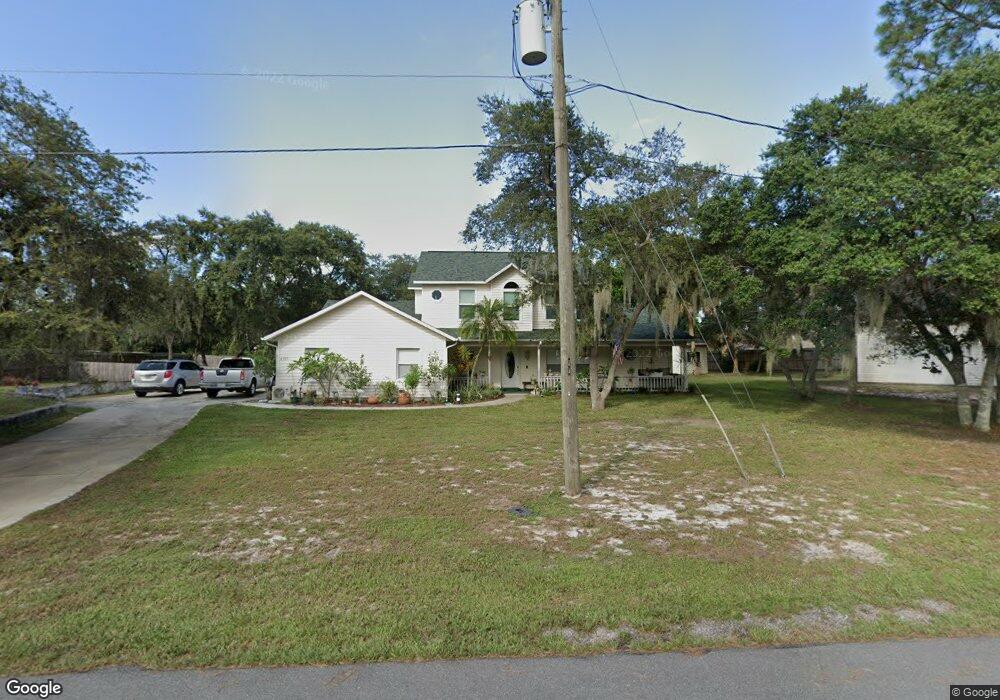
This home is located at 6385 Manila Dr, Cocoa, FL 32927 and is currently estimated at $469,195, approximately $186 per square foot. 6385 Manila Dr is a home located in Brevard County with nearby schools including Challenger 7 Elementary School, Space Coast Junior/Senior High School, and East Atlantic Prep of Brevard County.
Ownership History
Date
Name
Owned For
Owner Type
Purchase Details
Closed on
Sep 5, 2024
Sold by
Andrews James S and Andrews Lauri A
Bought by
Andrews Family Trust and Andrews
Current Estimated Value
Purchase Details
Closed on
Feb 14, 1995
Sold by
Clarke Billy Ray and Clarke Patricia Jane
Bought by
Andrews James S and Andrews Lauri A
Home Financials for this Owner
Home Financials are based on the most recent Mortgage that was taken out on this home.
Original Mortgage
$15,000
Interest Rate
9.21%
Create a Home Valuation Report for This Property
The Home Valuation Report is an in-depth analysis detailing your home's value as well as a comparison with similar homes in the area
Home Values in the Area
Average Home Value in this Area
Purchase History
| Date | Buyer | Sale Price | Title Company |
|---|---|---|---|
| Andrews Family Trust | $100 | None Listed On Document | |
| Andrews James S | $20,000 | -- |
Source: Public Records
Mortgage History
| Date | Status | Borrower | Loan Amount |
|---|---|---|---|
| Previous Owner | Andrews James S | $15,000 |
Source: Public Records
Tax History Compared to Growth
Tax History
| Year | Tax Paid | Tax Assessment Tax Assessment Total Assessment is a certain percentage of the fair market value that is determined by local assessors to be the total taxable value of land and additions on the property. | Land | Improvement |
|---|---|---|---|---|
| 2025 | $2,718 | $203,890 | -- | -- |
| 2024 | $2,634 | $193,140 | -- | -- |
| 2023 | $2,634 | $184,590 | $0 | $0 |
| 2022 | $2,471 | $179,220 | $0 | $0 |
| 2021 | $2,512 | $174,000 | $0 | $0 |
| 2020 | $2,433 | $171,600 | $0 | $0 |
| 2019 | $2,378 | $167,750 | $0 | $0 |
| 2018 | $2,381 | $164,630 | $0 | $0 |
| 2017 | $2,396 | $161,250 | $0 | $0 |
| 2016 | $2,424 | $157,940 | $36,000 | $121,940 |
| 2015 | $2,479 | $156,850 | $30,000 | $126,850 |
| 2014 | $2,492 | $155,610 | $22,000 | $133,610 |
Source: Public Records
Map
Nearby Homes
- 6410 Lookout Dr
- 0 Fay Blvd Unit 1011912
- 6575 Dallas Ave
- 780 Alcazar Ave
- 1108 Vineland St
- 0000 Birch Dr
- 4300 Fay Blvd
- 641 Lindsay Ave
- 520 Arabella Ln
- 995 Barclay Dr
- 1015 Hibiscus St
- 672 Altura Dr
- 1164 Aron St
- 961 Kaufman St
- 973 Kaufman St
- 6037 Anne Ave
- 522 Clearview Dr
- 4200 Lee Hall Place
- 453 Camel Cir
- 1008 Jersey St
- 6345 Manila Dr
- 6395 Manila Dr
- 6380 Manila Dr
- 6335 Manila Dr
- 6370 Manila Dr
- 6390 Manila Dr
- 6405 Manila Dr
- 6350 Manila Dr
- 6360 Manila Dr
- 6340 Manila Dr
- 3955 Newport St
- 6400 Manila Dr
- 6325 Manila Dr
- 6330 Manila Dr
- 6375 Lookout Dr
- 3945 Newport St
- 6385 Lookout Dr
- 6365 Lookout Dr
- 6320 Manila Dr
- 6410 Manila Dr