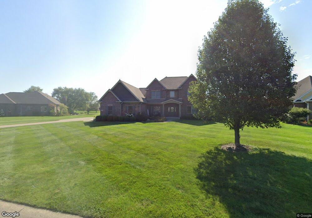
6388 Independence Ct Pendleton, IN 46064
Estimated Value: $448,000 - $564,000
4
Beds
3
Baths
2,856
Sq Ft
$179/Sq Ft
Est. Value
About This Home
This home is located at 6388 Independence Ct, Pendleton, IN 46064 and is currently estimated at $512,490, approximately $179 per square foot. 6388 Independence Ct is a home located in Madison County with nearby schools including Pendleton Elementary School and Pendleton Heights Middle School.
Ownership History
Date
Name
Owned For
Owner Type
Purchase Details
Closed on
Jan 10, 2013
Sold by
Builders Financial Services Inc
Bought by
Graham Benjamin J and Graham Nicole L
Current Estimated Value
Home Financials for this Owner
Home Financials are based on the most recent Mortgage that was taken out on this home.
Original Mortgage
$341,789
Outstanding Balance
$238,930
Interest Rate
3.31%
Mortgage Type
New Conventional
Estimated Equity
$273,560
Purchase Details
Closed on
Apr 28, 2010
Sold by
Zachary Properties Inc
Bought by
Builders Financial Services Inc
Create a Home Valuation Report for This Property
The Home Valuation Report is an in-depth analysis detailing your home's value as well as a comparison with similar homes in the area
Home Values in the Area
Average Home Value in this Area
Purchase History
| Date | Buyer | Sale Price | Title Company |
|---|---|---|---|
| Graham Benjamin J | -- | None Available | |
| Builders Financial Services Inc | -- | -- |
Source: Public Records
Mortgage History
| Date | Status | Borrower | Loan Amount |
|---|---|---|---|
| Open | Graham Benjamin J | $341,789 |
Source: Public Records
Tax History
| Year | Tax Paid | Tax Assessment Tax Assessment Total Assessment is a certain percentage of the fair market value that is determined by local assessors to be the total taxable value of land and additions on the property. | Land | Improvement |
|---|---|---|---|---|
| 2025 | $4,252 | $470,800 | $59,700 | $411,100 |
| 2024 | $4,252 | $425,200 | $59,700 | $365,500 |
| 2023 | $3,935 | $393,500 | $56,800 | $336,700 |
| 2022 | $3,930 | $392,000 | $54,100 | $337,900 |
| 2021 | $3,643 | $364,300 | $54,100 | $310,200 |
| 2020 | $3,519 | $350,900 | $51,600 | $299,300 |
| 2019 | $3,462 | $345,200 | $51,600 | $293,600 |
| 2018 | $3,232 | $322,200 | $51,600 | $270,600 |
| 2017 | $3,181 | $318,100 | $51,600 | $266,500 |
| 2016 | $3,219 | $320,900 | $51,600 | $269,300 |
| 2014 | $3,231 | $323,100 | $51,600 | $271,500 |
| 2013 | $3,231 | $1,000 | $1,000 | $0 |
Source: Public Records
Map
Nearby Homes
- 7113 Theo Baker Blvd
- 5758 Bancroft Dr
- 6049 W Foster Branch Dr
- 5752 Bancroft Dr
- 5757 Bancroft Dr
- 5746 Bancroft Dr
- 5740 Bancroft Dr
- 7145 Theo Baker Blvd
- 7153 Theo Baker Blvd
- 5734 Bancroft Dr
- 7121 Theo Baker Blvd
- 7129 Theo Baker Blvd
- 7105 Theo Baker Blvd
- Fairfax Plan at Baker's Pointe
- Henley Plan at Baker's Pointe
- Chatham Plan at Baker's Pointe
- Lyndhurst Plan at Baker's Pointe
- Johnstown Plan at Baker's Pointe
- Dayton Plan at Baker's Pointe
- Stamford Plan at Baker's Pointe
- 6408 Independence Ct
- 6387 W Congress Dr
- L #74 Independence Ct
- L #73 Independence Ct
- L #69 Independence Ct
- L #70 Independence Ct
- L #72 Independence Ct
- L #71 Independence Ct
- 6430 Independence Ct
- 6413 Independence Ct
- 0 Independence Dr Unit 2864028
- 0 Independence Dr Unit 2864737
- 0 Independence Dr Unit 2864729
- 0 Independence Dr Unit 2864726
- 0 Independence Ct Unit 2868700
- 0 Independence Ct Unit 2868699
- 0 Independence Ct Unit 2868698
- 0 Independence Ct Unit 2868696
- 0 Independence Dr Unit 2953352
- 0 Independence Dr Unit 2953348
Your Personal Tour Guide
Ask me questions while you tour the home.