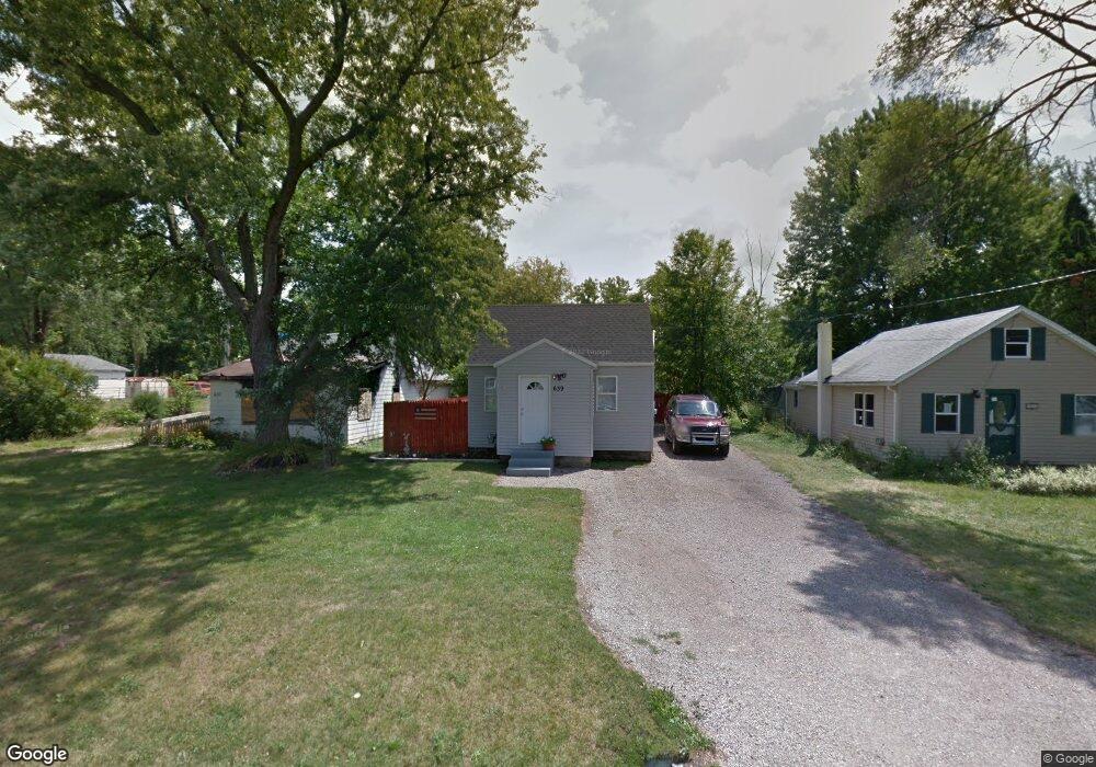
639 Carrier St Lansing, MI 48906
Creston NeighborhoodEstimated Value: $91,193 - $122,000
2
Beds
1
Bath
760
Sq Ft
$142/Sq Ft
Est. Value
About This Home
This home is located at 639 Carrier St, Lansing, MI 48906 and is currently estimated at $107,798, approximately $141 per square foot. 639 Carrier St is a home located in Ingham County with nearby schools including Gier Park School, Pattengill Academy, and Eastern High School.
Ownership History
Date
Name
Owned For
Owner Type
Purchase Details
Closed on
Apr 4, 2012
Sold by
Webster Ralph Grover
Bought by
Webster Elizabeth R
Current Estimated Value
Home Financials for this Owner
Home Financials are based on the most recent Mortgage that was taken out on this home.
Original Mortgage
$50,500
Outstanding Balance
$34,864
Interest Rate
3.9%
Mortgage Type
FHA
Estimated Equity
$72,934
Purchase Details
Closed on
May 11, 2009
Sold by
Lozano Saul and Lozano Maria A
Bought by
Morequity Inc
Purchase Details
Closed on
Apr 27, 2004
Sold by
Titov Paul
Bought by
Lozano Saul J
Home Financials for this Owner
Home Financials are based on the most recent Mortgage that was taken out on this home.
Original Mortgage
$71,900
Interest Rate
5.5%
Mortgage Type
Purchase Money Mortgage
Purchase Details
Closed on
Mar 27, 2002
Sold by
Equicredit Corp Of America
Bought by
Homecomings Financial Network Inc
Purchase Details
Closed on
Jan 31, 2002
Sold by
Whitmore Diana M
Bought by
Equicredit Corp Of America
Purchase Details
Closed on
Nov 5, 1999
Sold by
First National Bank Of America
Bought by
Covey Phyllis B and Covey Robert J
Purchase Details
Closed on
Sep 1, 1999
Sold by
Covey Bob and Covey Phyllis
Bought by
Whitmore Diane M
Home Financials for this Owner
Home Financials are based on the most recent Mortgage that was taken out on this home.
Original Mortgage
$48,000
Interest Rate
11.12%
Mortgage Type
Purchase Money Mortgage
Purchase Details
Closed on
Aug 25, 1999
Sold by
Sheen Stock Kerry Renee
Bought by
Wallace Rodney R
Home Financials for this Owner
Home Financials are based on the most recent Mortgage that was taken out on this home.
Original Mortgage
$48,000
Interest Rate
11.12%
Mortgage Type
Purchase Money Mortgage
Purchase Details
Closed on
Aug 6, 1998
Sold by
Covey Bob and Covey Phyllis
Bought by
Whitmore Diana M
Purchase Details
Closed on
Aug 19, 1997
Bought by
Covey Robert J and Covey Phyllis
Purchase Details
Closed on
Jun 13, 1997
Sold by
Nicholas William - Sheriff
Bought by
First Nat'L Bank Of Michigan
Create a Home Valuation Report for This Property
The Home Valuation Report is an in-depth analysis detailing your home's value as well as a comparison with similar homes in the area
Home Values in the Area
Average Home Value in this Area
Purchase History
| Date | Buyer | Sale Price | Title Company |
|---|---|---|---|
| Webster Elizabeth R | $60,000 | Midstate Title Agency Llc | |
| Morequity Inc | $88,887 | None Available | |
| Lozano Saul J | $71,900 | Mid | |
| Homecomings Financial Network Inc | -- | -- | |
| Equicredit Corp Of America | $51,045 | -- | |
| Covey Phyllis B | $29,800 | -- | |
| Whitmore Diane M | $37,000 | -- | |
| Wallace Rodney R | $57,000 | -- | |
| Whitmore Diana M | $37,000 | -- | |
| Covey Robert J | -- | -- | |
| First Nat'L Bank Of Michigan | $26,100 | -- |
Source: Public Records
Mortgage History
| Date | Status | Borrower | Loan Amount |
|---|---|---|---|
| Open | Webster Elizabeth R | $50,500 | |
| Previous Owner | Lozano Saul J | $71,900 | |
| Previous Owner | Whitmore Diane M | $48,000 | |
| Previous Owner | Wallace Rodney R | $45,600 |
Source: Public Records
Tax History Compared to Growth
Tax History
| Year | Tax Paid | Tax Assessment Tax Assessment Total Assessment is a certain percentage of the fair market value that is determined by local assessors to be the total taxable value of land and additions on the property. | Land | Improvement |
|---|---|---|---|---|
| 2025 | $1,620 | $34,700 | $5,300 | $29,400 |
| 2024 | $1,522 | $35,000 | $5,300 | $29,700 |
| 2023 | $1,522 | $30,600 | $5,300 | $25,300 |
| 2022 | $1,376 | $28,300 | $6,000 | $22,300 |
| 2021 | $1,348 | $25,100 | $5,300 | $19,800 |
| 2020 | $1,339 | $24,500 | $5,300 | $19,200 |
| 2019 | $1,281 | $23,400 | $5,300 | $18,100 |
| 2018 | $1,204 | $20,300 | $5,300 | $15,000 |
| 2017 | $1,151 | $20,300 | $5,300 | $15,000 |
| 2016 | $1,101 | $19,900 | $5,300 | $14,600 |
| 2015 | $1,101 | $19,100 | $10,591 | $8,509 |
| 2014 | $1,101 | $18,700 | $11,347 | $7,353 |
Source: Public Records
Map
Nearby Homes
- 627 W Frederick Ave
- 310 W Frederick Ave
- 3425 Turner Rd
- 16967 Jones Lake Rd
- 415 Filley St
- 712 W Sheridan Rd
- 714 W Sheridan Rd
- 1523 Biltmore Blvd
- 117 Desander Dr Unit 117
- 16653 Jerry Rd
- 109 Desander Dr Unit 109
- 3021 N Grand River Ave
- 85 Nettie Ave Unit 85
- 213 E Thomas St
- 2508 Gary Ave
- 152 Donald Ave Unit 152
- 5250 N Grand River Ave
- 151 Donald Ave Unit 151
- 533 Community St
- 1616 Roseneath Ave