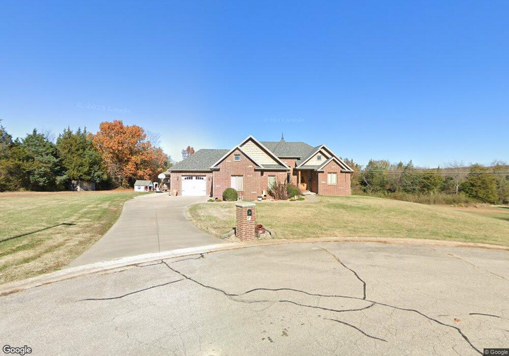
639 Joseph Ct Lebanon, MO 65536
Estimated Value: $360,000 - $767,000
--
Bed
1
Bath
5,551
Sq Ft
$108/Sq Ft
Est. Value
About This Home
This home is located at 639 Joseph Ct, Lebanon, MO 65536 and is currently estimated at $598,882, approximately $107 per square foot. 639 Joseph Ct is a home located in Laclede County with nearby schools including Joe D. Esther Elementary School, Boswell Elementary School, and Maplecrest Elementary School.
Ownership History
Date
Name
Owned For
Owner Type
Purchase Details
Closed on
Sep 4, 2007
Sold by
Oneil Thomas J
Bought by
Deskins Alvin D and Deskins Debbie J
Current Estimated Value
Home Financials for this Owner
Home Financials are based on the most recent Mortgage that was taken out on this home.
Original Mortgage
$18,000
Outstanding Balance
$11,484
Interest Rate
6.72%
Mortgage Type
Future Advance Clause Open End Mortgage
Estimated Equity
$587,398
Purchase Details
Closed on
Mar 11, 2005
Sold by
Oneil Robert E and Oneil Krista L
Bought by
Oneil Thomas J and Oneil Lucy D
Create a Home Valuation Report for This Property
The Home Valuation Report is an in-depth analysis detailing your home's value as well as a comparison with similar homes in the area
Home Values in the Area
Average Home Value in this Area
Purchase History
| Date | Buyer | Sale Price | Title Company |
|---|---|---|---|
| Deskins Alvin D | -- | None Available | |
| Oneil Thomas J | -- | None Available |
Source: Public Records
Mortgage History
| Date | Status | Borrower | Loan Amount |
|---|---|---|---|
| Open | Deskins Alvin D | $18,000 |
Source: Public Records
Tax History Compared to Growth
Tax History
| Year | Tax Paid | Tax Assessment Tax Assessment Total Assessment is a certain percentage of the fair market value that is determined by local assessors to be the total taxable value of land and additions on the property. | Land | Improvement |
|---|---|---|---|---|
| 2025 | $3,837 | $75,830 | $0 | $0 |
| 2024 | $3,837 | $67,300 | $0 | $0 |
| 2023 | $3,954 | $67,300 | $0 | $0 |
| 2022 | $3,684 | $67,300 | $0 | $0 |
| 2021 | $4,058 | $67,298 | $4,750 | $62,548 |
| 2020 | $3,115 | $51,414 | $4,750 | $46,664 |
| 2019 | $2,984 | $51,410 | $4,750 | $46,660 |
| 2018 | $2,800 | $51,410 | $4,750 | $46,660 |
| 2017 | $2,655 | $51,410 | $0 | $0 |
| 2016 | $2,655 | $51,410 | $0 | $0 |
| 2015 | $2,655 | $51,410 | $0 | $0 |
| 2014 | $2,655 | $51,410 | $0 | $0 |
| 2013 | -- | $51,410 | $0 | $0 |
Source: Public Records
Map
Nearby Homes
- TBD Honeysuckle Cir
- 1520 Fairfield Dr
- 708 Herndon Rd
- 1040 Daytona Dr
- 25611 Open Ridge Ln
- 605 Hunters Creek Dr
- 600 Hunters Creek Dr
- 000 Gateway Rd
- 100 S Bend Rd
- 000 Greenfield Rd
- TBD Greenfield Rd
- 18826 Highway 64
- 376 Sunset Dr
- 750 Lynn St
- 1075 Lynn St
- 1491 Brice St
- 231 Raef Rd
- 1540 Woodhill Dr
- 1250 N Jefferson Ave
- 175 Walser St
- 621 Joseph Ct
- 700 Rosewood Dr
- 708 Rosewood Dr
- 1611 Cedar Lawn Dr
- 716 Rosewood Dr
- 724 Rosewood Dr
- 634 Kesiah Dr
- 717 Rosewood Dr
- 1550 Cedar Lawn Dr
- 1712 Honeysuckle Cir
- 732 Rosewood Dr
- 1540 Fairfield Dr
- 1712 Bittersweet Ln
- 1723 Honeysuckle Cir
- 0 Kesiah Cir
- 0 Kesiah Cir
- 740 Rosewood Dr
- 0 Cedar Lawn Dr
- 1548 Cedar Lawn Dr
- 1722 Bittersweet Cir