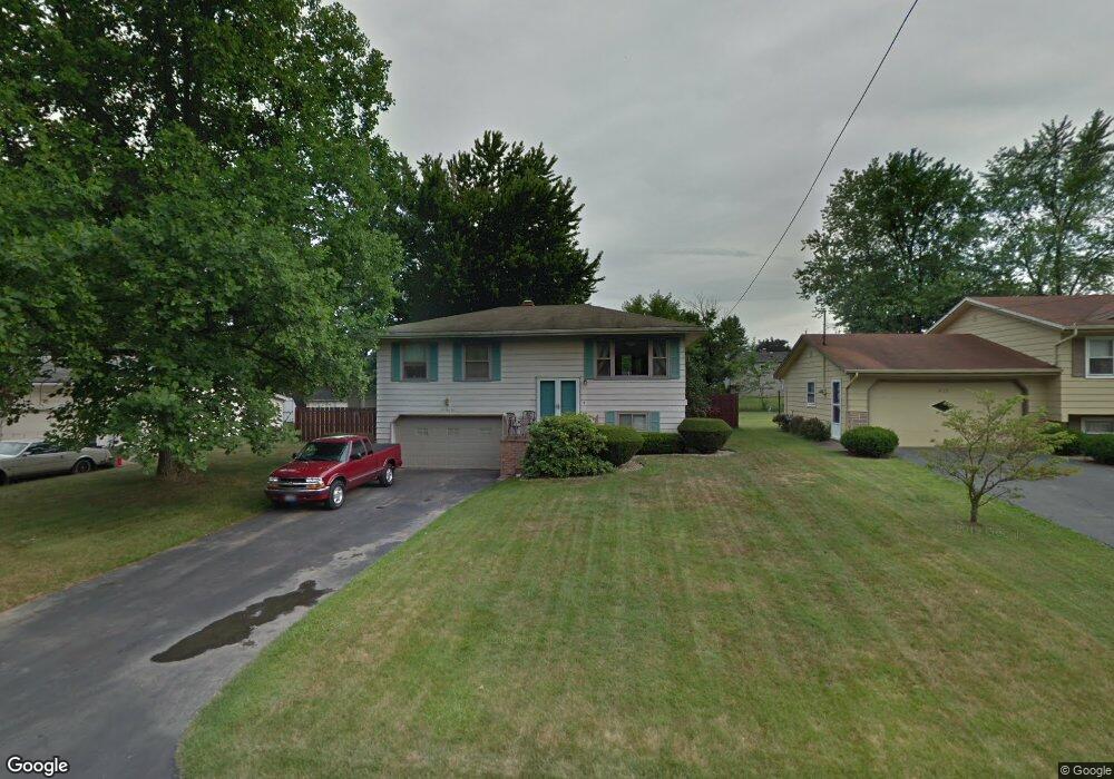
639 Matawan Dr Campbell, OH 44405
Estimated Value: $149,000 - $174,000
3
Beds
1
Bath
1,274
Sq Ft
$125/Sq Ft
Est. Value
About This Home
This home is located at 639 Matawan Dr, Campbell, OH 44405 and is currently estimated at $159,804, approximately $125 per square foot. 639 Matawan Dr is a home located in Mahoning County with nearby schools including Campbell Elementary School, Northeast Ohio Impact Academy, and Memorial High School.
Ownership History
Date
Name
Owned For
Owner Type
Purchase Details
Closed on
Jan 15, 2004
Sold by
Kerekes Jill A
Bought by
Skaleris George
Current Estimated Value
Purchase Details
Closed on
Jun 15, 1994
Bought by
Skaleris George M
Purchase Details
Closed on
Mar 20, 1992
Bought by
Liptak Betty L
Create a Home Valuation Report for This Property
The Home Valuation Report is an in-depth analysis detailing your home's value as well as a comparison with similar homes in the area
Home Values in the Area
Average Home Value in this Area
Purchase History
| Date | Buyer | Sale Price | Title Company |
|---|---|---|---|
| Skaleris George | $7,500 | -- | |
| Skaleris George M | $61,000 | -- | |
| Liptak Betty L | $56,500 | -- |
Source: Public Records
Tax History Compared to Growth
Tax History
| Year | Tax Paid | Tax Assessment Tax Assessment Total Assessment is a certain percentage of the fair market value that is determined by local assessors to be the total taxable value of land and additions on the property. | Land | Improvement |
|---|---|---|---|---|
| 2024 | $1,819 | $34,680 | $4,980 | $29,700 |
| 2023 | $1,797 | $34,680 | $4,980 | $29,700 |
| 2022 | $1,381 | $22,290 | $4,980 | $17,310 |
| 2021 | $1,291 | $22,290 | $4,980 | $17,310 |
| 2020 | $1,311 | $22,290 | $4,980 | $17,310 |
| 2019 | $1,270 | $19,220 | $4,290 | $14,930 |
| 2018 | $1,301 | $19,220 | $4,290 | $14,930 |
| 2017 | $1,302 | $19,220 | $4,290 | $14,930 |
| 2016 | $1,307 | $20,550 | $4,290 | $16,260 |
| 2015 | $1,281 | $20,550 | $4,290 | $16,260 |
| 2014 | $1,277 | $20,550 | $4,290 | $16,260 |
| 2013 | $1,251 | $20,550 | $4,290 | $16,260 |
Source: Public Records
Map
Nearby Homes
- 853 Almasy Dr
- 683 Robinson Rd
- 619 Robinson Rd
- 291 Struthers Liberty Rd
- 409 Pin Oak Place
- 1255 Struthers Coitsville Rd
- 97 Rosary Dr
- 3307 Upland Ave
- 1414 Overlook Ave
- 0 Milligan Rd Unit 5148390
- 746 Whipple Ave
- 684 Devitt Ave
- 3820 Cooper Rd
- 680 Tenney Ave
- 664 Tenney Ave
- 650 Penhale Ave
- 134 Chambers St
- 527 Cynthia Dr
- 0 Oakview Ave
- 247 Reed Ave