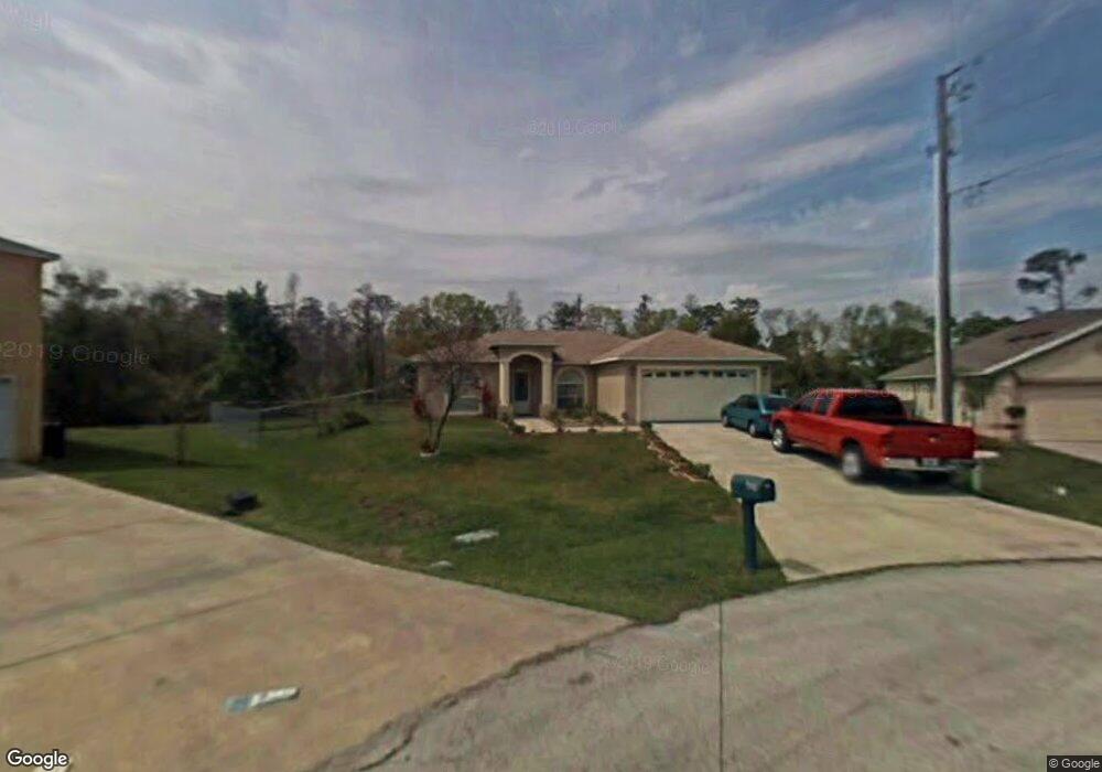
639 Robin Ln Kissimmee, FL 34759
Estimated Value: $232,000 - $265,000
3
Beds
3
Baths
1,136
Sq Ft
$222/Sq Ft
Est. Value
About This Home
This home is located at 639 Robin Ln, Kissimmee, FL 34759 and is currently estimated at $251,624, approximately $221 per square foot. 639 Robin Ln is a home located in Polk County with nearby schools including Haines City Senior High School, Dundee Elementary Academy, and Davenport School Of The Arts.
Ownership History
Date
Name
Owned For
Owner Type
Purchase Details
Closed on
Aug 7, 2017
Sold by
Ruiz Jose M and Dejesus Isable De
Bought by
Ruiz Jose M and Estrella Miosoty
Current Estimated Value
Purchase Details
Closed on
Dec 27, 2000
Sold by
Eldorado Homes Inc
Bought by
Ruiz Jose and Dejesus Isbel
Home Financials for this Owner
Home Financials are based on the most recent Mortgage that was taken out on this home.
Original Mortgage
$88,800
Interest Rate
7.72%
Mortgage Type
New Conventional
Create a Home Valuation Report for This Property
The Home Valuation Report is an in-depth analysis detailing your home's value as well as a comparison with similar homes in the area
Home Values in the Area
Average Home Value in this Area
Purchase History
| Date | Buyer | Sale Price | Title Company |
|---|---|---|---|
| Ruiz Jose M | -- | None Available | |
| Ruiz Jose | $110,000 | -- |
Source: Public Records
Mortgage History
| Date | Status | Borrower | Loan Amount |
|---|---|---|---|
| Open | Ruiz Jose | $96,500 | |
| Closed | Ruiz Jose | $88,800 |
Source: Public Records
Tax History Compared to Growth
Tax History
| Year | Tax Paid | Tax Assessment Tax Assessment Total Assessment is a certain percentage of the fair market value that is determined by local assessors to be the total taxable value of land and additions on the property. | Land | Improvement |
|---|---|---|---|---|
| 2025 | $1,575 | $116,763 | -- | -- |
| 2024 | $1,401 | $113,472 | -- | -- |
| 2023 | $1,401 | $110,167 | $0 | $0 |
| 2022 | $1,340 | $106,958 | $0 | $0 |
| 2021 | $1,341 | $103,843 | $0 | $0 |
| 2020 | $1,308 | $102,409 | $0 | $0 |
| 2018 | $1,239 | $98,240 | $11,000 | $87,240 |
| 2017 | $1,630 | $86,334 | $0 | $0 |
| 2016 | $1,538 | $79,816 | $0 | $0 |
| 2015 | $1,104 | $72,560 | $0 | $0 |
| 2014 | $1,285 | $65,964 | $0 | $0 |
Source: Public Records
Map
Nearby Homes
- 624 Gull Dr
- 605 Raven Ct
- 761 Parrot Ct
- 612 Parakeet Ct
- 618 Parakeet Ct
- 651 Parakeet Ct
- 709 Wren Ln
- 716 Parrot Ct
- 721 Waxwing Ct
- 0 Linnet Ct Unit MFRS5131682
- 511 Hummingbird Ct
- 511 Finch Ct
- 513 Mallard Ct
- 716 Martin Ln
- 714 Martin Ln
- 756 Pelican Ct
- 737 Parrot Ct
- 529 Finch Ct
- 621 Dunlin Ln
- 507 Mallard Ct