Estimated Value: $582,000 - $600,000
5
Beds
3
Baths
2,712
Sq Ft
$218/Sq Ft
Est. Value
About This Home
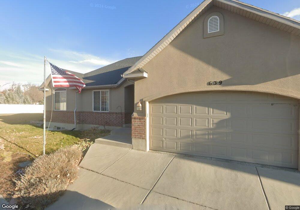
This home is located at 639 W 1290 N, Lehi, UT 84043 and is currently estimated at $589,934, approximately $217 per square foot. 639 W 1290 N is a home located in Utah County with nearby schools including Lehi Elementary School, Lehi Junior High School, and Lehi High School.
Ownership History
Date
Name
Owned For
Owner Type
Purchase Details
Closed on
Sep 15, 2014
Sold by
Busko Kenneth and Busko Denise
Bought by
Newey Whitney K and Newey Cheryl M
Current Estimated Value
Home Financials for this Owner
Home Financials are based on the most recent Mortgage that was taken out on this home.
Original Mortgage
$128,750
Outstanding Balance
$42,381
Interest Rate
4.1%
Mortgage Type
New Conventional
Estimated Equity
$547,553
Purchase Details
Closed on
Aug 3, 2011
Sold by
Maruji Brent A and Maruji Alicia S
Bought by
Busko Kenneth and Busko Denise
Home Financials for this Owner
Home Financials are based on the most recent Mortgage that was taken out on this home.
Original Mortgage
$215,897
Interest Rate
4.53%
Mortgage Type
VA
Purchase Details
Closed on
Jul 2, 2004
Sold by
Courtyard Cove Iii Llc
Bought by
Maruji Brent A and Maruji Alicia S
Create a Home Valuation Report for This Property
The Home Valuation Report is an in-depth analysis detailing your home's value as well as a comparison with similar homes in the area
Home Values in the Area
Average Home Value in this Area
Purchase History
| Date | Buyer | Sale Price | Title Company |
|---|---|---|---|
| Newey Whitney K | -- | First American Title Co Llc | |
| Busko Kenneth | -- | Metro National Title | |
| Maruji Brent A | -- | Provo Land Title Co |
Source: Public Records
Mortgage History
| Date | Status | Borrower | Loan Amount |
|---|---|---|---|
| Open | Newey Whitney K | $128,750 | |
| Previous Owner | Busko Kenneth | $215,897 |
Source: Public Records
Tax History Compared to Growth
Tax History
| Year | Tax Paid | Tax Assessment Tax Assessment Total Assessment is a certain percentage of the fair market value that is determined by local assessors to be the total taxable value of land and additions on the property. | Land | Improvement |
|---|---|---|---|---|
| 2025 | $2,244 | $289,245 | $175,300 | $350,600 |
| 2024 | $2,244 | $262,625 | $0 | $0 |
| 2023 | $2,104 | $267,355 | $0 | $0 |
| 2022 | $2,243 | $276,265 | $0 | $0 |
| 2021 | $2,033 | $378,600 | $101,400 | $277,200 |
| 2020 | $1,918 | $353,000 | $93,900 | $259,100 |
| 2019 | $1,762 | $337,100 | $93,900 | $243,200 |
| 2018 | $1,649 | $298,300 | $84,500 | $213,800 |
| 2017 | $1,585 | $152,460 | $0 | $0 |
| 2016 | $1,649 | $147,180 | $0 | $0 |
| 2015 | $1,633 | $138,325 | $0 | $0 |
| 2014 | $1,626 | $136,950 | $0 | $0 |
Source: Public Records
Map
Nearby Homes
- 1301 N 900 W Unit 12
- 902 W 1500 N
- 1817 W Bad Rock Cir
- 1094 W 1425 N
- 1150 N 200 W Unit 6
- 996 N 200 W
- 1755 N 250 W
- 1610 N 1125 W
- 443 W 820 N
- 155 W State St Unit TRLR 3
- 1329 N 100 E Unit 21
- 1011 W Mountain Way Unit 316
- 68 W State St
- 1295 N 190 E
- 578 N Woods Dr
- 1249 W 1800 N
- 1332 W 1500 N
- 1132 Titan Dr
- 7 E State St
- 1272 W 1800 N