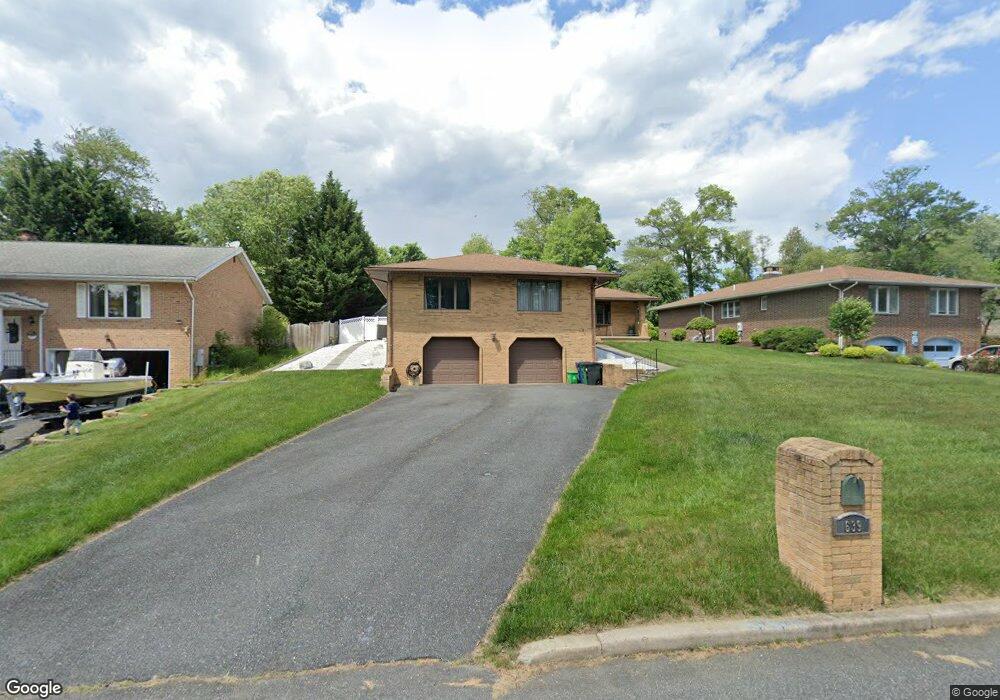
639 Westwood Dr Aberdeen, MD 21001
Estimated Value: $468,000 - $545,000
3
Beds
2
Baths
2,692
Sq Ft
$185/Sq Ft
Est. Value
About This Home
This home is located at 639 Westwood Dr, Aberdeen, MD 21001 and is currently estimated at $496,845, approximately $184 per square foot. 639 Westwood Dr is a home located in Harford County with nearby schools including Bakerfield Elementary School, Aberdeen Middle School, and Aberdeen High School.
Ownership History
Date
Name
Owned For
Owner Type
Purchase Details
Closed on
Apr 26, 2010
Sold by
Auth Michael D
Bought by
Moody Christopher L and Moody Dawn M
Current Estimated Value
Purchase Details
Closed on
Jun 15, 2009
Sold by
Cherry Hill Estates Llc
Bought by
Auth Michael D and Auth Rosemarie A
Home Financials for this Owner
Home Financials are based on the most recent Mortgage that was taken out on this home.
Original Mortgage
$342,400
Interest Rate
4.93%
Purchase Details
Closed on
Feb 4, 2009
Sold by
Auth Richard W
Bought by
Auth Michael D and Auth Rosemarie
Create a Home Valuation Report for This Property
The Home Valuation Report is an in-depth analysis detailing your home's value as well as a comparison with similar homes in the area
Home Values in the Area
Average Home Value in this Area
Purchase History
| Date | Buyer | Sale Price | Title Company |
|---|---|---|---|
| Moody Christopher L | $255,000 | -- | |
| Auth Michael D | $225,000 | -- | |
| Auth Michael D | -- | -- |
Source: Public Records
Mortgage History
| Date | Status | Borrower | Loan Amount |
|---|---|---|---|
| Previous Owner | Auth Michael D | $342,400 | |
| Closed | Moody Christopher L | -- |
Source: Public Records
Tax History Compared to Growth
Tax History
| Year | Tax Paid | Tax Assessment Tax Assessment Total Assessment is a certain percentage of the fair market value that is determined by local assessors to be the total taxable value of land and additions on the property. | Land | Improvement |
|---|---|---|---|---|
| 2025 | $3,200 | $370,767 | $0 | $0 |
| 2024 | $3,200 | $344,633 | $0 | $0 |
| 2023 | $3,036 | $318,500 | $79,200 | $239,300 |
| 2022 | $2,995 | $314,133 | $0 | $0 |
| 2021 | $3,046 | $309,767 | $0 | $0 |
| 2020 | $3,046 | $305,400 | $79,200 | $226,200 |
| 2019 | $2,901 | $290,733 | $0 | $0 |
| 2018 | $2,738 | $276,067 | $0 | $0 |
| 2017 | $2,606 | $261,400 | $0 | $0 |
| 2016 | -- | $259,333 | $0 | $0 |
| 2015 | $2,548 | $257,267 | $0 | $0 |
| 2014 | $2,548 | $255,200 | $0 | $0 |
Source: Public Records
Map
Nearby Homes
- 642 Westwood Dr
- 638 Westwood Dr
- 296 Paradise Rd
- 631 W Bel Air Ave
- 21 Gunnison Dr
- 35 Hillman Ct
- 77 Baker St
- 73 Baker St
- 754 Custis St
- 650 Brenda Ln
- 647 Elm St
- 0 Battle Ave
- 406 Ford St
- 305 Mount Royal Ave
- 0 Harford St Unit MDHR2039982
- 444 Chestnut St
- 188 Farm Rd
- 722 Bur Oak Ct Unit 77
- 458 Bonnett St
- 606 Southgate Rd
- 643 Westwood Dr
- 635 Westwood Dr
- 631 Westwood Dr
- 241 Graceford Dr
- 249 Graceford Dr
- 642 Colaine Dr
- 638 Colaine Dr
- 255 Graceford Dr
- 634 Colaine Dr
- 634 Westwood Dr
- 261 Graceford Dr
- 630 Colaine Dr
- 225 Graceford Dr
- 250 Paradise Rd
- 630 Westwood Dr
- 248 Graceford Dr
- 626 Colaine Dr
- 240 Graceford Dr
- 256 Graceford Dr
- 232 Graceford Dr