Estimated Value: $307,322 - $363,000
3
Beds
2
Baths
1,543
Sq Ft
$220/Sq Ft
Est. Value
About This Home
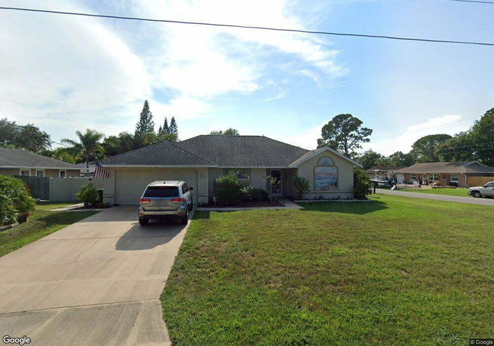
This home is located at 6390 Macauley Ave, Cocoa, FL 32927 and is currently estimated at $339,331, approximately $219 per square foot. 6390 Macauley Ave is a home located in Brevard County with nearby schools including Enterprise Elementary School, Space Coast Junior/Senior High School, and East Atlantic Prep of Brevard County.
Ownership History
Date
Name
Owned For
Owner Type
Purchase Details
Closed on
Apr 24, 2018
Sold by
Priske Sabrina D
Bought by
Priske Sabrina Dawn and Priske Cameron Taylor Elizabeth
Current Estimated Value
Purchase Details
Closed on
Jun 1, 2011
Sold by
Priske Kenneth C and Priske Sabrina D
Bought by
Priske Sabrina D
Purchase Details
Closed on
Dec 15, 1998
Sold by
Priske Kenneth C
Bought by
Priske Kenneth C and Priske Sabrina D
Create a Home Valuation Report for This Property
The Home Valuation Report is an in-depth analysis detailing your home's value as well as a comparison with similar homes in the area
Home Values in the Area
Average Home Value in this Area
Purchase History
| Date | Buyer | Sale Price | Title Company |
|---|---|---|---|
| Priske Sabrina Dawn | -- | Attorney | |
| Priske Sabrina D | -- | Attorney | |
| Priske Kenneth C | $38,600 | -- |
Source: Public Records
Tax History
| Year | Tax Paid | Tax Assessment Tax Assessment Total Assessment is a certain percentage of the fair market value that is determined by local assessors to be the total taxable value of land and additions on the property. | Land | Improvement |
|---|---|---|---|---|
| 2025 | $1,360 | $98,520 | -- | -- |
| 2024 | $1,323 | $95,750 | -- | -- |
| 2023 | $1,323 | $92,970 | $0 | $0 |
| 2022 | $1,232 | $90,270 | $0 | $0 |
| 2021 | $1,226 | $87,650 | $0 | $0 |
| 2020 | $1,162 | $86,440 | $0 | $0 |
| 2019 | $1,097 | $84,500 | $0 | $0 |
| 2018 | $1,088 | $82,930 | $0 | $0 |
| 2017 | $1,077 | $81,230 | $0 | $0 |
| 2016 | $1,075 | $79,560 | $18,000 | $61,560 |
| 2015 | $1,084 | $79,010 | $15,000 | $64,010 |
| 2014 | $1,084 | $78,390 | $11,000 | $67,390 |
Source: Public Records
Map
Nearby Homes
- 5680 Banos Ave
- 5721 Beaverbrook St
- 6481 La Brea Ave
- 6438 Hudson Rd
- 0 Aruin St Unit 1222557
- 6250 Ainsworth Rd
- 6460 Ainsworth Rd
- 23-35-21-JX-B-2 Aruin St
- 6581 Bancroft Ave
- 6460 Homestead Ave
- 6643 Emil Ave
- 6545 Addie Ave
- 6615 Dock Ave
- 6450 Ember Ave
- 6085 Edison St
- 5946 Deer Ln
- 5220 Holden Rd
- 5945 Coker Ave
- 6135 Allmont St
- 5221 Carrick Rd
- 6380 Macauley Ave
- 6423 Alleghany Ave
- 6415 Alleghany Ave
- 5750 Banos Ave
- 5760 Banos Ave
- 6370 Macauley Ave
- 6385 Macauley Ave
- 5740 Banos Ave
- 6407 Alleghany Ave
- 6439 Alleghany Ave
- 6373 Macauley Ave
- 5730 Banos Ave
- 5719 Banos Ave
- 6399 Alleghany Ave
- 5735 Ada St
- 5759 Ada St
- 6422 Alleghany Ave
- 5723 Ada St
- 6430 Alleghany Ave
- 6414 Alleghany Ave
Your Personal Tour Guide
Ask me questions while you tour the home.