Estimated Value: $318,000 - $333,000
2
Beds
2
Baths
1,668
Sq Ft
$197/Sq Ft
Est. Value
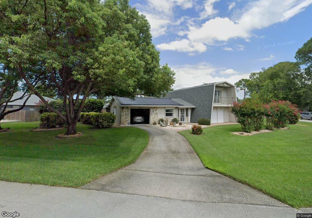
About This Home
This home is located at 6395 Abisco Rd, Cocoa, FL 32927 and is currently estimated at $327,771, approximately $196 per square foot. 6395 Abisco Rd is a home located in Brevard County with nearby schools including Challenger 7 Elementary School, Space Coast Junior/Senior High School, and Sculptor Charter School.
Ownership History
Date
Name
Owned For
Owner Type
Purchase Details
Closed on
Jul 12, 2021
Sold by
Pinkerton George Wayne and Estate Of Georgina Irene Maria
Bought by
Pinkerton George Wayne
Current Estimated Value
Home Financials for this Owner
Home Financials are based on the most recent Mortgage that was taken out on this home.
Original Mortgage
$142,900
Interest Rate
2.9%
Mortgage Type
New Conventional
Create a Home Valuation Report for This Property
The Home Valuation Report is an in-depth analysis detailing your home's value as well as a comparison with similar homes in the area
Home Values in the Area
Average Home Value in this Area
Purchase History
| Date | Buyer | Sale Price | Title Company |
|---|---|---|---|
| Pinkerton George Wayne | -- | Stewart Title |
Source: Public Records
Mortgage History
| Date | Status | Borrower | Loan Amount |
|---|---|---|---|
| Closed | Pinkerton George Wayne | $142,900 |
Source: Public Records
Tax History
| Year | Tax Paid | Tax Assessment Tax Assessment Total Assessment is a certain percentage of the fair market value that is determined by local assessors to be the total taxable value of land and additions on the property. | Land | Improvement |
|---|---|---|---|---|
| 2025 | $2,458 | $188,800 | -- | -- |
| 2024 | $2,349 | $183,480 | -- | -- |
| 2023 | $2,349 | $172,850 | $0 | $0 |
| 2022 | $2,198 | $167,820 | $0 | $0 |
| 2021 | $2,236 | $162,940 | $0 | $0 |
| 2020 | $2,184 | $160,700 | $40,000 | $120,700 |
| 2019 | $2,141 | $157,880 | $35,000 | $122,880 |
| 2018 | $447 | $87,740 | $0 | $0 |
| 2017 | $433 | $85,940 | $0 | $0 |
| 2016 | $427 | $84,180 | $18,000 | $66,180 |
| 2015 | $415 | $83,600 | $15,000 | $68,600 |
| 2014 | $415 | $82,940 | $11,000 | $71,940 |
Source: Public Records
Map
Nearby Homes
- 00 Unknown
- 6450 Ember Ave
- 5220 Holden Rd
- 6375 Cable Ave
- 5215 Holden Rd
- 0000 Grissom Pkwy
- 4975 Fay Blvd
- 5221 Carrick Rd
- 6094 Cardiff Ave
- 6210 Stillwater Ave
- 5095 Hogan Place
- 6620 Grissom Pkwy
- 6438 Hudson Rd
- 5265 Fay Blvd
- 6020 Cannon Ave
- 6615 Dock Ave
- 6760 Cairo Rd
- 6310 Depot Ave
- 6481 La Brea Ave
- 4852 Alfred St
- 6365 Abisco Rd
- 6415 Abisco Rd
- 6370 Abisco Rd
- 6355 Abisco Rd
- 6410 Abisco Rd
- 6425 Abisco Rd
- 6400 Abisco Rd
- 6410 Aberfoyle Ave
- 6380 Abisco Rd
- 6420 Abisco Rd
- 6420 Aberfoyle Ave
- 6380 Aberfoyle Ave
- 6430 Abisco Rd
- 5170 Vance Place
- 6389 Dane Ave
- 5180 Vance Place
- 6377 Dane Ave
- 6430 Aberfoyle Ave
- 5160 Vance Place
- 5190 Vance Place
Your Personal Tour Guide
Ask me questions while you tour the home.