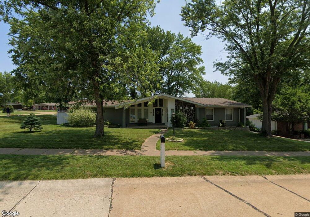
64 Burning Tree Dr Chesterfield, MO 63017
Estimated Value: $361,000 - $456,000
3
Beds
2
Baths
1,850
Sq Ft
$224/Sq Ft
Est. Value
About This Home
This home is located at 64 Burning Tree Dr, Chesterfield, MO 63017 and is currently estimated at $413,989, approximately $223 per square foot. 64 Burning Tree Dr is a home located in St. Louis County with nearby schools including River Bend Elementary School, Parkway Central Middle School, and Parkway Central High School.
Ownership History
Date
Name
Owned For
Owner Type
Purchase Details
Closed on
Nov 21, 2012
Sold by
Sparkman Donna A and Kaster Donna A
Bought by
Igna Cristian M
Current Estimated Value
Home Financials for this Owner
Home Financials are based on the most recent Mortgage that was taken out on this home.
Original Mortgage
$141,391
Outstanding Balance
$97,054
Interest Rate
3.25%
Mortgage Type
FHA
Estimated Equity
$316,935
Purchase Details
Closed on
Jul 24, 1997
Sold by
Zinke Kurt H
Bought by
Zinke Donna K
Create a Home Valuation Report for This Property
The Home Valuation Report is an in-depth analysis detailing your home's value as well as a comparison with similar homes in the area
Home Values in the Area
Average Home Value in this Area
Purchase History
| Date | Buyer | Sale Price | Title Company |
|---|---|---|---|
| Igna Cristian M | $144,000 | Investors Title Co Clayton | |
| Zinke Donna K | -- | -- |
Source: Public Records
Mortgage History
| Date | Status | Borrower | Loan Amount |
|---|---|---|---|
| Open | Igna Cristian M | $141,391 |
Source: Public Records
Tax History
| Year | Tax Paid | Tax Assessment Tax Assessment Total Assessment is a certain percentage of the fair market value that is determined by local assessors to be the total taxable value of land and additions on the property. | Land | Improvement |
|---|---|---|---|---|
| 2025 | $4,167 | $68,900 | $38,670 | $30,230 |
| 2024 | $4,167 | $62,910 | $25,710 | $37,200 |
| 2023 | $4,167 | $62,910 | $25,710 | $37,200 |
| 2022 | $3,549 | $50,790 | $25,710 | $25,080 |
| 2021 | $3,535 | $50,790 | $25,710 | $25,080 |
| 2020 | $3,504 | $48,360 | $22,040 | $26,320 |
| 2019 | $3,428 | $48,360 | $22,040 | $26,320 |
| 2018 | $3,672 | $48,070 | $20,200 | $27,870 |
| 2016 | $3,386 | $43,280 | $16,530 | $26,750 |
Source: Public Records
Map
Nearby Homes
- 13579 Coliseum Dr Unit G
- 13489 Beaulac Dr
- 357 N Woods Mill Rd
- 295 Ridge Trail Dr
- 13515 Coliseum Dr Unit A
- 13503 Coliseum Dr
- 13304 Wood Chapel Dr Unit 35
- 13305 Woodlake Village Ct E
- 13337 Bragstadt Dr
- 1121 Matador Dr Unit 1
- 1239 Creve Coeur Crossing Ln Unit D
- 1231 Creve Coeur Crossing Ln Unit J
- 13222 Cantina Dr Unit 2
- 1104 Cantina Dr
- 14327 Bramblewood Ct
- 13232 Dartagnan Ct
- 14121 Parliament Dr
- 13232 Heirloom Ct
- 1701 Ridgemont Ct
- 14065 Boxford Ct
- 63 Highland Park Dr
- 65 Burning Tree Dr
- 85 Burning Tree Dr
- 73 Burning Tree Dr
- 84 Burning Tree Dr
- 86 Burning Tree Dr
- 72 Highland Park Dr
- 62 Highland Park Dr
- 66 Burning Tree Dr
- 83 Burning Tree Dr
- 87 Burning Tree Dr
- 61 Highland Park Dr
- 74 Burning Tree Dr
- 67 Burning Tree Dr
- 191 Glen Cove Dr
- 192 Glen Cove Dr
- 82 Burning Tree Dr
- 88 Burning Tree Dr
- 641 Highland Park Dr
- 190 Glen Cove Dr
Your Personal Tour Guide
Ask me questions while you tour the home.