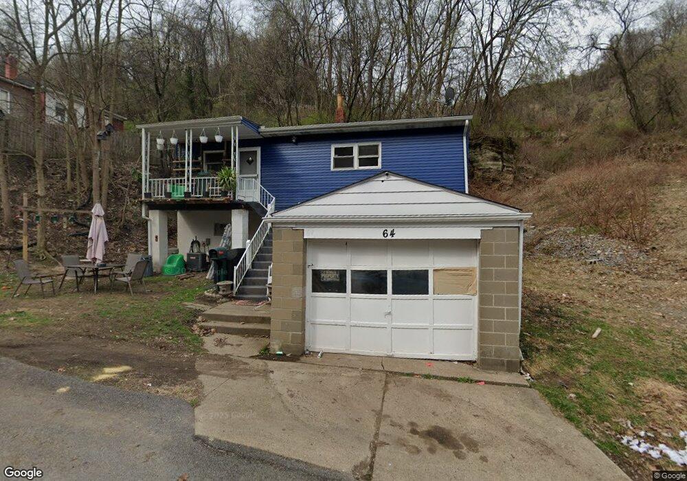
64 Coles Row Mc Kees Rocks, PA 15136
Stowe Township NeighborhoodEstimated Value: $43,000 - $98,000
2
Beds
1
Bath
1,118
Sq Ft
$59/Sq Ft
Est. Value
About This Home
This home is located at 64 Coles Row, Mc Kees Rocks, PA 15136 and is currently estimated at $66,333, approximately $59 per square foot. 64 Coles Row is a home located in Allegheny County with nearby schools including Sto-Rox Primary Center, Sto-Rox Upper Elementary School, and Sto-Rox Junior/Senior High School.
Ownership History
Date
Name
Owned For
Owner Type
Purchase Details
Closed on
Jun 9, 2023
Sold by
Rees Dustin
Bought by
Spaceflow Llc
Current Estimated Value
Purchase Details
Closed on
Sep 6, 2022
Sold by
Greater Western Trust No 200764 and Sullivan Thomas E
Bought by
Rees Dustin
Purchase Details
Closed on
Sep 1, 2022
Sold by
Greater Western Trust # 200764
Bought by
Rees Dustin
Purchase Details
Closed on
Aug 15, 2007
Sold by
Calorie Alberta M
Bought by
1St Greater Western Tr
Home Financials for this Owner
Home Financials are based on the most recent Mortgage that was taken out on this home.
Original Mortgage
$40,000
Interest Rate
6.67%
Mortgage Type
New Conventional
Create a Home Valuation Report for This Property
The Home Valuation Report is an in-depth analysis detailing your home's value as well as a comparison with similar homes in the area
Home Values in the Area
Average Home Value in this Area
Purchase History
| Date | Buyer | Sale Price | Title Company |
|---|---|---|---|
| Spaceflow Llc | $40,000 | -- | |
| Rees Dustin | $5,000 | -- | |
| Rees Dustin | $5,000 | -- | |
| Dustin Rees | $5,000 | -- | |
| 1St Greater Western Tr | $22,000 | -- |
Source: Public Records
Mortgage History
| Date | Status | Borrower | Loan Amount |
|---|---|---|---|
| Previous Owner | 1St Greater Western Tr | $40,000 |
Source: Public Records
Tax History Compared to Growth
Tax History
| Year | Tax Paid | Tax Assessment Tax Assessment Total Assessment is a certain percentage of the fair market value that is determined by local assessors to be the total taxable value of land and additions on the property. | Land | Improvement |
|---|---|---|---|---|
| 2025 | $1,020 | $23,600 | $4,000 | $19,600 |
| 2024 | $1,020 | $23,600 | $4,000 | $19,600 |
| 2023 | $980 | $23,600 | $4,000 | $19,600 |
| 2022 | $949 | $23,600 | $4,000 | $19,600 |
| 2021 | $927 | $23,600 | $4,000 | $19,600 |
| 2020 | $927 | $23,600 | $4,000 | $19,600 |
| 2019 | $927 | $23,600 | $4,000 | $19,600 |
| 2018 | $112 | $23,600 | $4,000 | $19,600 |
| 2017 | $906 | $23,600 | $4,000 | $19,600 |
| 2016 | $112 | $23,600 | $4,000 | $19,600 |
| 2015 | $112 | $23,600 | $4,000 | $19,600 |
| 2014 | $906 | $23,600 | $4,000 | $19,600 |
Source: Public Records
Map
Nearby Homes
- 1550 Glenn Way
- 179 William Cir
- 1447 Fleming Ave
- 1490 Island Ave
- 1421 Fleming Ave
- 270 Wheeler Ave
- 214 Barbara Dr
- 86 Thorncrest Dr
- 230 Lenore Dr
- 48 Ewing Rd
- 104 Thorncrest Dr
- 543 Elizabeth Ave
- 601 Hillcrest Ave
- 124 Pleasant Ridge Rd
- 425 Macarthur St
- 23 Castle View Dr
- 8 Court Place
- 1213 Island Ave
- 813 13th St
- 1406 Broadway Ave