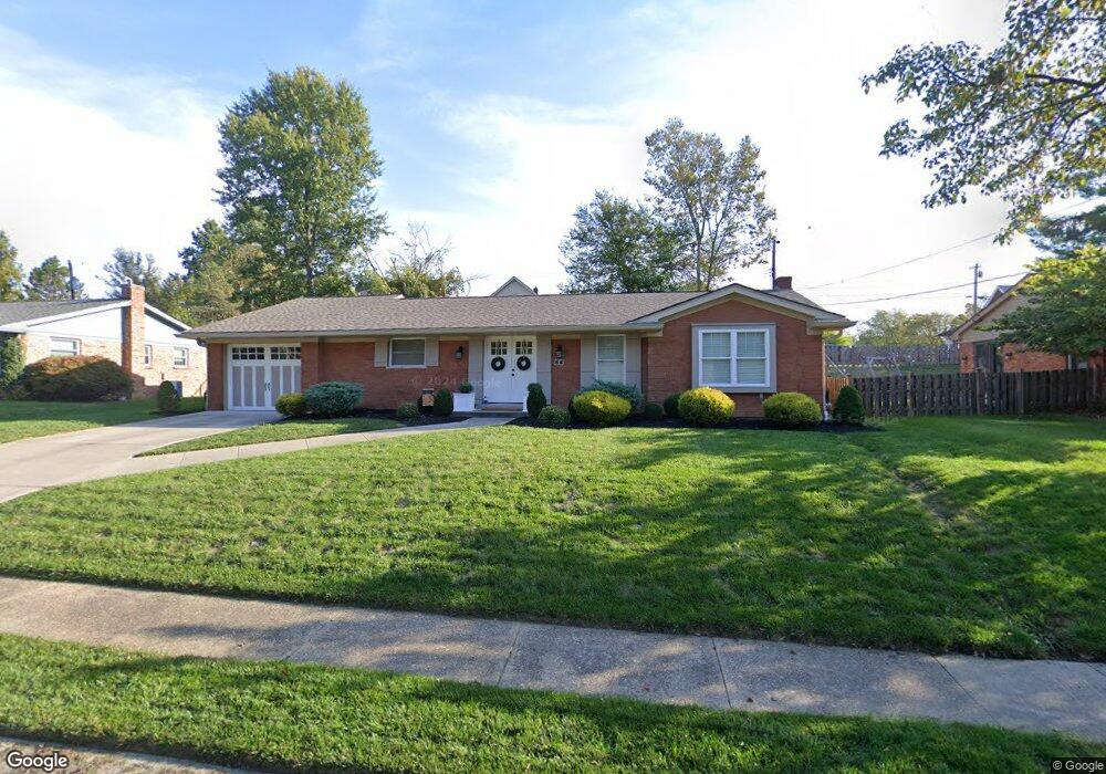
64 Colony South Dr Lakeside Park, KY 41017
Estimated Value: $380,646 - $589,000
3
Beds
3
Baths
1,440
Sq Ft
$313/Sq Ft
Est. Value
About This Home
This home is located at 64 Colony South Dr, Lakeside Park, KY 41017 and is currently estimated at $450,662, approximately $312 per square foot. 64 Colony South Dr is a home located in Kenton County with nearby schools including River Ridge Elementary School, Turkey Foot Middle School, and Dixie Heights High School.
Ownership History
Date
Name
Owned For
Owner Type
Purchase Details
Closed on
Jun 12, 2017
Sold by
Meyer Barry and Meyer Denise
Bought by
Tarkington Sarah A
Current Estimated Value
Home Financials for this Owner
Home Financials are based on the most recent Mortgage that was taken out on this home.
Original Mortgage
$179,000
Outstanding Balance
$148,931
Interest Rate
4.03%
Mortgage Type
New Conventional
Estimated Equity
$301,731
Purchase Details
Closed on
Feb 19, 2016
Sold by
The Bank Of New York Mellon
Bought by
Meyer Barry
Purchase Details
Closed on
Jun 22, 2015
Sold by
Deck Joanne
Bought by
The Bank Of New York Mellon and The Bank Of New York
Purchase Details
Closed on
Mar 9, 2004
Sold by
Estate Of William Henry Galbreath
Bought by
Deck Joanne
Create a Home Valuation Report for This Property
The Home Valuation Report is an in-depth analysis detailing your home's value as well as a comparison with similar homes in the area
Home Values in the Area
Average Home Value in this Area
Purchase History
| Date | Buyer | Sale Price | Title Company |
|---|---|---|---|
| Tarkington Sarah A | $279,000 | None Available | |
| Meyer Barry | $82,000 | Attorney | |
| The Bank Of New York Mellon | -- | Attorney | |
| Deck Joanne | -- | -- |
Source: Public Records
Mortgage History
| Date | Status | Borrower | Loan Amount |
|---|---|---|---|
| Open | Tarkington Sarah A | $179,000 |
Source: Public Records
Tax History Compared to Growth
Tax History
| Year | Tax Paid | Tax Assessment Tax Assessment Total Assessment is a certain percentage of the fair market value that is determined by local assessors to be the total taxable value of land and additions on the property. | Land | Improvement |
|---|---|---|---|---|
| 2024 | $3,588 | $350,000 | $45,000 | $305,000 |
| 2023 | $3,731 | $350,000 | $45,000 | $305,000 |
| 2022 | $3,061 | $279,000 | $40,000 | $239,000 |
| 2021 | $3,125 | $279,000 | $40,000 | $239,000 |
| 2020 | $3,158 | $279,000 | $40,000 | $239,000 |
| 2019 | $3,168 | $279,000 | $40,000 | $239,000 |
| 2018 | $3,177 | $279,000 | $25,000 | $254,000 |
| 2017 | $960 | $82,000 | $25,000 | $57,000 |
| 2015 | $1,248 | $150,000 | $25,000 | $125,000 |
| 2014 | $1,237 | $150,000 | $25,000 | $125,000 |
Source: Public Records
Map
Nearby Homes
- 69 Buttermilk Pike
- 27 Sunnymede Dr
- 17 Bellemonte Ave
- 2401 Carlisle Ave
- 9 Virginia Ave
- 30 Burdsall Ave
- 2696 Dixie Hwy
- 2658 van Deren Dr
- 2542 Avon Dr
- 2666 van Deren Dr
- 21 Oak St
- 2369 Piazza Ridge
- 2558 Avon Dr
- 432 Summit Dr
- 152 Steelway Farm Ct
- 2680 van Deren Dr
- 2674 Turkeyfoot Rd
- 202 Shaker Heights Ln
- 13 Silver Ave
- 109 Highland Ave
- 64 Colony Dr S
- 62 Colony South Dr
- 62 Colony Dr S
- 66 Colony Dr S
- 9999 Colony Dr S
- 0 Colony Dr S
- 66 Colony South Dr
- 61 Buttermilk Pike
- 59 Buttermilk Pike
- 63 Buttermilk Pike
- 63 Colony South Dr
- 63 Colony Dr S
- 65 Colony South Dr
- 61 Colony South Dr
- 68 Colony Dr S
- 58 Colony South Dr
- 68 Colony South Dr
- 58 Colony Dr S
- 55 Buttermilk Pike
- 55 Buttermilk Pike Unit 1082