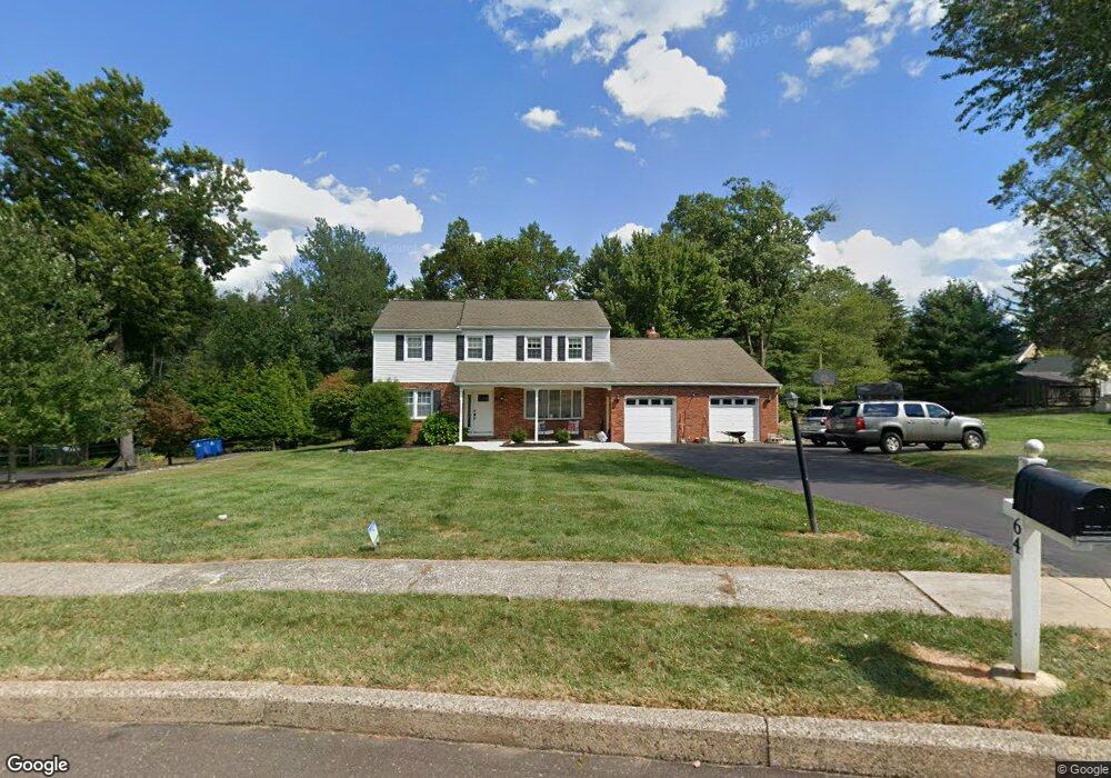
64 Deerpath Rd Chalfont, PA 18914
Estimated Value: $630,000 - $662,000
4
Beds
3
Baths
2,308
Sq Ft
$281/Sq Ft
Est. Value
About This Home
This home is located at 64 Deerpath Rd, Chalfont, PA 18914 and is currently estimated at $648,391, approximately $280 per square foot. 64 Deerpath Rd is a home located in Bucks County with nearby schools including Simon Butler Elementary, Unami Middle School, and Central Bucks High School - South.
Ownership History
Date
Name
Owned For
Owner Type
Purchase Details
Closed on
Jun 25, 2018
Sold by
Geiger Brett R and Geiger Michelle J
Bought by
Radzicki Bryan J and Radzicki Kim L
Current Estimated Value
Home Financials for this Owner
Home Financials are based on the most recent Mortgage that was taken out on this home.
Original Mortgage
$344,250
Outstanding Balance
$297,719
Interest Rate
4.5%
Mortgage Type
New Conventional
Estimated Equity
$350,672
Purchase Details
Closed on
Jun 29, 2011
Sold by
Bringenberg Mary Louise A
Bought by
Geiger Brett R and Geiger Michelle J
Home Financials for this Owner
Home Financials are based on the most recent Mortgage that was taken out on this home.
Original Mortgage
$360,000
Interest Rate
4.6%
Mortgage Type
VA
Purchase Details
Closed on
Sep 8, 1976
Bought by
Bringenberg Vincent R and Mary Louis
Create a Home Valuation Report for This Property
The Home Valuation Report is an in-depth analysis detailing your home's value as well as a comparison with similar homes in the area
Home Values in the Area
Average Home Value in this Area
Purchase History
| Date | Buyer | Sale Price | Title Company |
|---|---|---|---|
| Radzicki Bryan J | $405,000 | None Available | |
| Geiger Brett R | $360,000 | None Available | |
| Bringenberg Vincent R | $59,900 | -- |
Source: Public Records
Mortgage History
| Date | Status | Borrower | Loan Amount |
|---|---|---|---|
| Open | Radzicki Bryan J | $344,250 | |
| Previous Owner | Geiger Brett R | $360,000 |
Source: Public Records
Tax History
| Year | Tax Paid | Tax Assessment Tax Assessment Total Assessment is a certain percentage of the fair market value that is determined by local assessors to be the total taxable value of land and additions on the property. | Land | Improvement |
|---|---|---|---|---|
| 2025 | $6,375 | $35,600 | $11,040 | $24,560 |
| 2024 | $6,375 | $35,600 | $11,040 | $24,560 |
| 2023 | $6,107 | $35,600 | $11,040 | $24,560 |
| 2022 | $6,040 | $35,600 | $11,040 | $24,560 |
| 2021 | $5,974 | $35,600 | $11,040 | $24,560 |
| 2020 | $5,974 | $35,600 | $11,040 | $24,560 |
| 2019 | $5,938 | $35,600 | $11,040 | $24,560 |
| 2018 | $5,938 | $35,600 | $11,040 | $24,560 |
| 2017 | $5,849 | $35,600 | $11,040 | $24,560 |
| 2016 | $5,849 | $35,600 | $11,040 | $24,560 |
| 2015 | -- | $35,600 | $11,040 | $24,560 |
| 2014 | -- | $35,600 | $11,040 | $24,560 |
Source: Public Records
Map
Nearby Homes
- 79 Lynwood Dr
- 100 New Jersey Ave
- 423 Elm Cir
- 40 E Butler Ave
- 244 Holly Dr
- 301 Brookside Ct
- 217 Pebble Ct
- 102 Railroad Ave
- 32 Marian Cir
- 3 Warren Dr Unit 47-HAMILTON MODEL
- 60 Becker Dr Unit 27
- 62 Becker Dr Unit 28
- 58 Becker Dr Unit 26
- 64 Becker Dr Unit 29
- 12 Warren Dr
- 34 Warren Dr Unit 16
- 30 Warren Dr Unit 14
- 323 W Boulder Dr
- 0 S Limekiln Pike
- 0002 Jameson Way Unit BASE STRATFORD INT
Your Personal Tour Guide
Ask me questions while you tour the home.