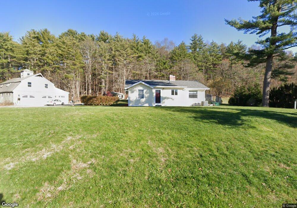
64 Elmwood St Salisbury, MA 01952
Estimated Value: $555,228 - $610,000
2
Beds
1
Bath
1,350
Sq Ft
$434/Sq Ft
Est. Value
About This Home
This home is located at 64 Elmwood St, Salisbury, MA 01952 and is currently estimated at $585,807, approximately $433 per square foot. 64 Elmwood St is a home located in Essex County with nearby schools including Triton Regional High School and Amesbury Seventh-Day Adventist School.
Ownership History
Date
Name
Owned For
Owner Type
Purchase Details
Closed on
Apr 19, 2019
Sold by
Styles Jack A
Bought by
Mendonca-Styles Ft
Current Estimated Value
Purchase Details
Closed on
Oct 30, 1996
Sold by
Robblee Ft and Robblee John L
Bought by
Styles Jack A
Purchase Details
Closed on
Mar 30, 1995
Sold by
Kelley Paul D
Bought by
Perreault Edmund
Purchase Details
Closed on
Jul 6, 1994
Sold by
Bechtel John
Bought by
Kelley Paul D
Purchase Details
Closed on
Feb 20, 1992
Sold by
Kernaghan Robert A
Bought by
Kelley Paul D and Bechtel John F
Create a Home Valuation Report for This Property
The Home Valuation Report is an in-depth analysis detailing your home's value as well as a comparison with similar homes in the area
Home Values in the Area
Average Home Value in this Area
Purchase History
| Date | Buyer | Sale Price | Title Company |
|---|---|---|---|
| Mendonca-Styles Ft | -- | -- | |
| Styles Jack A | $160,000 | -- | |
| Perreault Edmund | $148,000 | -- | |
| Kelley Paul D | $2,000 | -- | |
| Kelley Paul D | $148,500 | -- |
Source: Public Records
Mortgage History
| Date | Status | Borrower | Loan Amount |
|---|---|---|---|
| Previous Owner | Kelley Paul D | $200,000 | |
| Previous Owner | Kelley Paul D | $50,000 |
Source: Public Records
Tax History Compared to Growth
Tax History
| Year | Tax Paid | Tax Assessment Tax Assessment Total Assessment is a certain percentage of the fair market value that is determined by local assessors to be the total taxable value of land and additions on the property. | Land | Improvement |
|---|---|---|---|---|
| 2025 | $4,730 | $469,200 | $169,200 | $300,000 |
| 2024 | $4,746 | $454,200 | $169,200 | $285,000 |
| 2023 | $4,659 | $431,400 | $169,200 | $262,200 |
| 2022 | $4,388 | $393,900 | $154,000 | $239,900 |
| 2021 | $4,343 | $385,700 | $154,000 | $231,700 |
| 2020 | $4,114 | $359,000 | $154,000 | $205,000 |
| 2019 | $4,130 | $348,200 | $154,200 | $194,000 |
| 2018 | $3,913 | $332,200 | $154,200 | $178,000 |
| 2017 | $3,636 | $305,000 | $132,400 | $172,600 |
| 2016 | $3,538 | $303,200 | $125,800 | $177,400 |
| 2015 | $3,330 | $283,400 | $125,600 | $157,800 |
Source: Public Records
Map
Nearby Homes
- 51 Locust St
- 17 Riley Rd
- 22 Maple Ridge Rd
- 462 New Zealand Rd
- 253 Amesbury Rd
- 147 Weare Rd
- 1 Brown Ave Unit 3-80
- 3 Brown Ave Unit 75
- 21 Woodman Rd
- 57 Clinton St
- 100 Congress St
- 3 Glenwood St
- 25 Whittier Meadows Dr
- 2 Locke Hill Ln
- 7 Melrose St
- 95 Lillian Ave
- 105 Market St Unit B
- 103 Market St Unit A
- 103 Market St Unit B
- 101 Market St Unit B
- 3 Ava Mae Ln
- 7 Ava Mae Ln
- 6 Ava Mae Ln
- 40 Blacksnake Rd
- 48 Blacksnake Rd
- 52 Elmwood St
- 42 Blacksnake Rd
- 44 Blacksnake Rd
- 85 Locust St
- 58 Blacksnake Rd
- 46 Elmwood St
- 60 Blacksnake Rd Unit 28 Boa Lane
- 60 Blacksnake Rd Unit 28 Boa
- 72 Coral Ln
- 53 Coral Ln
- 23 Blacksnake Rd
- 3 Adder Ln Unit 3
- 26 Boa Ln
- 66 Coral Ln
- 71 Coral Ln