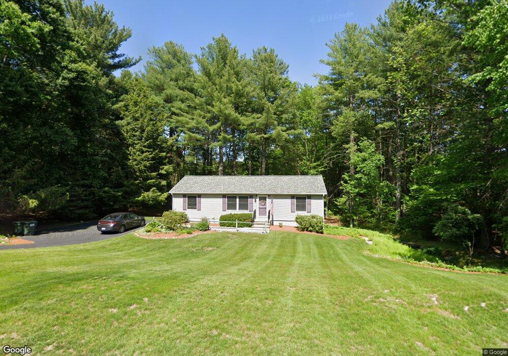
64 Eric Dr Uxbridge, MA 01569
Estimated Value: $510,434 - $549,000
3
Beds
2
Baths
1,728
Sq Ft
$308/Sq Ft
Est. Value
About This Home
This home is located at 64 Eric Dr, Uxbridge, MA 01569 and is currently estimated at $532,609, approximately $308 per square foot. 64 Eric Dr is a home located in Worcester County with nearby schools including Uxbridge High School, Our Lady of the Valley Regional School, and Whitinsville Christian School.
Ownership History
Date
Name
Owned For
Owner Type
Purchase Details
Closed on
Mar 13, 2015
Sold by
Maria Abramo Lt
Bought by
Abramo Ralph J and Abramo Maria
Current Estimated Value
Home Financials for this Owner
Home Financials are based on the most recent Mortgage that was taken out on this home.
Original Mortgage
$200,000
Outstanding Balance
$149,244
Interest Rate
3%
Mortgage Type
Adjustable Rate Mortgage/ARM
Estimated Equity
$383,365
Purchase Details
Closed on
Jan 24, 2008
Sold by
Abramo Maria and Abramo Ralph J
Bought by
Maria Abramo Lt and Abramo Maria
Purchase Details
Closed on
Aug 22, 1996
Sold by
Smith Timothy S and Smith Christine
Bought by
Abramo Ralph and Abramo Maria
Home Financials for this Owner
Home Financials are based on the most recent Mortgage that was taken out on this home.
Original Mortgage
$25,000
Interest Rate
8.4%
Mortgage Type
Purchase Money Mortgage
Create a Home Valuation Report for This Property
The Home Valuation Report is an in-depth analysis detailing your home's value as well as a comparison with similar homes in the area
Home Values in the Area
Average Home Value in this Area
Purchase History
| Date | Buyer | Sale Price | Title Company |
|---|---|---|---|
| Abramo Ralph J | -- | -- | |
| Maria Abramo Lt | -- | -- | |
| Abramo Ralph | $125,000 | -- |
Source: Public Records
Mortgage History
| Date | Status | Borrower | Loan Amount |
|---|---|---|---|
| Open | Abramo Ralph J | $200,000 | |
| Previous Owner | Abramo Ralph | $25,000 |
Source: Public Records
Tax History
| Year | Tax Paid | Tax Assessment Tax Assessment Total Assessment is a certain percentage of the fair market value that is determined by local assessors to be the total taxable value of land and additions on the property. | Land | Improvement |
|---|---|---|---|---|
| 2025 | $55 | $416,600 | $154,000 | $262,600 |
| 2024 | $4,978 | $385,300 | $146,200 | $239,100 |
| 2023 | $4,530 | $324,700 | $126,400 | $198,300 |
| 2022 | $4,322 | $285,100 | $110,700 | $174,400 |
| 2021 | $4,472 | $282,700 | $108,300 | $174,400 |
| 2020 | $4,378 | $261,500 | $106,800 | $154,700 |
| 2019 | $4,485 | $258,500 | $106,800 | $151,700 |
| 2018 | $4,152 | $241,800 | $106,800 | $135,000 |
| 2017 | $3,835 | $226,100 | $104,500 | $121,600 |
| 2016 | $4,020 | $228,800 | $95,800 | $133,000 |
| 2015 | $3,939 | $226,400 | $95,800 | $130,600 |
Source: Public Records
Map
Nearby Homes
- 25 Dunny Cove Ln
- 35 Pouts Ln
- 44 Pouts Ln
- 76 Pouts Ln
- 218 E Hartford Ave Unit 218
- 107 Henry St
- 223 Mendon St
- 3 Strathmore Shire Unit A
- 20 Maple St
- 4 Moon Hill Rd
- 3 Moon Hill Rd
- 13A Asylum St
- 255 Prairie St
- 12 Hartford Ave E
- 597 Mendon Rd
- 55 Northbridge Rd
- 7 Jewell Crossing
- 185 Prairie St
- 27 Taft Ave
- 26 Rivulet St
Your Personal Tour Guide
Ask me questions while you tour the home.