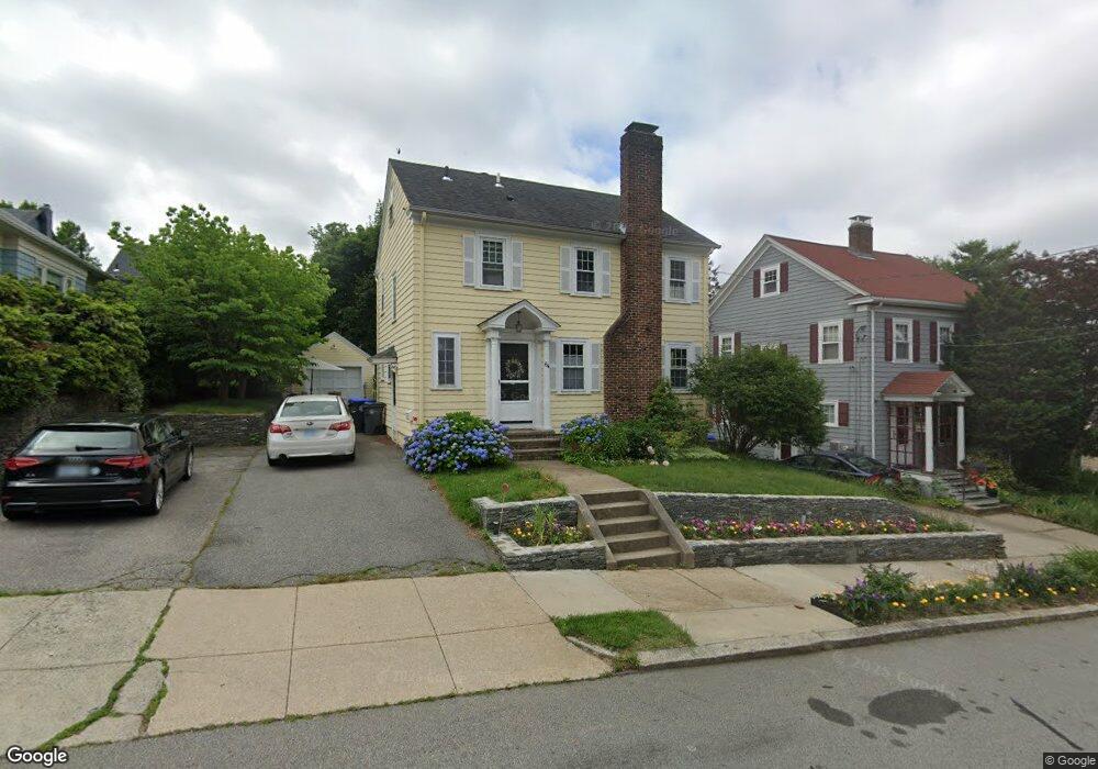
64 Memorial Rd Providence, RI 02906
Estimated Value: $746,365 - $782,000
3
Beds
3
Baths
1,600
Sq Ft
$476/Sq Ft
Est. Value
About This Home
This home is located at 64 Memorial Rd, Providence, RI 02906 and is currently estimated at $762,091, approximately $476 per square foot. 64 Memorial Rd is a home located in Providence County with nearby schools including Asa Messer Elementary School, Charles N. Fortes Elementary School, and Veazie Street Elementary School.
Ownership History
Date
Name
Owned For
Owner Type
Purchase Details
Closed on
Jun 14, 2024
Sold by
Maclnnis Peter P and Maclnnis Elyn G
Bought by
Krishnasamy Mika and Maclnnis Charlotte
Current Estimated Value
Purchase Details
Closed on
Jul 30, 2002
Sold by
Coski Bruce M and Coski Suzanne J
Bought by
Macinnis Peter P and Macinnis Elyn G
Home Financials for this Owner
Home Financials are based on the most recent Mortgage that was taken out on this home.
Original Mortgage
$220,800
Interest Rate
6.73%
Purchase Details
Closed on
Dec 30, 1997
Sold by
Boyle Kenneth J and Antoniello Joyce
Bought by
Coski Bruce M and Coski Suzanne
Create a Home Valuation Report for This Property
The Home Valuation Report is an in-depth analysis detailing your home's value as well as a comparison with similar homes in the area
Home Values in the Area
Average Home Value in this Area
Purchase History
| Date | Buyer | Sale Price | Title Company |
|---|---|---|---|
| Krishnasamy Mika | -- | None Available | |
| Krishnasamy Mika | -- | None Available | |
| Macinnis Peter P | $276,000 | -- | |
| Coski Bruce M | $123,000 | -- | |
| Macinnis Peter P | $276,000 | -- | |
| Coski Bruce M | $123,000 | -- |
Source: Public Records
Mortgage History
| Date | Status | Borrower | Loan Amount |
|---|---|---|---|
| Previous Owner | Coski Bruce M | $85,000 | |
| Previous Owner | Coski Bruce M | $216,000 | |
| Previous Owner | Coski Bruce M | $220,800 |
Source: Public Records
Tax History Compared to Growth
Tax History
| Year | Tax Paid | Tax Assessment Tax Assessment Total Assessment is a certain percentage of the fair market value that is determined by local assessors to be the total taxable value of land and additions on the property. | Land | Improvement |
|---|---|---|---|---|
| 2025 | $5,087 | $605,600 | $370,300 | $235,300 |
| 2024 | $8,709 | $474,600 | $249,500 | $225,100 |
| 2023 | $8,709 | $474,600 | $249,500 | $225,100 |
| 2022 | $8,247 | $463,300 | $249,500 | $213,800 |
| 2021 | $8,638 | $351,700 | $197,400 | $154,300 |
| 2020 | $8,638 | $351,700 | $197,400 | $154,300 |
| 2019 | $8,638 | $351,700 | $197,400 | $154,300 |
| 2018 | $10,000 | $312,900 | $170,900 | $142,000 |
| 2017 | $9,872 | $308,900 | $170,900 | $138,000 |
| 2016 | $9,872 | $308,900 | $170,900 | $138,000 |
| 2015 | $9,175 | $277,200 | $159,500 | $117,700 |
| 2014 | $9,356 | $277,200 | $159,500 | $117,700 |
| 2013 | $9,356 | $277,200 | $159,500 | $117,700 |
Source: Public Records
Map
Nearby Homes
- 202 Rochambeau Ave Unit 2
- 32 Glendale Ave
- 96 Woodbine St
- 98 Evergreen St Unit 2
- 103 Evergreen St
- 873 Hope St
- 31 Peach Ave
- 101 Grand View St Unit 1
- 186 Camp St Unit 5
- 40 Tecumseh St
- 62 Overhill Rd
- 25 Tecumseh St
- 15 Taft Ave
- 94 Larch St
- 640 Elmgrove Ave
- 78 Cypress St
- 62 Harwich Rd
- 41 Wingate Rd
- 7 Mount Hope Ave Unit 310
- 151 Chace Ave