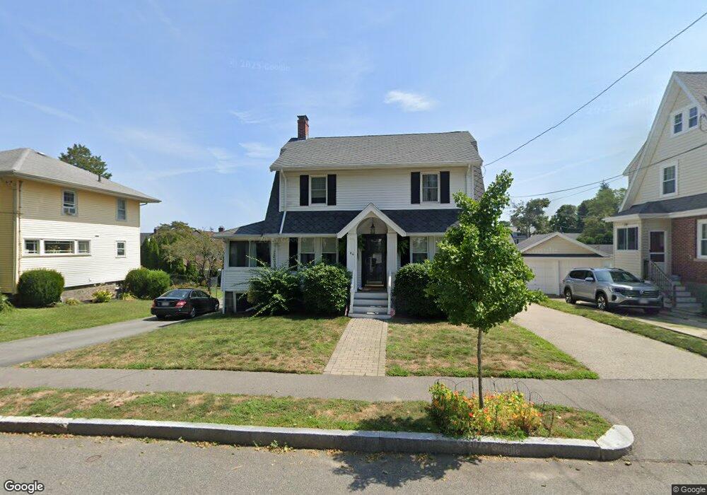
64 Victoria Rd Quincy, MA 02169
Merrymount NeighborhoodEstimated Value: $711,259 - $879,000
3
Beds
1
Bath
1,344
Sq Ft
$601/Sq Ft
Est. Value
About This Home
This home is located at 64 Victoria Rd, Quincy, MA 02169 and is currently estimated at $807,565, approximately $600 per square foot. 64 Victoria Rd is a home located in Norfolk County with nearby schools including Merrymount Elementary School, Broad Meadows Middle School, and Quincy High School.
Ownership History
Date
Name
Owned For
Owner Type
Purchase Details
Closed on
May 31, 2017
Sold by
Ford Michael W and Friree-Ford Stephanie
Bought by
Segal Honor K
Current Estimated Value
Home Financials for this Owner
Home Financials are based on the most recent Mortgage that was taken out on this home.
Original Mortgage
$384,000
Outstanding Balance
$308,298
Interest Rate
2.99%
Mortgage Type
New Conventional
Estimated Equity
$499,267
Purchase Details
Closed on
Aug 31, 2010
Sold by
Ford Michael W and Ford Stacie A
Bought by
Ford Michael W
Home Financials for this Owner
Home Financials are based on the most recent Mortgage that was taken out on this home.
Original Mortgage
$306,000
Interest Rate
4.57%
Mortgage Type
Purchase Money Mortgage
Purchase Details
Closed on
Jun 30, 2004
Sold by
Moran Dina and Moran Vincent
Bought by
Ford Michael W and Ford Stacie A
Home Financials for this Owner
Home Financials are based on the most recent Mortgage that was taken out on this home.
Original Mortgage
$333,700
Interest Rate
6.3%
Mortgage Type
Purchase Money Mortgage
Purchase Details
Closed on
Feb 22, 1999
Sold by
Federman Lise
Bought by
Moran Dina and Moran Vincent
Home Financials for this Owner
Home Financials are based on the most recent Mortgage that was taken out on this home.
Original Mortgage
$183,200
Interest Rate
6.75%
Mortgage Type
Purchase Money Mortgage
Purchase Details
Closed on
Feb 9, 1995
Sold by
Copman Kenneth
Bought by
Federman Lise
Purchase Details
Closed on
Sep 9, 1994
Sold by
Copman Abraham A and Copman Jessie
Bought by
Copman Kenneth
Create a Home Valuation Report for This Property
The Home Valuation Report is an in-depth analysis detailing your home's value as well as a comparison with similar homes in the area
Home Values in the Area
Average Home Value in this Area
Purchase History
| Date | Buyer | Sale Price | Title Company |
|---|---|---|---|
| Segal Honor K | $480,000 | -- | |
| Ford Michael W | -- | -- | |
| Ford Michael W | $440,000 | -- | |
| Moran Dina | $229,000 | -- | |
| Federman Lise | $151,750 | -- | |
| Copman Kenneth | $140,000 | -- |
Source: Public Records
Mortgage History
| Date | Status | Borrower | Loan Amount |
|---|---|---|---|
| Open | Segal Honor K | $384,000 | |
| Previous Owner | Ford Michael W | $306,000 | |
| Previous Owner | Ford Michael W | $333,700 | |
| Previous Owner | Ford Michael W | $62,300 | |
| Previous Owner | Copman Kenneth | $183,200 | |
| Previous Owner | Copman Kenneth | $123,900 |
Source: Public Records
Tax History
| Year | Tax Paid | Tax Assessment Tax Assessment Total Assessment is a certain percentage of the fair market value that is determined by local assessors to be the total taxable value of land and additions on the property. | Land | Improvement |
|---|---|---|---|---|
| 2025 | $7,471 | $648,000 | $343,200 | $304,800 |
| 2024 | $7,162 | $635,500 | $333,200 | $302,300 |
| 2023 | $6,231 | $559,800 | $289,700 | $270,100 |
| 2022 | $5,864 | $489,500 | $241,400 | $248,100 |
| 2021 | $5,834 | $480,600 | $241,400 | $239,200 |
| 2020 | $5,531 | $445,000 | $232,100 | $212,900 |
| 2019 | $5,268 | $419,800 | $216,900 | $202,900 |
| 2018 | $4,910 | $368,100 | $180,100 | $188,000 |
| 2017 | $5,093 | $359,400 | $188,700 | $170,700 |
| 2016 | $4,966 | $345,800 | $185,300 | $160,500 |
| 2015 | $4,706 | $322,300 | $174,800 | $147,500 |
| 2014 | $4,507 | $303,300 | $169,600 | $133,700 |
Source: Public Records
Map
Nearby Homes
- 105 Sea St Unit 105
- 105 Sea St Unit 102
- 25 Moffat Rd
- 11 Plover Rd
- 28 Edgewood Cir
- 96 Utica St
- 20 Whitney Rd Unit 1
- 20 Whitney Rd Unit 6
- 20 Whitney Rd Unit 2
- 1025 Hancock St Unit 6J
- 1025 Hancock St Unit 2K
- 503 Sea St
- 144 Kemper St
- 66 Mcgrath Hwy Unit 302
- 66 Mcgrath Hwy Unit 402
- 66 Mcgrath Hwy Unit 309
- 66 Mcgrath Hwy Unit 201
- 59 Spear St Unit 201
- 59 Spear St Unit 302
- 59 Spear St Unit 402
- 70 Victoria Rd
- 60 Victoria Rd
- 75 Virginia Rd
- 164 Samoset Ave
- 71 Virginia Rd
- 79 Virginia Rd
- 150 Samoset Ave
- 67 Virginia Rd
- 170 Samoset Ave
- 59 Victoria Rd
- 54 Victoria Rd
- 55 Victoria Rd
- 63 Virginia Rd
- 174 Samoset Ave
- 50 Victoria Rd
- 51 Victoria Rd
- 59 Virginia Rd
- 161 Samoset Ave
- 142 Samoset Ave
- 78 Virginia Rd
Your Personal Tour Guide
Ask me questions while you tour the home.