Estimated Value: $285,106 - $321,000
3
Beds
2
Baths
1,694
Sq Ft
$180/Sq Ft
Est. Value
About This Home
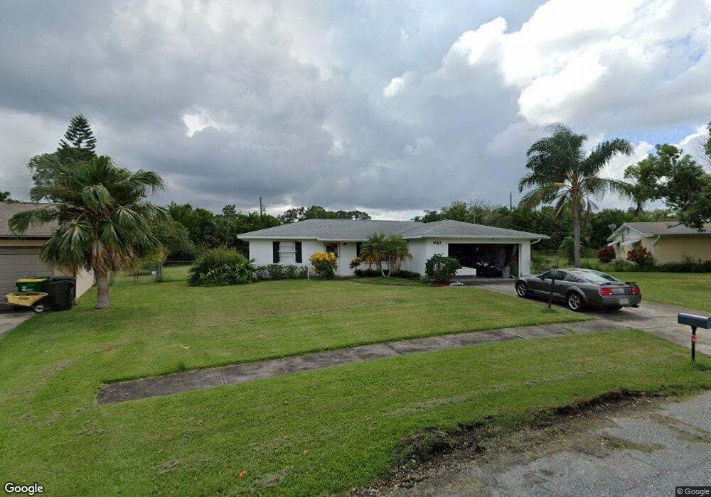
This home is located at 640 Amor Dr, Cocoa, FL 32927 and is currently estimated at $305,527, approximately $180 per square foot. 640 Amor Dr is a home located in Brevard County with nearby schools including Atlantis Elementary School, Space Coast Junior/Senior High School, and East Atlantic Prep of Brevard County.
Ownership History
Date
Name
Owned For
Owner Type
Purchase Details
Closed on
Jul 26, 2019
Sold by
Alpaugh James R
Bought by
Robinson Robert Harold
Current Estimated Value
Home Financials for this Owner
Home Financials are based on the most recent Mortgage that was taken out on this home.
Original Mortgage
$137,464
Outstanding Balance
$120,689
Interest Rate
3.82%
Mortgage Type
FHA
Estimated Equity
$184,838
Purchase Details
Closed on
Feb 27, 2018
Sold by
Alpaugh Albert L and Alpaugh Elizabeth P
Bought by
Allender Steven C
Purchase Details
Closed on
Feb 22, 2018
Sold by
Allender Steven C
Bought by
Alpaugh Albert L and Alpaugh Elizabeth P
Create a Home Valuation Report for This Property
The Home Valuation Report is an in-depth analysis detailing your home's value as well as a comparison with similar homes in the area
Home Values in the Area
Average Home Value in this Area
Purchase History
| Date | Buyer | Sale Price | Title Company |
|---|---|---|---|
| Robinson Robert Harold | $140,000 | Attorney | |
| Allender Steven C | -- | Attorney | |
| Alpaugh Albert L | -- | Attorney |
Source: Public Records
Mortgage History
| Date | Status | Borrower | Loan Amount |
|---|---|---|---|
| Open | Robinson Robert Harold | $137,464 |
Source: Public Records
Tax History
| Year | Tax Paid | Tax Assessment Tax Assessment Total Assessment is a certain percentage of the fair market value that is determined by local assessors to be the total taxable value of land and additions on the property. | Land | Improvement |
|---|---|---|---|---|
| 2025 | $1,595 | $158,980 | -- | -- |
| 2024 | $1,559 | $119,380 | -- | -- |
| 2023 | $1,559 | $115,910 | $0 | $0 |
| 2022 | $1,452 | $112,540 | $0 | $0 |
| 2021 | $1,460 | $109,270 | $0 | $0 |
| 2020 | $1,413 | $107,770 | $40,000 | $67,770 |
| 2019 | $1,745 | $93,740 | $35,000 | $58,740 |
| 2018 | $612 | $39,050 | $0 | $0 |
| 2017 | $598 | $38,250 | $0 | $0 |
| 2016 | $588 | $37,470 | $18,000 | $19,470 |
| 2015 | $581 | $37,210 | $15,000 | $22,210 |
| 2014 | $580 | $36,920 | $11,000 | $25,920 |
Source: Public Records
Map
Nearby Homes
- 645 Altura Dr
- 1131 Covina St
- 1164 Aron St
- 701 Amor Dr
- 780 Alcazar Ave
- 6900 N Highway 1 Unit 6307
- 6900 N Highway 1 Unit 6303
- 6760 N Highway 1 Unit 3204
- 6800 N Highway 1 Unit 4202
- 933 Fay Blvd
- 6340 U S Route 1
- 6340 N Highway 1
- 1050 Barclay Dr
- 7000 N Highway 1 Unit Gg-205
- 7020 U S 1 Unit Ee-202
- 0 Fay Blvd Unit 1011912
- 1040 Jersey St
- 7030 N Highway 1 Unit 101
- 7030 N Highway 1 Unit DD102
- 520 Arabella Ln
Your Personal Tour Guide
Ask me questions while you tour the home.