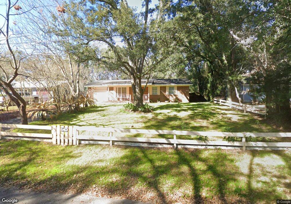
640 Dye St Pensacola, FL 32534
Estimated Value: $172,599 - $219,000
--
Bed
2
Baths
1,050
Sq Ft
$186/Sq Ft
Est. Value
About This Home
This home is located at 640 Dye St, Pensacola, FL 32534 and is currently estimated at $195,400, approximately $186 per square foot. 640 Dye St is a home located in Escambia County with nearby schools including L.D. McArthur Elementary School, Ransom Middle School, and J.M. Tate Senior High School.
Ownership History
Date
Name
Owned For
Owner Type
Purchase Details
Closed on
Oct 19, 2001
Sold by
Cardwell Christopher C and Cardwell Teresa C
Bought by
Mejia Armondo
Current Estimated Value
Home Financials for this Owner
Home Financials are based on the most recent Mortgage that was taken out on this home.
Original Mortgage
$71,326
Outstanding Balance
$27,838
Interest Rate
6.85%
Estimated Equity
$167,562
Purchase Details
Closed on
Nov 1, 1996
Sold by
Kennelly Katy Fay
Bought by
Cardwell Christopher C and Cardwell Teresa C
Home Financials for this Owner
Home Financials are based on the most recent Mortgage that was taken out on this home.
Original Mortgage
$53,579
Interest Rate
8.13%
Mortgage Type
FHA
Create a Home Valuation Report for This Property
The Home Valuation Report is an in-depth analysis detailing your home's value as well as a comparison with similar homes in the area
Home Values in the Area
Average Home Value in this Area
Purchase History
| Date | Buyer | Sale Price | Title Company |
|---|---|---|---|
| Mejia Armondo | $69,900 | -- | |
| Cardwell Christopher C | $54,900 | -- |
Source: Public Records
Mortgage History
| Date | Status | Borrower | Loan Amount |
|---|---|---|---|
| Open | Mejia Armondo | $71,326 | |
| Previous Owner | Cardwell Christopher C | $53,579 |
Source: Public Records
Tax History Compared to Growth
Tax History
| Year | Tax Paid | Tax Assessment Tax Assessment Total Assessment is a certain percentage of the fair market value that is determined by local assessors to be the total taxable value of land and additions on the property. | Land | Improvement |
|---|---|---|---|---|
| 2024 | $608 | $78,998 | -- | -- |
| 2023 | $608 | $76,698 | $0 | $0 |
| 2022 | $589 | $74,465 | $0 | $0 |
| 2021 | $598 | $72,297 | $0 | $0 |
| 2020 | $592 | $71,299 | $0 | $0 |
| 2019 | $588 | $69,696 | $0 | $0 |
| 2018 | $592 | $68,397 | $0 | $0 |
| 2017 | $596 | $66,991 | $0 | $0 |
| 2016 | $597 | $65,614 | $0 | $0 |
| 2015 | $579 | $65,313 | $0 | $0 |
| 2014 | $569 | $64,795 | $0 | $0 |
Source: Public Records
Map
Nearby Homes
- 706 Crooked Oak Dr
- 735 Lexington Rd
- 760 Boulder Creek Dr
- 1046 Fleming Dr
- 1048 Fleming Dr
- 433 Orby St
- 381 Robinson Ln
- 11525 Chemstrand Rd
- 896 Lexington Rd
- 960 Breezy Acres Rd
- 800 Shadow Ridge Dr
- 811 Shadow Ridge Dr
- 901 Shadow Ridge Dr
- 10610 Chemstrand Rd
- 417 Childers St
- 11486 Clear Creek Dr
- 2298 Equestrian Way
- 1504 Muirfield Rd
- 1633 Kinsale Dr
- 525 Northcreek Dr