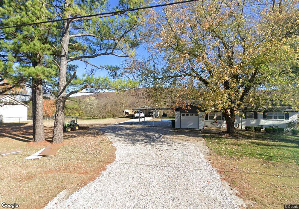
640 Mcknight Ave West Fork, AR 72774
Estimated Value: $212,646 - $258,000
About This Home
This home is located at 640 Mcknight Ave, West Fork, AR 72774 and is currently estimated at $233,662, approximately $237 per square foot. 640 Mcknight Ave is a home located in Washington County with nearby schools including West Fork Elementary School, West Fork Middle School, and West Fork High School.
Ownership History
We collect this data history from publicly available records. To have your information removed, we recommend requesting removal directly through your county’s website.
Purchase Details
Home Financials for this Owner
Home Financials are based on the most recent Mortgage that was taken out on this home.Purchase Details
Purchase Details
Home Values in the Area
Average Home Value in this Area
Purchase History
We collect this data history from publicly available records. To have your information removed, we recommend requesting removal directly through your county’s website.
| Date | Buyer | Sale Price | Title Company |
|---|---|---|---|
| $77,400 | None Available | ||
| -- | -- | ||
| -- | -- |
Mortgage History
We collect this data history from publicly available records. To have your information removed, we recommend requesting removal directly through your county’s website.
| Date | Status | Borrower | Loan Amount |
|---|---|---|---|
| Closed | $78,979 |
Tax History
We collect this data history from publicly available records. To have your information removed, we recommend requesting removal directly through your county’s website.
| Year | Tax Paid | Tax Assessment Tax Assessment Total Assessment is a certain percentage of the fair market value that is determined by local assessors to be the total taxable value of land and additions on the property. | Land | Improvement |
|---|---|---|---|---|
| 2025 | $750 | $36,850 | $10,770 | $26,080 |
| 2024 | $789 | $36,850 | $10,770 | $26,080 |
| 2023 | $812 | $36,850 | $10,770 | $26,080 |
| 2022 | $803 | $25,210 | $5,380 | $19,830 |
| 2021 | $668 | $23,550 | $5,380 | $18,170 |
| 2020 | $620 | $23,550 | $5,380 | $18,170 |
| 2019 | $573 | $17,850 | $4,380 | $13,470 |
| 2018 | $598 | $17,850 | $4,380 | $13,470 |
| 2017 | $571 | $17,850 | $4,380 | $13,470 |
| 2016 | $571 | $17,850 | $4,380 | $13,470 |
| 2015 | $364 | $17,850 | $4,380 | $13,470 |
| 2014 | $364 | $13,835 | $3,030 | $10,805 |
Map
- 735 Mcknight Ave
- 719 W Thornstone Ave
- 326 S Smith St
- 0 W Smith St Unit 1334508
- 327 W Smith St
- 385 W Smith St
- 171 Wheeler St
- 13582 S Highway 170
- 13559 S Highway 170
- 13653 W Mountain Rd
- 14344 Arkansas 170
- 127 Dogwood St
- 73 Elmwood St
- 43 Elmwood St
- 815 James Place
- 14463 S Hwy 170
- 14673 Union Star Rd
- 11 Northwood St
- 66 Northwood St
- TBD Mineral Springs Rd
- 650 Mcknight Ave
- 660 Mcknight Ave
- 649 Mcknight Ave
- 661 Mcknight Ave
- 630 Mcknight Ave
- 631 Mcknight Ave
- 673 Mcknight Ave
- 620 Mcknight Ave
- 688 Mcknight Ave
- 0 Greystone Ave Unit 517568
- 0 Greystone Ave Unit 517740
- 0 Greystone Ave Unit 517742
- 0 Greystone Ave Unit 517745
- 0 Greystone Ave Unit 517752
- 0 Greystone Ave Unit 538358
- 0 Greystone Ave Unit 538350
- 0 Greystone Ave Unit 538355
- 0 Graystone Lot 7 Unit 541102
- 0 Graystone Lot 14 Unit 541104
- 0 Graystone Lot 18 Unit 541105
Ask me questions while you tour the home.