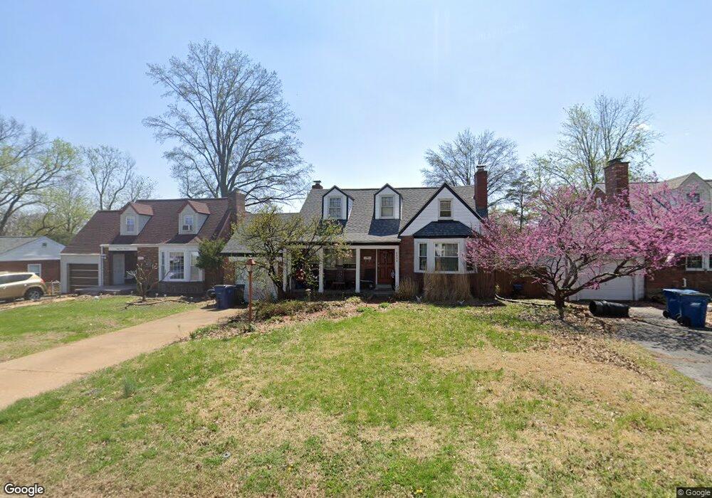
6404 Darlow Dr Saint Louis, MO 63123
Estimated Value: $281,000 - $288,804
2
Beds
2
Baths
1,788
Sq Ft
$160/Sq Ft
Est. Value
About This Home
This home is located at 6404 Darlow Dr, Saint Louis, MO 63123 and is currently estimated at $285,451, approximately $159 per square foot. 6404 Darlow Dr is a home located in St. Louis County with nearby schools including Mesnier Primary School, Gotsch Intermediate School, and Rogers Middle School.
Ownership History
Date
Name
Owned For
Owner Type
Purchase Details
Closed on
Jan 30, 2007
Sold by
Diebold Timothy M and Cunningham Sara C
Bought by
Winkler Aaron D and Winkler Kelley M
Current Estimated Value
Home Financials for this Owner
Home Financials are based on the most recent Mortgage that was taken out on this home.
Original Mortgage
$148,300
Outstanding Balance
$88,578
Interest Rate
6.11%
Mortgage Type
Purchase Money Mortgage
Estimated Equity
$196,873
Purchase Details
Closed on
Mar 13, 2002
Sold by
Freese Genevieve L
Bought by
Diebold Timothy M and Cunningham Sara C
Home Financials for this Owner
Home Financials are based on the most recent Mortgage that was taken out on this home.
Original Mortgage
$113,400
Interest Rate
6.83%
Create a Home Valuation Report for This Property
The Home Valuation Report is an in-depth analysis detailing your home's value as well as a comparison with similar homes in the area
Home Values in the Area
Average Home Value in this Area
Purchase History
| Date | Buyer | Sale Price | Title Company |
|---|---|---|---|
| Winkler Aaron D | $185,436 | None Available | |
| Diebold Timothy M | $126,000 | -- |
Source: Public Records
Mortgage History
| Date | Status | Borrower | Loan Amount |
|---|---|---|---|
| Open | Winkler Aaron D | $148,300 | |
| Previous Owner | Diebold Timothy M | $113,400 |
Source: Public Records
Tax History Compared to Growth
Tax History
| Year | Tax Paid | Tax Assessment Tax Assessment Total Assessment is a certain percentage of the fair market value that is determined by local assessors to be the total taxable value of land and additions on the property. | Land | Improvement |
|---|---|---|---|---|
| 2025 | $3,837 | $50,880 | $15,030 | $35,850 |
| 2024 | $3,837 | $47,330 | $10,010 | $37,320 |
| 2023 | $3,837 | $47,330 | $10,010 | $37,320 |
| 2022 | $3,782 | $41,360 | $10,010 | $31,350 |
| 2021 | $3,451 | $41,360 | $10,010 | $31,350 |
| 2020 | $3,084 | $34,450 | $9,770 | $24,680 |
| 2019 | $3,078 | $34,450 | $9,770 | $24,680 |
| 2018 | $2,474 | $24,430 | $6,800 | $17,630 |
| 2017 | $2,459 | $24,430 | $6,800 | $17,630 |
| 2016 | $2,285 | $24,130 | $5,090 | $19,040 |
| 2015 | $2,295 | $24,130 | $5,090 | $19,040 |
| 2014 | $2,488 | $26,070 | $5,850 | $20,220 |
Source: Public Records
Map
Nearby Homes
- 8554 Palmetto Dr
- 6236 Bixby Ave
- 8505 Ava Dr
- 8740 Brenda Ave
- 8509 Mackenzie Rd
- 6325 Sheppard Dr
- 6211 Bixby Ave
- 6426 Judson Ave
- 8736 New Hampshire Ave
- 9506 Sterling Place
- 9702 Sterling Place
- 8400 New Hampshire Ave
- 6205 MacKenzie Valley Ct
- 6540 Lawnside Dr
- 8942 Eden Ave
- 8613 Carriage Way Dr
- 9347 Mackenzie Rd
- 9127 Coral Dr
- 8348 Vasel Dr
- 8315 Maylor Dr