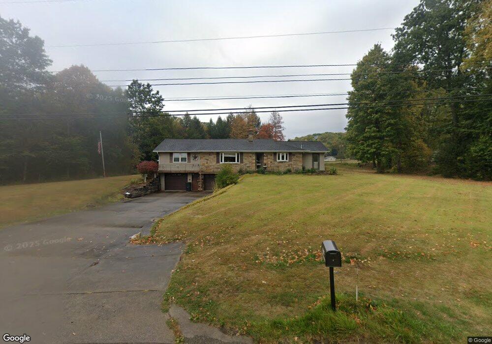
6407 Route 219 Brockport, PA 15823
Estimated Value: $203,985 - $296,000
3
Beds
1
Bath
--
Sq Ft
5.62
Acres
About This Home
This home is located at 6407 Route 219, Brockport, PA 15823 and is currently estimated at $262,246. 6407 Route 219 is a home located in Elk County with nearby schools including Brockway Area Elementary School and Brockway Area Junior/Senior High School.
Ownership History
Date
Name
Owned For
Owner Type
Purchase Details
Closed on
Feb 28, 2017
Sold by
Jessup Gloria M
Bought by
Serafini Larry L and Serafini Lorinda M
Current Estimated Value
Home Financials for this Owner
Home Financials are based on the most recent Mortgage that was taken out on this home.
Original Mortgage
$158,650
Outstanding Balance
$128,218
Interest Rate
4.19%
Mortgage Type
New Conventional
Estimated Equity
$134,028
Create a Home Valuation Report for This Property
The Home Valuation Report is an in-depth analysis detailing your home's value as well as a comparison with similar homes in the area
Home Values in the Area
Average Home Value in this Area
Purchase History
| Date | Buyer | Sale Price | Title Company |
|---|---|---|---|
| Serafini Larry L | $167,000 | None Available |
Source: Public Records
Mortgage History
| Date | Status | Borrower | Loan Amount |
|---|---|---|---|
| Open | Serafini Larry L | $158,650 |
Source: Public Records
Tax History Compared to Growth
Tax History
| Year | Tax Paid | Tax Assessment Tax Assessment Total Assessment is a certain percentage of the fair market value that is determined by local assessors to be the total taxable value of land and additions on the property. | Land | Improvement |
|---|---|---|---|---|
| 2025 | $1,861 | $36,300 | $7,300 | $29,000 |
| 2024 | $1,861 | $36,300 | $7,300 | $29,000 |
| 2023 | $1,797 | $36,300 | $7,300 | $29,000 |
| 2022 | $1,785 | $36,300 | $7,300 | $29,000 |
| 2021 | $1,754 | $36,300 | $7,300 | $29,000 |
| 2020 | $1,754 | $36,300 | $7,300 | $29,000 |
| 2019 | $1,691 | $36,300 | $7,300 | $29,000 |
| 2018 | $1,644 | $36,300 | $7,300 | $29,000 |
| 2017 | $1,595 | $36,300 | $7,300 | $29,000 |
| 2016 | $1,392 | $36,300 | $7,300 | $29,000 |
| 2015 | -- | $36,300 | $7,300 | $29,000 |
| 2013 | -- | $36,300 | $7,300 | $29,000 |
Source: Public Records
Map
Nearby Homes
- 101 Howard Rd
- 3585 Shawmut Rd
- 425 Zuccolotto Ln
- 3323 Mount Daniels Rd
- 1083 Rattlesnake Rd
- 970 Baghdad Rd
- 924 Elm St
- 1549 Main St
- 0 U S 219
- 1074 10th Ave
- 0 Boone Mountain - Heigel Road Rd Unit 4 25-179
- 0 Boone Mountain - Heigel Road Rd Unit 1-2-5-6
- 7956 U S 219
- 166 Kylers Corner Rd
- 601 Sandbank Rd
- 598 Sandbank Rd
- 403 Toby Rd
- 0 Boone Mountain Rd Unit 23-492
- 537 Lynyard Ln Bonefish Rd
- 0 Cap Haitien Rd Unit SEC 17 LOT 14