Estimated Value: $40,000 - $69,000
1
Bed
1
Bath
696
Sq Ft
$78/Sq Ft
Est. Value
About This Home
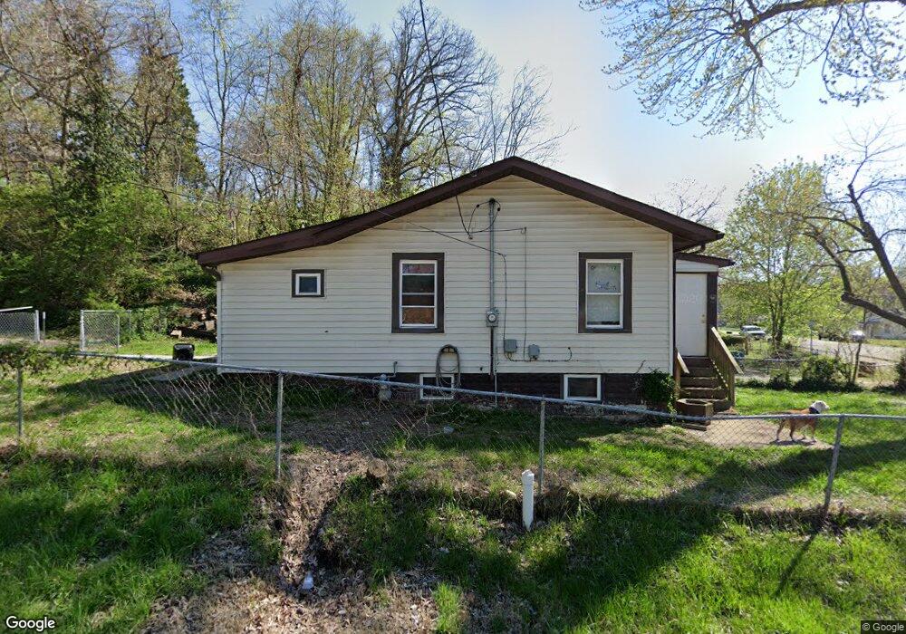
This home is located at 641 Olmstead Way, Alton, IL 62002 and is currently estimated at $54,209, approximately $77 per square foot. 641 Olmstead Way is a home located in Madison County with nearby schools including West Elementary School, Alton Middle School, and Alton High School.
Ownership History
Date
Name
Owned For
Owner Type
Purchase Details
Closed on
Oct 16, 2009
Sold by
Bettorf Robert B
Bought by
Tb Holdings Llc
Current Estimated Value
Home Financials for this Owner
Home Financials are based on the most recent Mortgage that was taken out on this home.
Original Mortgage
$31,500
Interest Rate
6.5%
Mortgage Type
Future Advance Clause Open End Mortgage
Purchase Details
Closed on
Jul 16, 2009
Sold by
Federal National Mortgage Association
Bought by
Bettorf Robert B
Purchase Details
Closed on
Mar 10, 2009
Sold by
Becker Thomas
Bought by
Federal National Mortgage Association
Create a Home Valuation Report for This Property
The Home Valuation Report is an in-depth analysis detailing your home's value as well as a comparison with similar homes in the area
Home Values in the Area
Average Home Value in this Area
Purchase History
| Date | Buyer | Sale Price | Title Company |
|---|---|---|---|
| Tb Holdings Llc | -- | Community Title | |
| Bettorf Robert B | $15,500 | Prairie State Title | |
| Federal National Mortgage Association | -- | None Available |
Source: Public Records
Mortgage History
| Date | Status | Borrower | Loan Amount |
|---|---|---|---|
| Closed | Tb Holdings Llc | $31,500 |
Source: Public Records
Tax History Compared to Growth
Tax History
| Year | Tax Paid | Tax Assessment Tax Assessment Total Assessment is a certain percentage of the fair market value that is determined by local assessors to be the total taxable value of land and additions on the property. | Land | Improvement |
|---|---|---|---|---|
| 2024 | $758 | $9,320 | $640 | $8,680 |
| 2023 | $758 | $8,420 | $580 | $7,840 |
| 2022 | $712 | $7,610 | $520 | $7,090 |
| 2021 | $655 | $7,150 | $490 | $6,660 |
| 2020 | $639 | $6,890 | $470 | $6,420 |
| 2019 | $661 | $6,730 | $460 | $6,270 |
| 2018 | $644 | $6,560 | $450 | $6,110 |
| 2017 | $635 | $6,560 | $450 | $6,110 |
| 2016 | $622 | $6,560 | $450 | $6,110 |
| 2015 | $591 | $6,560 | $450 | $6,110 |
| 2014 | $591 | $6,560 | $450 | $6,110 |
| 2013 | $591 | $6,740 | $460 | $6,280 |
Source: Public Records
Map
Nearby Homes
- 620 Sheppard St
- 809 Maurice St
- 3407 Lincoln St
- 2975 Shady Place
- 3006 Watalee St
- 3410 Bolivar St
- 2933 Forest Dr
- 609 Marsh Ave
- 2828 Residence St
- 1201 Milton Rd
- 2638 Sanford Ave
- 3013 Mayfield Ave
- 2901 Fernwood Ave
- 2701 Watalee St
- 202 Wisconsin Ave
- 200 Sering Ave
- 1215 Clawson St
- 500 Stowell Ave
- 3627 Horn Ave
- 2801 Brown St
- 639 Olmstead Way
- 3100 Block Hillcrest
- 3100 Hillcrest Ave
- 903 Rixon St
- 3205 Hillcrest Ave
- 3108 Hillcrest Ave
- 905 Rixon St
- 905 Rixon St Unit 1/2
- 3107 Hillcrest Ave
- 637 Olmstead Way
- 3201 Duco St
- 905 1/2 Rixon St
- 3105 Hillcrest Ave
- 3207 Hillcrest Ave
- 3203 Duco St
- 700 Fairview Ave
- 3204 Duco St
- 907 Rixon St
- 702 Fairview Ave
- 3103 Hillcrest Ave