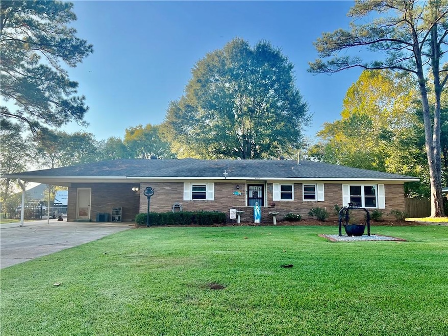
6412 Bouef Trace Unit TA Alexandria, LA 71301
Estimated payment $1,243/month
Highlights
- Popular Property
- RV or Boat Parking
- Granite Countertops
- Alexandria Senior High School Rated A-
- Attic
- Stainless Steel Appliances
About This Home
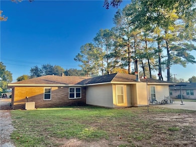
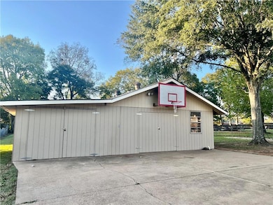
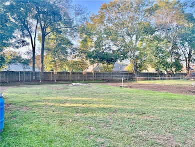
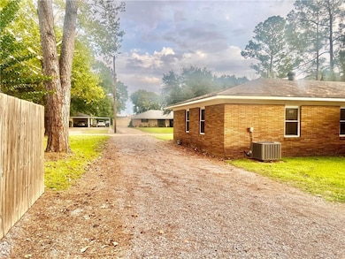
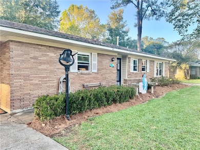
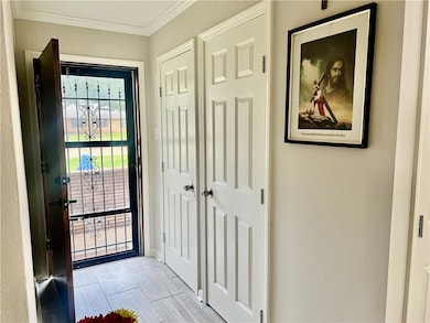
What a magical property! Be out of the city limits on an oversized lot with a 30 x 35 workshop but yet close to everything Alexandria has to offer! Presenting 6412 Bouef Trace, a recently remodeled 3 bedroom, 2 bath ranch style home on a .64 acre lot in a rural development eligible area. This property is NOT in a flood zone. Enter the cozy kitchen/dining combination and fall in love with the new tile, granite island and countertops, new backsplash, and new stainless steel appliances. The extra large living area includes a beautiful wood-burning fireplace just in time for your holiday decor and gatherings. The adjoining laundry area is huge and has enough room for an office or hobby area. You will love your utility bills with the efficiency brought by the recently installed vinyl double paned windows and luxury privacy blinds throughout. And you'll be delighted with how easy it is to clean the tile and luxury vinyl flooring throughout. No carpet! The entire home was repainted 2 years ago in neutral colors and is bright and spacious. The primary bedroom has 2 closets and an en suite bath. Step outside to the extensive outdoor amenities of this property and be impressed with the large patio, extensive concreted area for parking and gatherings, the large shop, small shed, gravel driveway with 30 am camper plug, and gorgeous shaded backyard that backs up to Landmark Subdivision. You will love it here and will forget you are 3 minutes from MacArthur Drive. Schedule your showing today. Magical homes like this are not guaranteed to last!
Home Details
Home Type
- Single Family
Est. Annual Taxes
- $437
Year Built
- Built in 1995
Lot Details
- 0.64 Acre Lot
- Lot Dimensions are 100x276x100x278
- Partially Fenced Property
- Wood Fence
- Oversized Lot
- Property is in very good condition
Home Design
- Brick Exterior Construction
- Slab Foundation
- Shingle Roof
- Vinyl Siding
Interior Spaces
- 1,871 Sq Ft Home
- 1-Story Property
- Ceiling Fan
- Wood Burning Fireplace
- Storm Windows
- Washer and Dryer Hookup
- Attic
Kitchen
- Range
- Microwave
- Dishwasher
- Stainless Steel Appliances
- ENERGY STAR Qualified Appliances
- Granite Countertops
Bedrooms and Bathrooms
- 3 Bedrooms
- 2 Full Bathrooms
Parking
- 2 Car Attached Garage
- Carport
- RV or Boat Parking
Accessible Home Design
- Enhanced Accessible Features
- No Carpet
Eco-Friendly Details
- Energy-Efficient Windows
Outdoor Features
- Stamped Concrete Patio
- Separate Outdoor Workshop
- Shed
Utilities
- Cooling Available
- Heating Available
- Internet Available
Community Details
- Penny Acres Subdivision
Listing and Financial Details
- Assessor Parcel Number 1020123125
Map
Home Values in the Area
Average Home Value in this Area
Tax History
| Year | Tax Paid | Tax Assessment Tax Assessment Total Assessment is a certain percentage of the fair market value that is determined by local assessors to be the total taxable value of land and additions on the property. | Land | Improvement |
|---|---|---|---|---|
| 2024 | $437 | $10,800 | $1,300 | $9,500 |
| 2023 | $1,449 | $10,800 | $1,300 | $9,500 |
| 2022 | $673 | $4,981 | $1,340 | $3,641 |
| 2021 | $591 | $4,981 | $1,340 | $3,641 |
| 2020 | $591 | $4,981 | $1,340 | $3,641 |
| 2019 | $591 | $4,981 | $1,340 | $3,641 |
| 2018 | $0 | $4,981 | $1,340 | $3,641 |
| 2017 | $0 | $4,981 | $1,340 | $3,641 |
| 2016 | $588 | $4,981 | $1,340 | $3,641 |
| 2015 | $588 | $4,981 | $1,340 | $3,641 |
| 2014 | $591 | $4,981 | $1,340 | $3,641 |
| 2013 | $597 | $4,981 | $1,340 | $3,641 |
Property History
| Date | Event | Price | List to Sale | Price per Sq Ft |
|---|---|---|---|---|
| 11/13/2025 11/13/25 | Price Changed | $229,000 | -4.4% | $122 / Sq Ft |
| 10/29/2025 10/29/25 | For Sale | $239,500 | -- | $128 / Sq Ft |
Purchase History
| Date | Type | Sale Price | Title Company |
|---|---|---|---|
| Deed | $120,000 | None Listed On Document |
Mortgage History
| Date | Status | Loan Amount | Loan Type |
|---|---|---|---|
| Open | $110,000 | New Conventional |
Source: Greater Central Louisiana REALTORS® Association
MLS Number: 2528542
APN: 23-004-07320-0022
Disclaimer: Certain information contained herein is derived from information provided by parties other than Homes.com. All information provided is deemed reliable, but is not guaranteed to be accurate and should be independently verified.
![]() IDX information is provided exclusively for personal, non-commercial use, and may not be used for any purpose other than to identify prospective properties consumers may be interested in purchasing. Information is deemed reliable but not guaranteed.
IDX information is provided exclusively for personal, non-commercial use, and may not be used for any purpose other than to identify prospective properties consumers may be interested in purchasing. Information is deemed reliable but not guaranteed.
- 6512 Masonic Dr
- 6301 Bouef Trace Unit TA
- 6501 Tennyson Oaks Ln
- 6142 Masonic Dr
- 6313 Tennyson Oaks Ln
- 1900 Eden Oak Dr
- 6713 Taylor Oaks
- 6412 Tennyson Oaks Ln
- 6400 Genevieve Dr
- 6822 Isabella Dr
- 1805 Horseshoe Dr
- 6910 Isabella Dr
- 5812 Hiawatha Dr
- 2221 Robin Rd
- 5813 Starling Cir
- 6329 Deerfield Dr
- 910 W Shore Dr
- 5721 Courtland Place
- 2016 Horseshoe Dr
- 5828 Jackson Street Extension
- 1704 Horseshoe Dr
- 1704 Horseshoe Dr
- 1704 Horseshoe Dr
- 2145 Horseshoe Dr
- 920 Twin Bridges Rd
- 5703 Jackson St
- 5440 Downing St
- 476 Twin Bridges Rd
- 4400 Queen Elizabeth Ct
- 1307 Windsor Place
- 1247 Macarthur Dr
- 4220 Lee St
- 116 Versailles Blvd Unit A
- 4335 Clubhouse Dr
- 5445 Provine Place
- 616 Macarthur Dr Unit C
- 5936 Provine Place Unit A
- 4051 Bayou Rapides Rd
- 2112 Hill St
- 6656 Coliseum Blvd
