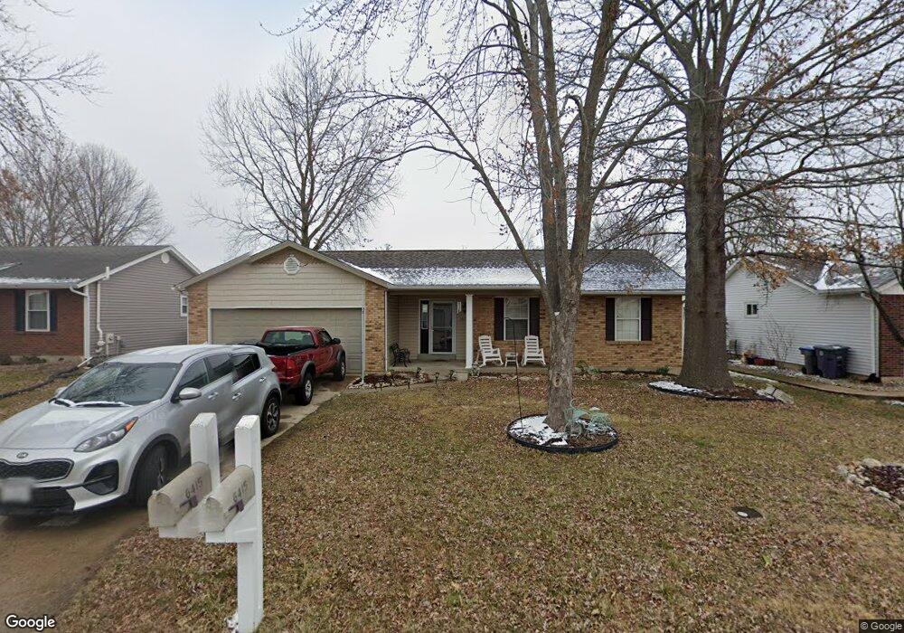
6415 Star Buck Dr O Fallon, MO 63368
Estimated Value: $291,000 - $312,000
3
Beds
2
Baths
1,147
Sq Ft
$265/Sq Ft
Est. Value
About This Home
This home is located at 6415 Star Buck Dr, O Fallon, MO 63368 and is currently estimated at $303,463, approximately $264 per square foot. 6415 Star Buck Dr is a home located in St. Charles County with nearby schools including Pheasant Point Elementary School, Fort Zumwalt South Middle School, and Fort Zumwalt South High School.
Ownership History
Date
Name
Owned For
Owner Type
Purchase Details
Closed on
Aug 5, 2004
Sold by
Arras William S and Arras Julia
Bought by
Riley Ron
Current Estimated Value
Home Financials for this Owner
Home Financials are based on the most recent Mortgage that was taken out on this home.
Original Mortgage
$116,250
Outstanding Balance
$57,647
Interest Rate
6%
Mortgage Type
Purchase Money Mortgage
Estimated Equity
$245,816
Purchase Details
Closed on
Apr 25, 2003
Sold by
Tate Wayne O and Tate Sandra S
Bought by
Arras William S
Purchase Details
Closed on
Apr 27, 2001
Sold by
Vogel Stephen P and Vogel Candice N
Bought by
Tate Wayne O and Tate Sandra S
Home Financials for this Owner
Home Financials are based on the most recent Mortgage that was taken out on this home.
Original Mortgage
$122,035
Interest Rate
6.81%
Mortgage Type
FHA
Create a Home Valuation Report for This Property
The Home Valuation Report is an in-depth analysis detailing your home's value as well as a comparison with similar homes in the area
Home Values in the Area
Average Home Value in this Area
Purchase History
| Date | Buyer | Sale Price | Title Company |
|---|---|---|---|
| Riley Ron | $145,361 | Phoenix Title | |
| Arras William S | -- | -- | |
| Tate Wayne O | -- | -- |
Source: Public Records
Mortgage History
| Date | Status | Borrower | Loan Amount |
|---|---|---|---|
| Open | Riley Ron | $116,250 | |
| Previous Owner | Tate Wayne O | $122,035 | |
| Closed | Riley Ron | $29,050 |
Source: Public Records
Tax History
| Year | Tax Paid | Tax Assessment Tax Assessment Total Assessment is a certain percentage of the fair market value that is determined by local assessors to be the total taxable value of land and additions on the property. | Land | Improvement |
|---|---|---|---|---|
| 2025 | $2,989 | $50,299 | -- | -- |
| 2023 | $2,991 | $45,245 | -- | -- |
| 2022 | $2,561 | $36,059 | $0 | $0 |
| 2021 | $2,568 | $36,059 | $0 | $0 |
| 2020 | $2,457 | $33,225 | $0 | $0 |
| 2019 | $2,463 | $33,225 | $0 | $0 |
| 2018 | $2,397 | $30,928 | $0 | $0 |
| 2017 | $2,355 | $30,928 | $0 | $0 |
| 2016 | $2,041 | $25,743 | $0 | $0 |
| 2015 | $1,903 | $25,743 | $0 | $0 |
| 2014 | $1,962 | $26,184 | $0 | $0 |
Source: Public Records
Map
Nearby Homes
- 703 Tinsley Ct
- 6519 Star Buck Dr
- 531 John Pitman Dr
- 178 Christina Marie Dr
- 174 Christina Marie Dr
- 249 Dardenne Farms Dr
- 1343 Avondale Spring Dr
- 71 Harrisburg Ct
- 101 Winterbrooke Ct
- 112 Auburn Trace Pointe Ct
- 527 Auburn Trace Ln
- 103 Auburn Trace Point
- 1319 Commons Cir
- 10 Muir Trail Ct
- 425 Round Tower Dr W
- 2662 Breckenridge Cir
- 6025 Mo-N Unit # 1
- 3 Royallbend Ct
- 6024 Mo-N Unit #2
- 8020 Cotswald Trail
- 6419 Star Buck Dr
- 6411 Star Buck Dr
- 6416 Sprucefield Dr
- 6420 Sprucefield Dr
- 6412 Sprucefield Dr
- 6423 Star Buck Dr
- 6407 Star Buck Dr
- 6414 Star Buck Dr
- 6418 Star Buck Dr
- 6424 Sprucefield Dr
- 6410 Star Buck Dr
- 6408 Sprucefield Dr
- 6422 Star Buck Dr
- 6427 Star Buck Dr
- 6403 Star Buck Dr
- 6403 Star Buck
- 6428 Sprucefield Dr
- 6406 Star Buck Dr
- 6404 Sprucefield Dr
- 6426 Star Buck Dr
Your Personal Tour Guide
Ask me questions while you tour the home.