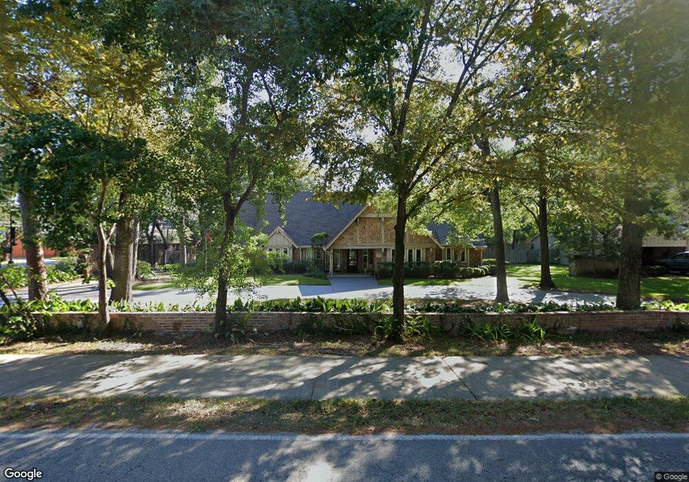
642 Knipp Rd Houston, TX 77024
Estimated Value: $1,720,781 - $2,586,000
5
Beds
5
Baths
4,922
Sq Ft
$418/Sq Ft
Est. Value
About This Home
This home is located at 642 Knipp Rd, Houston, TX 77024 and is currently estimated at $2,056,445, approximately $417 per square foot. 642 Knipp Rd is a home located in Harris County with nearby schools including Bunker Hill Elementary School, Memorial Middle, and Memorial High School.
Ownership History
Date
Name
Owned For
Owner Type
Purchase Details
Closed on
Jun 25, 1999
Sold by
Selzer Alan and Selzer Laurie P
Bought by
Fairbairn James R and Fairbairn Maria J
Current Estimated Value
Home Financials for this Owner
Home Financials are based on the most recent Mortgage that was taken out on this home.
Original Mortgage
$350,000
Outstanding Balance
$84,372
Interest Rate
6%
Estimated Equity
$1,972,073
Create a Home Valuation Report for This Property
The Home Valuation Report is an in-depth analysis detailing your home's value as well as a comparison with similar homes in the area
Home Values in the Area
Average Home Value in this Area
Purchase History
| Date | Buyer | Sale Price | Title Company |
|---|---|---|---|
| Fairbairn James R | -- | Stewart Title |
Source: Public Records
Mortgage History
| Date | Status | Borrower | Loan Amount |
|---|---|---|---|
| Open | Fairbairn James R | $350,000 |
Source: Public Records
Tax History Compared to Growth
Tax History
| Year | Tax Paid | Tax Assessment Tax Assessment Total Assessment is a certain percentage of the fair market value that is determined by local assessors to be the total taxable value of land and additions on the property. | Land | Improvement |
|---|---|---|---|---|
| 2025 | $20,661 | $1,926,589 | $1,022,372 | $904,217 |
| 2024 | $20,661 | $1,523,264 | $953,412 | $569,852 |
| 2023 | $20,661 | $1,540,363 | $904,097 | $636,266 |
| 2022 | $27,478 | $1,384,106 | $871,020 | $513,086 |
| 2021 | $26,018 | $1,201,384 | $802,662 | $398,722 |
| 2020 | $25,483 | $1,150,626 | $792,238 | $358,388 |
| 2019 | $29,271 | $1,268,970 | $823,510 | $445,460 |
| 2018 | $5,758 | $1,133,150 | $886,055 | $247,095 |
| 2017 | $28,297 | $1,238,000 | $886,055 | $351,945 |
| 2016 | $25,725 | $1,300,000 | $886,055 | $413,945 |
| 2015 | $17,369 | $1,321,054 | $886,055 | $434,999 |
| 2014 | $17,369 | $1,100,000 | $766,779 | $333,221 |
Source: Public Records
Map
Nearby Homes
- 711 Timber Hill Dr
- 12 Gage Ct
- 11910 Heritage Ln
- 11718 Broken Bough Cir
- 827 Bunker Hill Rd
- 826 Bunker Hill Rd
- 11905 Barryknoll Ln
- 11729 Joan of Arc Dr
- 11801 Barryknoll Ln
- 11933 Barryknoll Ln
- 601 Strey Ln
- 902 Memorial Village Dr Unit 66
- 939 Memorial Village Dr Unit 38
- 979 Memorial Village Dr Unit 48
- 9 Leisure Ln
- 835 Merridel Rd
- 12003 Tall Oaks St
- 11706 Flintwood Dr
- 12222 Broken Bough Dr
- 12231 Kimberley Ln
- 638 Knipp Rd
- 607 Willowgren Dr
- 11840 Taylorcrest Rd
- 11840 Taylorcrest Rd Unit 14
- 11846 Village Park Cir
- 11842 Taylorcrest Rd
- 11842 Taylorcrest Rd Unit 11
- 11866 Taylorcrest Rd
- 11864 Taylorcrest Rd
- 11844 Taylorcrest Rd
- 11844 Taylorcrest Rd Unit 3
- 11842 Village Park Cir
- 11826 Village Park Cir
- 11862 Taylorcrest Rd
- 11862 Taylorcrest Rd Unit 3
- 634 Knipp Rd
- 11846 Taylorcrest Rd
- 11846 Taylorcrest Rd Unit 13
- 603 Willowgren Dr
- 11860 Taylorcrest Rd