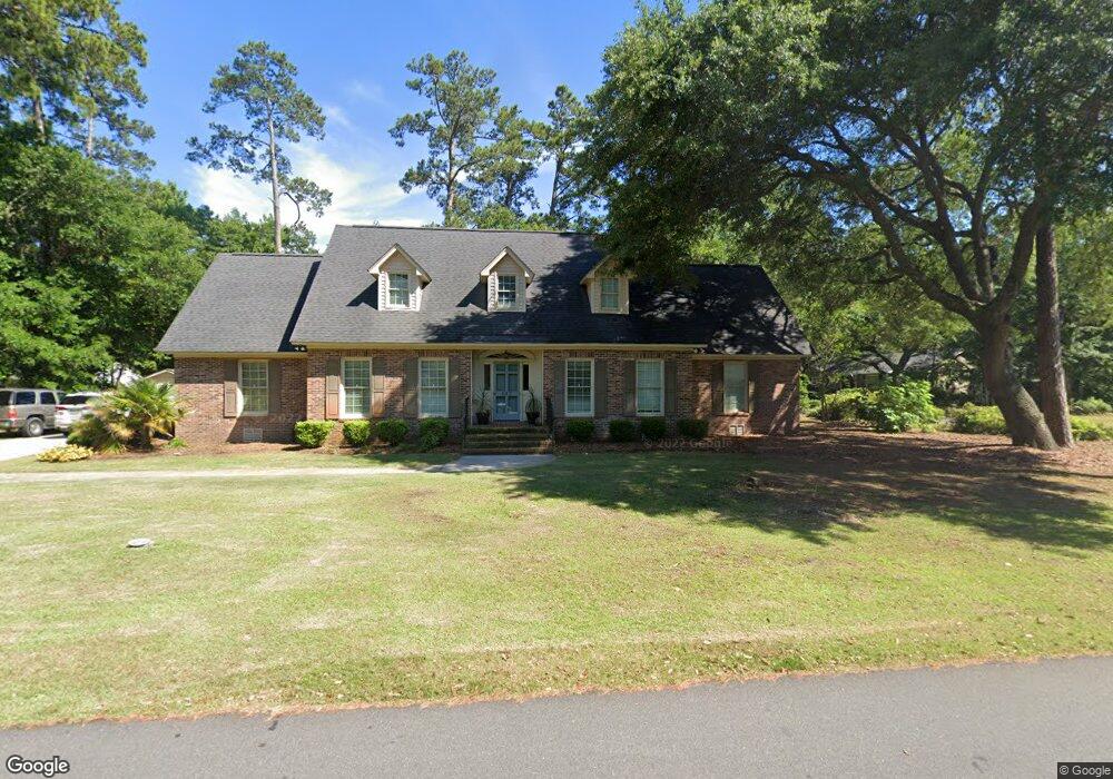
642 Mallard Pond Rd Unit Corner Lot in Mt Gil Murrells Inlet, SC 29576
Estimated Value: $767,000 - $870,705
4
Beds
4
Baths
3,050
Sq Ft
$269/Sq Ft
Est. Value
About This Home
This home is located at 642 Mallard Pond Rd Unit Corner Lot in Mt Gil, Murrells Inlet, SC 29576 and is currently estimated at $819,176, approximately $268 per square foot. 642 Mallard Pond Rd Unit Corner Lot in Mt Gil is a home located in Horry County with nearby schools including Seaside Elementary, St. James Middle School, and St. James Intermediate.
Ownership History
Date
Name
Owned For
Owner Type
Purchase Details
Closed on
Mar 17, 2020
Sold by
Owens David F
Bought by
Bush Anthony L and Bush Jenna M
Current Estimated Value
Home Financials for this Owner
Home Financials are based on the most recent Mortgage that was taken out on this home.
Original Mortgage
$375,250
Outstanding Balance
$332,337
Interest Rate
3.5%
Mortgage Type
New Conventional
Estimated Equity
$486,839
Purchase Details
Closed on
Jun 8, 2000
Sold by
Owens David F and Owens Deborah H
Bought by
Owens David F and Owens Deborah H
Create a Home Valuation Report for This Property
The Home Valuation Report is an in-depth analysis detailing your home's value as well as a comparison with similar homes in the area
Home Values in the Area
Average Home Value in this Area
Purchase History
| Date | Buyer | Sale Price | Title Company |
|---|---|---|---|
| Bush Anthony L | $395,000 | -- | |
| Owens David F | -- | -- |
Source: Public Records
Mortgage History
| Date | Status | Borrower | Loan Amount |
|---|---|---|---|
| Open | Bush Anthony L | $375,250 |
Source: Public Records
Tax History Compared to Growth
Tax History
| Year | Tax Paid | Tax Assessment Tax Assessment Total Assessment is a certain percentage of the fair market value that is determined by local assessors to be the total taxable value of land and additions on the property. | Land | Improvement |
|---|---|---|---|---|
| 2024 | $6,386 | $26,509 | $11,780 | $14,729 |
| 2023 | $6,386 | $23,344 | $8,758 | $14,586 |
| 2021 | $5,551 | $15,563 | $5,839 | $9,724 |
| 2020 | $1,668 | $16,291 | $5,839 | $10,452 |
| 2019 | $1,668 | $16,291 | $5,839 | $10,452 |
| 2018 | $0 | $12,788 | $5,308 | $7,480 |
| 2017 | $1,173 | $12,788 | $5,308 | $7,480 |
| 2016 | -- | $12,788 | $5,308 | $7,480 |
| 2015 | $1,173 | $12,788 | $5,308 | $7,480 |
| 2014 | $1,030 | $12,788 | $5,308 | $7,480 |
Source: Public Records
Map
Nearby Homes
- 855 Riven Oak Dr Unit Mt. Gilead-Horry Cou
- 592 Trizzie Trail
- 571 Fernwood Rd
- 598 Rum Gully Rd
- 596 Trizzie Trail
- 510 Rum Gully Rd
- 425 E Surfwind Dr
- 429 E Surfwind Dr Unit Lot 47
- 40 Shamrock Cir
- 34 Shamrock Cir
- 1 Seaway Ln
- 527 Mount Gilead Rd
- 106 Edward Ave
- 14 Shamrock Cir
- 2 Keel Ln
- 422 Vereen Rd
- 181 Offshore Dr
- 636 N Creekside Dr
- 17 Offshore Dr
- 465 Vereen Rd Unit 10
- 642 Mallard Pond Rd
- 642 Mallard Pond Rd
- 642 Mallard Pond Rd Unit Mt Gilead Brick Ranc
- 642 Mallard Pond Rd
- 852 Riven Oak Dr
- 656 Mallard Pond Rd
- 622 Mallard Pond Rd
- 855 Riven Oak Dr Unit Mt. Gilead
- 855 Riven Oak Dr
- 851 Sawmill Rd
- 633 Mallard Pond Rd
- 659 Mallard Pond Rd
- 659 Mallard Pond Rd
- 840 Riven Oak Dr
- 843 Riven Oak Dr
- 621 Mallard Pond Rd
- 839 Sawmill Rd
- 858 Mount Gilead Rd
- 856 Sawmill Rd
- 846 Mount Gilead Rd