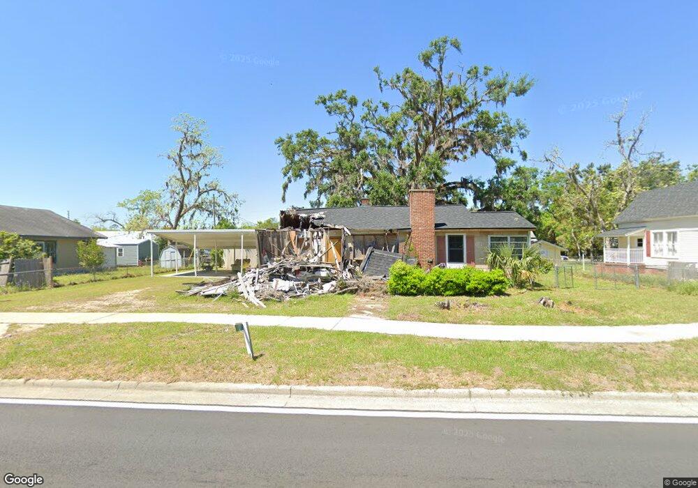
642 SW Range Ave Madison, FL 32340
Estimated Value: $119,000 - $139,000
Studio
--
Bath
1,393
Sq Ft
$93/Sq Ft
Est. Value
About This Home
This home is located at 642 SW Range Ave, Madison, FL 32340 and is currently estimated at $129,220, approximately $92 per square foot. 642 SW Range Ave is a home located in Madison County with nearby schools including Madison County Central School, Madison County High School, and James Madison Preparatory Charter High School.
Ownership History
Date
Name
Owned For
Owner Type
Purchase Details
Closed on
Apr 2, 2013
Sold by
Burnette Carlton M
Bought by
Solomon Arche B and Solomon Shernita
Current Estimated Value
Home Financials for this Owner
Home Financials are based on the most recent Mortgage that was taken out on this home.
Original Mortgage
$47,000
Interest Rate
7%
Mortgage Type
Seller Take Back
Purchase Details
Closed on
Mar 22, 2010
Sold by
Burnette Carlton M
Bought by
Burnette Carlton M
Create a Home Valuation Report for This Property
The Home Valuation Report is an in-depth analysis detailing your home's value as well as a comparison with similar homes in the area
Home Values in the Area
Average Home Value in this Area
Purchase History
| Date | Buyer | Sale Price | Title Company |
|---|---|---|---|
| Solomon Arche B | $50,000 | Attorney | |
| Burnette Carlton M | -- | Attorney |
Source: Public Records
Mortgage History
| Date | Status | Borrower | Loan Amount |
|---|---|---|---|
| Closed | Solomon Arche B | $47,000 |
Source: Public Records
Tax History
| Year | Tax Paid | Tax Assessment Tax Assessment Total Assessment is a certain percentage of the fair market value that is determined by local assessors to be the total taxable value of land and additions on the property. | Land | Improvement |
|---|---|---|---|---|
| 2025 | $64 | $3,016 | $2,680 | $336 |
| 2024 | $319 | $3,016 | $2,680 | $336 |
| 2023 | $319 | $39,352 | $0 | $0 |
| 2022 | $298 | $38,206 | $0 | $0 |
| 2021 | $281 | $37,093 | $0 | $0 |
| 2020 | $271 | $36,581 | $0 | $0 |
| 2019 | $253 | $35,759 | $2,680 | $33,079 |
| 2018 | $256 | $35,759 | $0 | $0 |
| 2017 | $0 | $35,339 | $2,680 | $32,659 |
| 2016 | $374 | $40,386 | $2,680 | $37,706 |
| 2015 | $381 | $40,424 | $2,680 | $37,744 |
| 2014 | $382 | $40,461 | $0 | $0 |
Source: Public Records
Map
Nearby Homes
- 135 SE Oak St
- 191 SW Crosby Ave
- 155 SE Madison St
- 313 SW Horry Ave
- 201 SE Pride St
- 235 SW Valentine Ave
- 0 SE Stephens Ave Unit 383830
- 137 SE Old County Camp Rd
- 000 Highway 90
- 0 Martin Luther King jr Dr Unit MFRTB8389203
- 225 SW Lee Ave
- 1137 Florida 14
- 348 SW Brookwood Ave
- 178 Duval St
- 334 W Base St
- 319 SE Bunker St
- 277 SE Woodlawn St
- 0 Vacant Sw Jeanette Cir
- 590 NE Colin Kelly Hwy
- TBD SW Harvey Greene Dr
- 658 SW Range Ave
- 620 SW Range Ave
- 641 SW Horry Ave
- 623 SW Horry Ave Unit 1
- 623 SW Horry Ave
- 663 SW Horry Ave
- 600 SW Range Ave
- 611 SW Range Ave
- 682 SW Range Ave
- 674 SW Range Ave
- 603 SW Horry Ave
- 643 SW Range Ave
- 683 SW Horry Ave
- 692 SW Range Ave
- 616 SW Horry Ave
- 27.50 ac Cr 14 Unit 1
- 582 SW Range Ave
- TBD Florida 14
- 706 SW Range Ave
- 598 SW Horry Ave
Your Personal Tour Guide
Ask me questions while you tour the home.