NOT LISTED FOR SALE

642 W Kinman Rd SW Calhoun, GA 30701

Estimated Value: $598,000

48 Acres
$12,350 Price per Acre
2,109,175 Sq Ft Lot

Last Sold October 12, 2022

Last sale price $450,000 $586 Per Sq Ft

Est. 33% increase in value since last sale

Current estimated payment $3,346/month

134 Days on Market

Highlights

  • 1,500 Feet of Waterfront
  • 48.42 Acre Lot
  • Partially Wooded Lot
  • Home fronts a creek
  • Creek On Lot
  • Corner Lot

About This Lot

As of October 2022

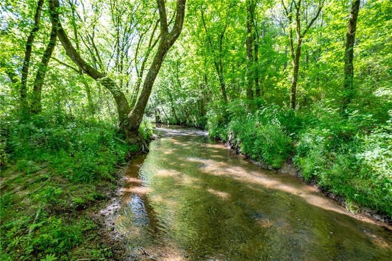
Looking for water? YEAR ROUND CREEK runs through this rare find of farm land. Some beautiful hilltop home sites near W. Kinman Road or above the creek. Come explore this farm with historic roots. The early settlers' log cabin was removed from this site and relocated to New Echota State Park. A mix of level and hills, open field and the privacy of woods. The land is bordered by W. Kinman on the north and Hwy 53 on the west. Perfect for livestock with fencing in place and plenty of water. An outdoorsman's paradise full of deer, turkey and more. A wonderful place to raise a family - Convenient to Calhoun, Rome and Adairsville, less than 10 mins from I-75.

Last Agent to Sell the Property

Beth Maddox

Century 21 The Avenues License #171740 Listed on: 05/03/2022

Century 21 The Avenues

Last Buyer's Agent

Larhonda Johnson

Flipper McDaniel & Assoicates License #326891

Property Details

Property Type

  • Land

Est. Annual Taxes

  • $714

Year Built

  • 1960

Lot Details

  • 48.42 Acre Lot
  • Lot Dimensions are 1500 x 1600
  • Home fronts a creek
  • 1,500 Feet of Waterfront
  • Property fronts a highway
  • Barbed Wire
  • Corner Lot
  • Cleared Lot
  • Partially Wooded Lot
  • Landscaped with Trees
  • Grass Covered Lot
  • Property is zoned A1

Property Views

  • Water
  • Woods
  • Rural

Location

  • Property is near schools
  • Property is near shops

Schools

  • Swain Elementary School
  • Ashworth Middle School
  • Gordon Central High School

Utilities

  • Phone Available

Listing and Financial Details

  • Assessor Parcel Number 026 043

Community Details

Overview

  • Stream

Recreation

  • Creek On Lot
  • Spring on Lot
  • Wetlands on Lot

Property Details

Property Type

Land

Est. Annual Taxes

$714

Year Built

1960

Lot Details

0

Listing Details

  • Standard Status: Closed
  • Legal Description: To be provided by Terry Brumlow, PC after survey is completed. Portion of 026-043 being on the east side of Highway 53, approx 48 acres+/-
  • Property Type: Land
  • MLS Status: Closed
  • Property Sub Type: Unimproved Land
  • Current Classification: Undeveloped/Zoned Agriculture
  • Restrictions Requirements: Easements
  • Special Features: None
  • Year Built: 1960

Property Details

  • Property: Land

Exterior Features

  • Waterfront Frontage: 1500
  • Fencing: Barbed Wire
  • View: Rural, Trees/Woods, Water

Utilities

  • Utilities: Electricity Available, Phone Available, Water Available

Condo/Co-op/Association

  • Community Features: Near Schools, Near Shopping, Stream Year Round

Schools

  • Elementary School: Swain
  • Middle School: Ashworth
  • High School: Gordon Central

Lot Info

  • Acres: 48.4200
  • Timber: Mixed
  • Land/Lot: 57
  • Possible Use: Agricultural, Cattle, Farm, Horses, Hunting, Recreational, Residential
  • Section G M D: 3
  • Current Zoning: A1
  • Current Use: Agricultural, Vacant
  • Lot Features: Corner Lot, Creek On Lot, Spring On Lot, Wetlands
  • Lot Dimensions: 1500 x 1600
  • Parcel Number: 026 043
  • Price Acre Dollar: 9293.68
  • Horse Amenities: None
  • Property Attached Yn: No

Tax Info

  • Taxes: 714.00
  • Assessor Parcel Number: 026-043A
  • Additional Assessor Parcel Numbers: 026-043
  • Close Date: 2022-10-12
  • Tax Year: 2021

Multi Family

  • Waterfront Features: Creek

MLS Schools

  • School Bus Route Elem: Yes
  • School Bus Route High: Yes
  • School Bus Route Middle: Yes
  • Elementary School: Swain
  • High School: Gordon Central
  • Middle School: Ashworth

Ownership History

Date Name Owned For Owner Type

Purchase Details

Listed on
May 3, 2022
Closed on
Oct 12, 2022
Sold by
Lewis John F
Bought by
Sims Joel and Sims Family Rev Liv Tr
Seller's Agent
Beth Maddox
Century 21 The Avenues
Buyer's Agent
Larhonda Johnson
Flipper McDaniel & Assoicates
List Price
$499,000
Sold Price
$450,000
Premium/Discount to List
-$49,000
-9.82%
Total Days on Market
134
Views
10
Current Estimated Value
$598,000

Home Financials for this Owner

Home Financials are based on the most recent Mortgage that was taken out on this home.
Estimated Appreciation
$148,000

Purchase Details

Closed on
Dec 6, 2017
Sold by
Lewis Clare Harlan
Bought by
Lewis John Franklin and Lewis Joyce K

Purchase Details

Closed on
Dec 5, 2017
Sold by
Ballard Mignon F
Bought by
Lewis John F
Source: Public Records

Similar Property in Calhoun, GA

  • 00 Resaca Lafayette Rd, Calhoun, GA 30701

    $698,680

    • Land
    • 39 Acres
    • $17,819 per Acre
    • 00 Resaca Lafayette Rd
    • Calhoun, GA

    Extraordinary Development Opportunity - Prime Acreage for Sale! Calling all Developers, Investors, and Buyers! Don't miss out on this exceptional opportunity to acquire a large tract of land with unparalleled potential. Situated just a stone's throw from I-75 (Exit 320 - Flying J), and perfectly positioned between Chattanooga and Atlanta, this expansive 14.03 AC parcel, along with an

    Cynthia Weiser Keller Williams Realty Signature Partners

    Section Image

Range of Values:

Collateral Analytics

Collateral Analytics Collateral Analytics AVMs (Automated Valuation Model) employ a number of statistical approaches combined with neighborhood-specific comparable selection guarantees the most up-to-date and precise valuations.

Not Available

Collateral Analytics does not have data for the current month. Please view the chart for historical values.

ICE

ICE Mortgage Technology ICE Mortgage Technology’s AVM (Automated Valuation Model) is a state-of-the-art online residential property valuation tool that provides a quick and accurate estimate of the value of almost any home in the U.S.

Not Available

ICE Mortgage Technology does not have data for the current month. Please view the chart for historical values.

First American

First American First American Data & Analytics’ next-generation AVM combines unrivaled data assets with a blended ensemble of valuation models to produce highly accurate, reliable valuations you can trust.

Not Available

First American does not have data for the current month. Please view the chart for historical values.

Quantarium

Quantarium Quantarium’s valuation service, repeatedly proven the industry’s most accurate and comprehensive, is supercharged with a self-learning and auto-tuning AI engine that continually becomes smarter and more accurate as it processes daily inputs from the industry’s leading RE data lake.

Not Available

Quantarium does not have data for the current month. Please view the chart for historical values.

Average Value
Not Available
List Price
Sold Price
Create a Home Valuation Report for This Property
The Home Valuation Report is an in-depth analysis detailing your home's value as well as a comparison with similar homes in the area

Home Values in the Area

Source: Public Records

Average Home Value in this Area


Source: Public Records

Purchase History

Date Buyer Sale Price Title Company
Sims Joel $450,000 --
Lewis John Franklin $50,000 --
Lewis John Franklin -- --
Lewis Clare Harlan -- --
Ballard Mignon Franklin -- --
Lewis John F -- --
Source: Public Records

Property History

Date Event Price Change Sq Ft Price
10/12/2022 10/12/22 Sold $450,000 -9.8% $586 / Sq Ft
09/14/2022 09/14/22 Pending -- -- --
05/03/2022 05/03/22 For Sale $499,000 -- $650 / Sq Ft
Source: First Multiple Listing Service (FMLS)

Tax History Compared to Growth

Source: Public Records

Tax History

Year Tax Paid Tax Assessment Tax Assessment Total Assessment is a certain percentage of the fair market value that is determined by local assessors to be the total taxable value of land and additions on the property. Land Improvement
2023 $61 $2,400 $2,400 $0
2022 $61 $2,400 $2,400 $0
2021 $67 $2,400 $2,400 $0
2020 $69 $2,400 $2,400 $0
2019 $311 $10,800 $2,400 $8,400
2018 $297 $10,320 $2,400 $7,920
2017 $290 $9,800 $2,400 $7,400
2016 $291 $9,800 $2,400 $7,400
2015 $289 $9,640 $2,400 $7,240
2014 $269 $9,221 $2,424 $6,797
Source: Public Records

Agents Affiliated with this Home

  • Section Image
  • Section Image
See All Agents

Map

Source: First Multiple Listing Service (FMLS)

MLS Number: 7036477

First Multiple Listing Service (FMLS)

APN: 026-043A