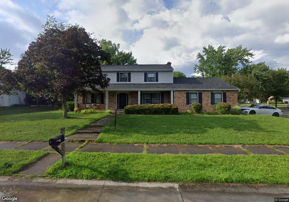
6421 Wayoata Ct Fort Wayne, IN 46815
Blackhawk NeighborhoodEstimated Value: $280,000 - $307,872
4
Beds
3
Baths
2,608
Sq Ft
$114/Sq Ft
Est. Value
About This Home
This home is located at 6421 Wayoata Ct, Fort Wayne, IN 46815 and is currently estimated at $296,218, approximately $113 per square foot. 6421 Wayoata Ct is a home located in Allen County with nearby schools including Glenwood Park Elementary School, Blackhawk Middle School, and R Nelson Snider High School.
Ownership History
Date
Name
Owned For
Owner Type
Purchase Details
Closed on
Aug 30, 2001
Sold by
Kearney Timothy R and Kearney Virginia K
Bought by
Mccormick Christopher M and Mccormick Janetta F
Current Estimated Value
Create a Home Valuation Report for This Property
The Home Valuation Report is an in-depth analysis detailing your home's value as well as a comparison with similar homes in the area
Home Values in the Area
Average Home Value in this Area
Purchase History
| Date | Buyer | Sale Price | Title Company |
|---|---|---|---|
| Mccormick Christopher M | -- | -- |
Source: Public Records
Tax History Compared to Growth
Tax History
| Year | Tax Paid | Tax Assessment Tax Assessment Total Assessment is a certain percentage of the fair market value that is determined by local assessors to be the total taxable value of land and additions on the property. | Land | Improvement |
|---|---|---|---|---|
| 2024 | $3,201 | $296,100 | $29,900 | $266,200 |
| 2023 | $3,201 | $280,200 | $29,900 | $250,300 |
| 2022 | $3,001 | $265,400 | $29,900 | $235,500 |
| 2021 | $2,546 | $227,000 | $23,100 | $203,900 |
| 2020 | $2,331 | $213,100 | $23,100 | $190,000 |
| 2019 | $2,121 | $195,300 | $23,100 | $172,200 |
| 2018 | $1,950 | $178,900 | $23,100 | $155,800 |
| 2017 | $1,958 | $178,100 | $23,100 | $155,000 |
| 2016 | $1,793 | $165,800 | $23,100 | $142,700 |
| 2014 | $1,542 | $149,500 | $23,100 | $126,400 |
| 2013 | $1,554 | $150,800 | $23,100 | $127,700 |
Source: Public Records
Map
Nearby Homes
- 6918 Piegan Place
- 7286 Starks (Lot 11) Blvd
- 7342 Starks (Lot 8) Blvd
- 3307 Arrowwood Dr
- 3210 Arrowwood Dr
- 5914 Vance Ave
- 7109 Antebellum Dr
- 3322 Blackfoot Ct
- 7107 Piegan Place
- 2924 Seafarer Cove
- 5717 Bayside Dr
- 7138 Antebellum Blvd
- 5720 Bayside Dr
- 3711 Bobolink Crossover
- 7117 Blackhawk Ln
- 5723 Port Royal
- 3409 Worchester Place
- 2528 E Saint Thomas Point
- 3707 Well Meadow Place
- 6601 Bennington Dr
- 3221 Kenaston Dr
- 6405 Wayoata Ct
- 6424 Wayoata Ct
- 6420 Papago Ct
- 3204 Kenaston Dr
- 6430 Papago Ct
- 6331 Wayoata Ct
- 3126 Kenaston Dr
- 6406 Wayoata Ct
- 3210 Kenaston Dr
- 3115 Kenaston Dr
- 3115 Kenaston Dr Unit 323
- 3218 Kenaston Dr
- 3116 Kenaston Dr
- 6326 Papago Ct
- 6330 Wayoata Ct
- 6325 Wayoata Ct
- 3230 Kenaston Dr
- 3121 SiMcOe Ct
- 6431 Papago Ct