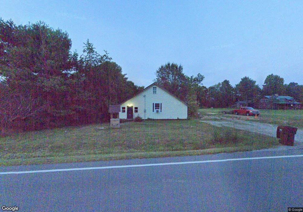
6424 Us Highway 50 Hillsboro, OH 45133
Estimated Value: $168,942 - $193,000
3
Beds
1
Bath
1,284
Sq Ft
$141/Sq Ft
Est. Value
About This Home
This home is located at 6424 Us Highway 50, Hillsboro, OH 45133 and is currently estimated at $181,486, approximately $141 per square foot. 6424 Us Highway 50 is a home located in Highland County with nearby schools including Hillsboro Primary School, Hillsboro Middle School, and Hillsboro High School.
Ownership History
Date
Name
Owned For
Owner Type
Purchase Details
Closed on
Nov 25, 1998
Sold by
Rosselott Craig C
Bought by
Norris Joseph R and Norris Deborah L
Current Estimated Value
Home Financials for this Owner
Home Financials are based on the most recent Mortgage that was taken out on this home.
Original Mortgage
$56,700
Outstanding Balance
$12,846
Interest Rate
6.75%
Mortgage Type
New Conventional
Estimated Equity
$168,640
Purchase Details
Closed on
Mar 8, 1994
Bought by
Hitchcock Clarence W
Create a Home Valuation Report for This Property
The Home Valuation Report is an in-depth analysis detailing your home's value as well as a comparison with similar homes in the area
Home Values in the Area
Average Home Value in this Area
Purchase History
| Date | Buyer | Sale Price | Title Company |
|---|---|---|---|
| Norris Joseph R | $63,000 | -- | |
| Hitchcock Clarence W | $55,500 | -- |
Source: Public Records
Mortgage History
| Date | Status | Borrower | Loan Amount |
|---|---|---|---|
| Open | Norris Joseph R | $56,700 |
Source: Public Records
Tax History Compared to Growth
Tax History
| Year | Tax Paid | Tax Assessment Tax Assessment Total Assessment is a certain percentage of the fair market value that is determined by local assessors to be the total taxable value of land and additions on the property. | Land | Improvement |
|---|---|---|---|---|
| 2024 | $1,112 | $33,150 | $8,930 | $24,220 |
| 2023 | $1,112 | $27,690 | $7,910 | $19,780 |
| 2022 | $1,026 | $27,690 | $7,910 | $19,780 |
| 2021 | $982 | $27,690 | $7,910 | $19,780 |
| 2020 | $808 | $22,160 | $6,340 | $15,820 |
| 2019 | $788 | $22,160 | $6,340 | $15,820 |
| 2018 | $714 | $22,160 | $6,340 | $15,820 |
| 2017 | $677 | $19,010 | $7,040 | $11,970 |
| 2016 | $678 | $19,010 | $7,040 | $11,970 |
| 2015 | $646 | $17,400 | $7,040 | $10,360 |
| 2014 | $682 | $17,400 | $7,040 | $10,360 |
| 2013 | $683 | $17,400 | $7,040 | $10,360 |
Source: Public Records
Map
Nearby Homes
- 6279 Riber Rd
- 7049 Pea Ridge Ct
- 6805 Pea Ridge Rd
- 147 W Main St
- 122 Westover Dr
- 116 Meadow Ln
- 129 Lanewood Dr
- 63 Willettsville Pike
- 6195 State Route 124
- 0 Highway 50 Unit 1857481
- 515 S Elm St
- 702 Cheryl Ln
- 701 S Elm St
- 227 W South St
- 331 S West St
- 7615 Pea Ridge Rd Unit B
- 7615 Pea Ridge Rd Unit A
- 7615 Pea Ridge Rd
- 129 Vaughn Ave
- 7619 Pea Ridge Rd Unit A
- 6408 Us Highway 50
- 6408 Us Rt 50
- 6408 U S 50
- 6405 Us Highway 50
- 6438 Us Highway 50
- 6438 U S 50
- 6435 Us Highway 50
- 6341 Us Highway 50
- 6359 Us Highway 50
- 6359 Us Highway 50
- 6311 Us Highway 50
- 6478 Riber Rd
- 6456 Riber Rd
- 6420 Riber Rd
- 6455 Riber Rd
- 6455 Riber Rd
- 6275 Us Highway 50
- 6390 Riber Rd
- 6265 Us Highway 50
- 6265 Us Highway 50