6430 Bankside Dr Unit 12 Houston, TX 77096
Brays Oaks NeighborhoodHighlights
- Traditional Architecture
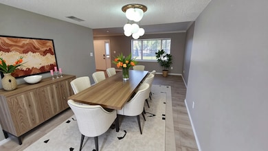
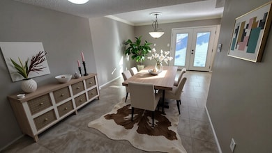
- Breakfast Room
- Courtyard
- Community Pool
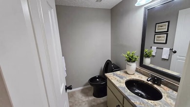
- Bathtub with Shower
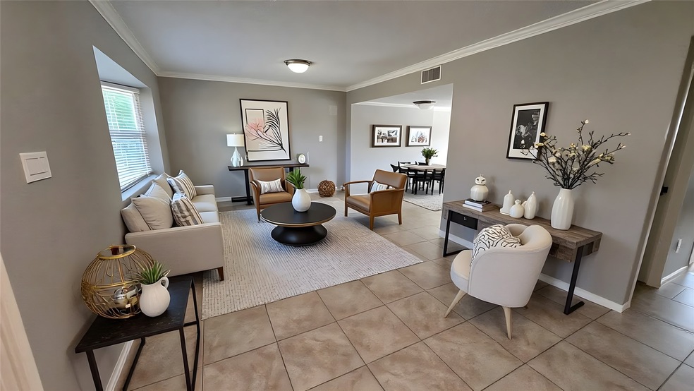
- Living Room
About This Home
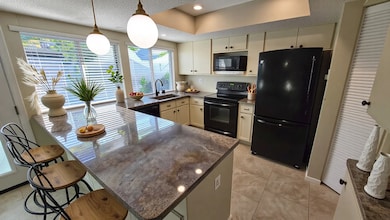
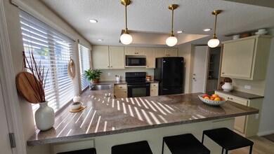
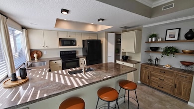
This stunning four-bedroom, two-and-a-half bathroom townhouse, located in a gated community, boasts fresh paint, a spacious living room that flows seamlessly into the dining room, an appealing kitchen equipped with a granite countertop and refrigerator, and generously sized bedrooms with laminate flooring. The property also features an enclosed patio space and a two-car carport. The community offers a swimming pool and playground for residents to enjoy.

Townhouse Details
Home Type
- Townhome
Year Built
- Built in 1972
Home Design
- Traditional Architecture
Interior Spaces
- 1,725 Sq Ft Home
- 2-Story Property
- Ceiling Fan
- Living Room
- Breakfast Room
Kitchen
- Electric Oven
- Electric Range
- Free-Standing Range
- Microwave
- Dishwasher
- Disposal
Flooring
- Carpet
- Laminate
- Tile
Bedrooms and Bathrooms
- 4 Bedrooms
- Bathtub with Shower
Laundry
- Dryer
- Washer
Parking
- 2 Detached Carport Spaces
- Additional Parking
- Assigned Parking
Schools
- Halpin/Tinsley Elementary School
- Fondren Middle School
- Westbury High School
Utilities
- Central Heating and Cooling System
- Cable TV Available
Additional Features
- ENERGY STAR Qualified Appliances
- Courtyard
- 1,788 Sq Ft Lot
Listing and Financial Details
- Property Available on 11/3/25
- 12 Month Lease Term
Community Details
Recreation
- Community Pool
Pet Policy
- Call for details about the types of pets allowed
- Pet Deposit Required
Additional Features
- Northbrook Village Ph 01 Subdivision
- Card or Code Access
Map
Property History
| Date | Event | Price | List to Sale | Price per Sq Ft | Prior Sale |
|---|---|---|---|---|---|
| 11/03/2025 11/03/25 | For Rent | $1,800 | 0.0% | -- | |
| 10/31/2025 10/31/25 | Sold | -- | -- | -- | View Prior Sale |
| 10/01/2025 10/01/25 | Pending | -- | -- | -- | |
| 09/25/2025 09/25/25 | For Sale | $149,950 | -- | $87 / Sq Ft |
Source: Houston Association of REALTORS®
MLS Number: 82284911
APN: 1048010000002
Disclaimer: Certain information contained herein is derived from information provided by parties other than Homes.com. All information provided is deemed reliable, but is not guaranteed to be accurate and should be independently verified.
![]() Copyright 2025, Houston REALTORS® Information Service, Inc.
Copyright 2025, Houston REALTORS® Information Service, Inc.
The information provided is exclusively for consumers’ personal, non-commercial use, and may not be used for any purpose other than to identify prospective properties consumers may be interested in purchasing.
Information is deemed reliable but not guaranteed.
- 6432 Bankside Dr
- 6331 Creekbend Dr Unit 88
- 10763 Sandpiper Dr
- 6370 Creekbend Dr Unit 55
- 6354 Creekbend Dr Unit 104
- 6330 Creekbend Dr Unit D
- 10631 Sandpiper Dr
- 10930 Bob White Dr
- 6335 Portal Dr
- 6215 Portal Dr
- 6103 Portal Dr
- 6115 Lymbar Dr
- 10110 Bob White Dr
- 0 Braewick Dr
- 6214 Yarwell Dr
- 6206 Yarwell Dr
- 6110 Yarwell Dr
- 7703 Braesridge Ct
- 7618 Twin Hills Dr
- 6030 Warm Springs Rd
- 6416 Bankside Dr Unit 42
- 10806 Bob White Dr
- 10813 Sandpiper Dr
- 10813 Sandpiper Dr Unit 176
- 10721 Sandpiper Dr Unit 162
- 6425 Bankside Dr
- 6358 Creekbend Dr Unit 102
- 6330 Creekbend Dr Unit D
- 10930 Bob White Dr
- 6215 Portal Dr
- 10402 Sandpiper Dr
- 10301 Sandpiper Dr
- 6215 Cheena Dr
- 10734 Glenfield Ct
- 6026 Willowbend Blvd
- 6023 Claridge Dr
- 6400 W Bellfort Ave
- 7703 Braesridge Ct
- 7610 Burning Hills Dr
- 11403 Braewick Dr