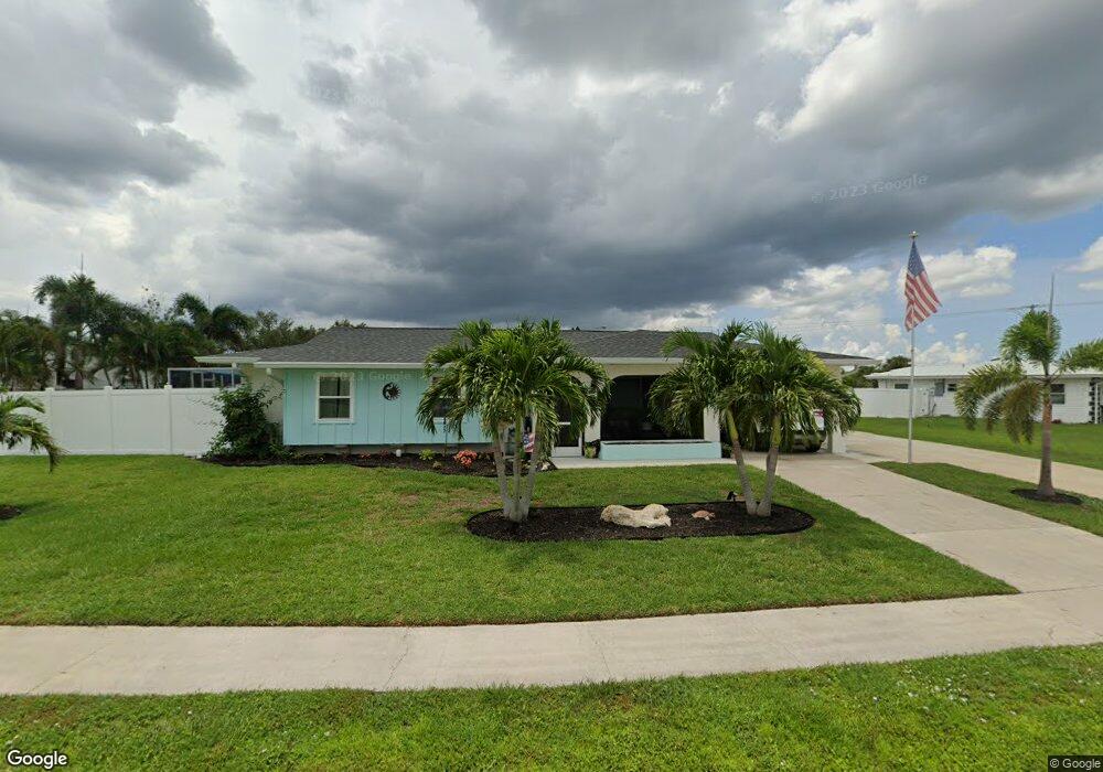
6433 Fabian Rd North Port, FL 34287
Estimated Value: $236,000 - $263,000
3
Beds
2
Baths
1,166
Sq Ft
$210/Sq Ft
Est. Value
About This Home
This home is located at 6433 Fabian Rd, North Port, FL 34287 and is currently estimated at $244,766, approximately $209 per square foot. 6433 Fabian Rd is a home located in Sarasota County with nearby schools including North Port High School, Lamarque Elementary School, and Heron Creek Middle School.
Ownership History
Date
Name
Owned For
Owner Type
Purchase Details
Closed on
May 26, 2016
Sold by
Daly Paul and Daly Linda
Bought by
Mcconaha Douglas R and Mcconaha Peggy Ann
Current Estimated Value
Home Financials for this Owner
Home Financials are based on the most recent Mortgage that was taken out on this home.
Original Mortgage
$76,000
Outstanding Balance
$60,527
Interest Rate
3.59%
Mortgage Type
New Conventional
Estimated Equity
$184,239
Purchase Details
Closed on
Oct 30, 2012
Sold by
Dallas G W and Dallas Nicole
Bought by
Daly Paul and Daly Linda
Create a Home Valuation Report for This Property
The Home Valuation Report is an in-depth analysis detailing your home's value as well as a comparison with similar homes in the area
Home Values in the Area
Average Home Value in this Area
Purchase History
| Date | Buyer | Sale Price | Title Company |
|---|---|---|---|
| Mcconaha Douglas R | $152,000 | Alliance Group Title Llc | |
| Daly Paul | $75,000 | Attorney |
Source: Public Records
Mortgage History
| Date | Status | Borrower | Loan Amount |
|---|---|---|---|
| Open | Mcconaha Douglas R | $76,000 |
Source: Public Records
Tax History Compared to Growth
Tax History
| Year | Tax Paid | Tax Assessment Tax Assessment Total Assessment is a certain percentage of the fair market value that is determined by local assessors to be the total taxable value of land and additions on the property. | Land | Improvement |
|---|---|---|---|---|
| 2024 | $2,608 | $172,302 | -- | -- |
| 2023 | $2,608 | $173,344 | $0 | $0 |
| 2022 | $2,533 | $170,404 | $0 | $0 |
| 2021 | $2,325 | $142,022 | $0 | $0 |
| 2020 | $2,270 | $137,287 | $0 | $0 |
| 2019 | $2,204 | $133,185 | $0 | $0 |
| 2018 | $2,087 | $131,618 | $0 | $0 |
| 2017 | $2,014 | $125,500 | $13,500 | $112,000 |
| 2016 | $2,067 | $111,600 | $7,500 | $104,100 |
| 2015 | $1,724 | $72,800 | $6,500 | $66,300 |
| 2014 | $1,622 | $60,200 | $0 | $0 |
Source: Public Records
Map
Nearby Homes
- 6483 Fabian Rd
- 6365 Scorpio Ave
- 6698 Acmar Ct
- 6424 Elmwood Rd
- 6912 Kenwood Dr
- 6383 S Biscayne Dr
- 6103 Fabian Rd
- 6282 Morning Ave
- 7509 Mesa St
- 7518 Lyncrest St
- 0997160030 Bolander Terrace
- 35 Lino Rd
- 34 Lino Rd
- 33 Lino Rd
- 32 Lino Rd
- 6127 Otis Rd
- 7959 Hyde Park Ave
- 6655 Pan American Blvd
- 6382 Talbot St
- 6355 Freemont St
- 6393 Fabian Rd
- 6614 S Biscayne Dr
- 6630 S Biscayne Dr
- 6375 Road
- 6422 Fabian Rd
- 6442 Fabian Rd
- 6375 Fabian Rd
- 6402 Fabian Rd
- 6642 S Biscayne Dr
- 6462 Fabian Rd
- 6382 Fabian Rd
- 6482 Fabian Rd
- 6654 S Biscayne Dr
- 6359 Fabian Rd
- 6498 Fabian Rd
- 6362 Fabian Rd
- 6670 S Biscayne Dr
- 6343 Fabian Rd
- 6658 Kenwood Dr