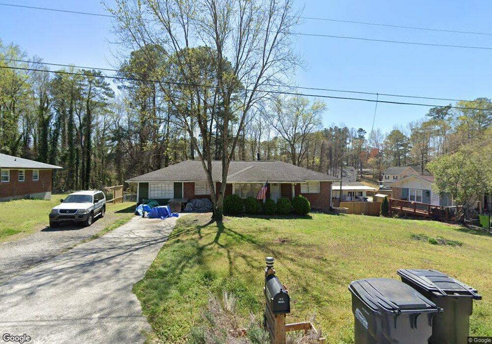
6435 Wanda Ln Austell, GA 30168
Estimated Value: $187,000 - $300,000
3
Beds
2
Baths
1,100
Sq Ft
$223/Sq Ft
Est. Value
About This Home
This home is located at 6435 Wanda Ln, Austell, GA 30168 and is currently estimated at $245,454, approximately $223 per square foot. 6435 Wanda Ln is a home located in Cobb County with nearby schools including Bryant Elementary School, Lindley Middle School, and Pebblebrook High School.
Ownership History
Date
Name
Owned For
Owner Type
Purchase Details
Closed on
Mar 29, 2007
Sold by
Mangrum Anthony
Bought by
Sears Danien and Sears Stephanie
Current Estimated Value
Home Financials for this Owner
Home Financials are based on the most recent Mortgage that was taken out on this home.
Original Mortgage
$111,233
Outstanding Balance
$65,727
Interest Rate
6.1%
Mortgage Type
FHA
Estimated Equity
$179,727
Purchase Details
Closed on
Mar 30, 2005
Sold by
Yale Mtg Corp
Bought by
Mangrum Anthony
Purchase Details
Closed on
Jan 4, 2005
Sold by
Watts Patrisha B
Bought by
Yale Mortgage Corp
Purchase Details
Closed on
Nov 25, 2003
Sold by
Ms Mortgage Services Llc
Bought by
Watts Patrisha B
Home Financials for this Owner
Home Financials are based on the most recent Mortgage that was taken out on this home.
Original Mortgage
$13,510
Interest Rate
5.98%
Mortgage Type
Stand Alone Refi Refinance Of Original Loan
Purchase Details
Closed on
Jan 27, 1998
Sold by
Mcdowell Albert C
Bought by
Watts Patrisha B
Home Financials for this Owner
Home Financials are based on the most recent Mortgage that was taken out on this home.
Original Mortgage
$57,539
Interest Rate
7.14%
Mortgage Type
FHA
Create a Home Valuation Report for This Property
The Home Valuation Report is an in-depth analysis detailing your home's value as well as a comparison with similar homes in the area
Home Values in the Area
Average Home Value in this Area
Purchase History
| Date | Buyer | Sale Price | Title Company |
|---|---|---|---|
| Sears Danien | $112,500 | -- | |
| Mangrum Anthony | $88,000 | -- | |
| Yale Mortgage Corp | $93,178 | -- | |
| Watts Patrisha B | $30,200 | -- | |
| Watts Patrisha B | $59,000 | -- |
Source: Public Records
Mortgage History
| Date | Status | Borrower | Loan Amount |
|---|---|---|---|
| Open | Sears Danien | $111,233 | |
| Previous Owner | Watts Patrisha B | $13,510 | |
| Previous Owner | Watts Patrisha B | $57,539 |
Source: Public Records
Tax History
| Year | Tax Paid | Tax Assessment Tax Assessment Total Assessment is a certain percentage of the fair market value that is determined by local assessors to be the total taxable value of land and additions on the property. | Land | Improvement |
|---|---|---|---|---|
| 2025 | $2,946 | $97,776 | $18,000 | $79,776 |
| 2024 | $2,948 | $97,776 | $18,000 | $79,776 |
| 2023 | $2,948 | $97,776 | $18,000 | $79,776 |
Source: Public Records
Map
Nearby Homes
- 1151 S Gordon Rd
- 6445 Sherwood Trail
- 6559 Brandemere Way
- 6563 Brandemere Way
- 1784 Brandemere Dr Unit 3
- 1920 Silver Creek Dr Unit 4
- 1972 Cox Dr Unit 5
- 1576 S Gordon Rd
- 1961 Abbey Province
- 6595 Malvin Dr
- 6651 Malvin Dr
- 6182 Grove Crest Way Unit 3
- 1531 Withmoor Terrace
- 1541 Withmoor Terrace
- 6718 Roscommon Dr
- 6496 Drake Manor
- 6486 Drake Manor
- 6488 Drake Manor
- 6708 S Dillon Rd
- 1405 Dillon Rd
Your Personal Tour Guide
Ask me questions while you tour the home.