Estimated Value: $231,699 - $284,000
3
Beds
1
Bath
1,830
Sq Ft
$146/Sq Ft
Est. Value
About This Home
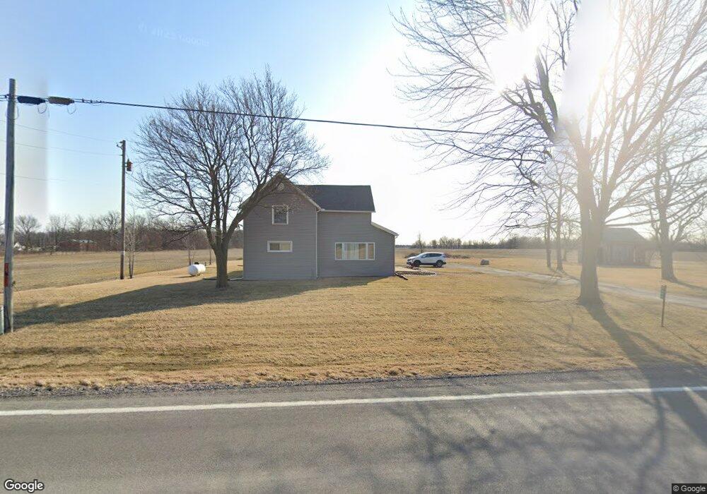
This home is located at 644 State Route 235, Ada, OH 45810 and is currently estimated at $267,175, approximately $145 per square foot. 644 State Route 235 is a home located in Hardin County with nearby schools including Ada Elementary School and Ada High School.
Ownership History
Date
Name
Owned For
Owner Type
Purchase Details
Closed on
Jun 22, 2020
Sold by
Kidd Kristina and Faurot Derek
Bought by
Cronin Cassi J and Knapchaefer Randy S
Current Estimated Value
Home Financials for this Owner
Home Financials are based on the most recent Mortgage that was taken out on this home.
Original Mortgage
$158,340
Outstanding Balance
$140,356
Interest Rate
3.2%
Mortgage Type
New Conventional
Estimated Equity
$126,819
Purchase Details
Closed on
Dec 29, 2016
Sold by
Simon Properties Llc
Bought by
Kidd Kristina and Faurot Derek
Home Financials for this Owner
Home Financials are based on the most recent Mortgage that was taken out on this home.
Original Mortgage
$146,400
Interest Rate
3.94%
Mortgage Type
New Conventional
Purchase Details
Closed on
Dec 28, 2004
Bought by
Williams Terry L and Gove Richard S
Purchase Details
Closed on
Dec 8, 2000
Bought by
Keeler Floyd F Revoc Tru
Purchase Details
Closed on
Jan 20, 1989
Create a Home Valuation Report for This Property
The Home Valuation Report is an in-depth analysis detailing your home's value as well as a comparison with similar homes in the area
Home Values in the Area
Average Home Value in this Area
Purchase History
| Date | Buyer | Sale Price | Title Company |
|---|---|---|---|
| Cronin Cassi J | $174,000 | First Lima Title Agency | |
| Kidd Kristina | $145,000 | Superior Title | |
| Williams Terry L | $70,000 | -- | |
| Keeler Floyd F Revoc Tru | $236,000 | -- | |
| -- | -- | -- |
Source: Public Records
Mortgage History
| Date | Status | Borrower | Loan Amount |
|---|---|---|---|
| Open | Cronin Cassi J | $158,340 | |
| Previous Owner | Kidd Kristina | $146,400 |
Source: Public Records
Tax History Compared to Growth
Tax History
| Year | Tax Paid | Tax Assessment Tax Assessment Total Assessment is a certain percentage of the fair market value that is determined by local assessors to be the total taxable value of land and additions on the property. | Land | Improvement |
|---|---|---|---|---|
| 2024 | $2,176 | $58,520 | $9,400 | $49,120 |
| 2023 | $2,176 | $58,520 | $9,400 | $49,120 |
| 2022 | $2,032 | $47,510 | $4,800 | $42,710 |
| 2021 | $2,287 | $47,510 | $4,800 | $42,710 |
| 2020 | $2,261 | $47,510 | $4,800 | $42,710 |
| 2019 | $1,999 | $42,510 | $4,590 | $37,920 |
| 2018 | $1,956 | $42,510 | $4,590 | $37,920 |
| 2017 | $3,637 | $42,510 | $4,590 | $37,920 |
| 2016 | $1,153 | $26,200 | $4,060 | $22,140 |
| 2015 | $1,149 | $26,850 | $4,060 | $22,790 |
| 2014 | $3,148 | $26,850 | $4,060 | $22,790 |
| 2013 | $1,257 | $27,020 | $4,060 | $22,960 |
Source: Public Records
Map
Nearby Homes
- 3769 County Road 304
- 629 N Main St
- 128 W North Ave
- 444 Edwards St Unit A, B
- 444 Edwards St Unit 2
- 442 Edwards St
- 210 N Gilbert St
- 211 S Main St
- 212 N Simon St
- 211 W Buckeye Ave Unit 211 1/2
- 22694 County Road 12
- 301 S Main St
- 308-310 S Simon St
- 3600 Township Road 27
- 314 E University Ave
- 710 S Main St
- 4071 Township Road 35
- 00 Lincoln Hwy
- 20515 County Road 15
- 2864 Ohio 309
- 644 State Route 235
- 0644 St Route
- 564 State Route 235
- 564 State Route 235
- 589 State Route 235
- 0664 St Route
- 787 State Route 235
- 447 Ohio 235
- 447 State Route 235
- 447 State Route 235
- 447 State Route 235
- 416 State Route 235
- 478 State Route 235
- 2859 County Road 20
- 546 State Route 235
- 356 State Route 235
- 2913 County Rd
- 2913 Cr