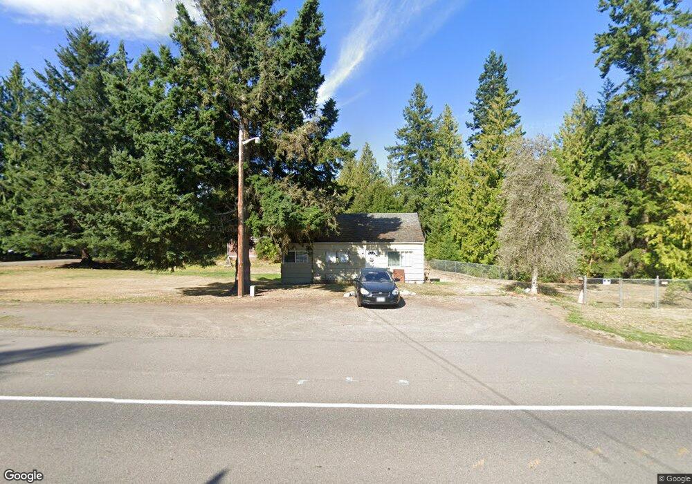
6443 State Route 20 Port Townsend, WA 98368
Estimated Value: $222,006 - $449,000
2
Beds
1
Bath
680
Sq Ft
$541/Sq Ft
Est. Value
About This Home
This home is located at 6443 State Route 20, Port Townsend, WA 98368 and is currently estimated at $368,002, approximately $541 per square foot. 6443 State Route 20 is a home located in Jefferson County with nearby schools including Salish Coast Elementary School, Blue Heron Middle School, and Port Townsend High School.
Ownership History
Date
Name
Owned For
Owner Type
Purchase Details
Closed on
May 31, 2017
Sold by
Tyler Pamela A and Tyler Larry Joseph
Bought by
Tyler Pamela Ann and Meyer Joshua A
Current Estimated Value
Home Financials for this Owner
Home Financials are based on the most recent Mortgage that was taken out on this home.
Original Mortgage
$144,900
Outstanding Balance
$120,361
Interest Rate
3.97%
Mortgage Type
New Conventional
Estimated Equity
$247,641
Purchase Details
Closed on
Apr 26, 2012
Sold by
Moore Jeanne M and Bell Art
Bought by
Anibas Raymond J
Create a Home Valuation Report for This Property
The Home Valuation Report is an in-depth analysis detailing your home's value as well as a comparison with similar homes in the area
Home Values in the Area
Average Home Value in this Area
Purchase History
| Date | Buyer | Sale Price | Title Company |
|---|---|---|---|
| Tyler Pamela Ann | -- | Jefferson Title Company Inc | |
| Anibas Raymond J | -- | None Available |
Source: Public Records
Mortgage History
| Date | Status | Borrower | Loan Amount |
|---|---|---|---|
| Open | Tyler Pamela Ann | $144,900 |
Source: Public Records
Tax History Compared to Growth
Tax History
| Year | Tax Paid | Tax Assessment Tax Assessment Total Assessment is a certain percentage of the fair market value that is determined by local assessors to be the total taxable value of land and additions on the property. | Land | Improvement |
|---|---|---|---|---|
| 2024 | $1,037 | $118,134 | $75,900 | $42,234 |
| 2023 | $1,037 | $111,077 | $67,200 | $43,877 |
| 2022 | $827 | $98,888 | $59,000 | $39,888 |
| 2021 | $814 | $79,608 | $49,390 | $30,218 |
| 2020 | $817 | $73,745 | $44,900 | $28,845 |
| 2019 | $770 | $72,371 | $44,900 | $27,471 |
| 2018 | $773 | $72,371 | $44,900 | $27,471 |
| 2017 | $669 | $64,529 | $41,030 | $23,499 |
| 2016 | $608 | $58,663 | $37,300 | $21,363 |
| 2015 | $606 | $58,663 | $37,300 | $21,363 |
| 2014 | -- | $58,663 | $37,300 | $21,363 |
| 2013 | -- | $58,665 | $37,300 | $21,365 |
Source: Public Records
Map
Nearby Homes
- 9999 S Discovery Rd
- 6192 State Route 20
- 6062 State Route 20 Unit 27
- 6062 State Route 20 Unit 55
- 6062 State Route 20 Unit 35
- 56 Bayview Ln
- 0 Prospect Ave
- 0 Prospect Ave Unit NWM2410763
- 1133 Parkridge Dr
- 1673 Woodland Dr
- 1291 Woodland Dr
- 0 Woodland Dr
- 593 Prospect Ave
- 12 Loretta Ln
- 783 Prospect Ave
- 13 Loretta Ln
- 225 Belvedere Dr
- 267 Foxfield Dr
- 273 Foxfield Dr
- 1625 Lorraine Way
- 6631 State Route 20
- 6411 State Route 20 Unit 5
- 6411 Highway 20 Unit 6
- 6411 Highway 20 Unit 7
- 6411 State Route 20
- 6491 State Route 20
- 4831 S Discovery Rd
- 4795 S Discovery Rd
- 100 Black Bear Rd
- 99999 S Discovery Rd
- 800 Discovery Rd
- 170 Black Bear Rd
- 180 Black Bear Rd
- 40 4 Corners Rd
- 6411 20 Hwy
- 111 4 Corners Rd
- 60 4 Corners Rd
- 0 Cub Rd
- 0 xxx Black Bear Rd
- 111 Black Bear Rd