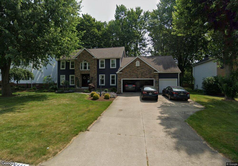
6444 Shipslanding Ave NW Canton, OH 44718
Lake Cable NeighborhoodEstimated Value: $411,000 - $471,000
4
Beds
3
Baths
2,736
Sq Ft
$157/Sq Ft
Est. Value
About This Home
This home is located at 6444 Shipslanding Ave NW, Canton, OH 44718 and is currently estimated at $429,177, approximately $156 per square foot. 6444 Shipslanding Ave NW is a home located in Stark County with nearby schools including Strausser Elementary School, Jackson Memorial Middle School, and Jackson High School.
Ownership History
Date
Name
Owned For
Owner Type
Purchase Details
Closed on
Sep 12, 2023
Sold by
Abrams Randy J and Abrams Patricia B
Bought by
Abrams Family Trust and Abrams
Current Estimated Value
Purchase Details
Closed on
Dec 18, 1996
Sold by
Mcdonald Dev Corp
Bought by
Abrams Randy J and Baumann Patricia
Home Financials for this Owner
Home Financials are based on the most recent Mortgage that was taken out on this home.
Original Mortgage
$189,800
Interest Rate
7.74%
Mortgage Type
New Conventional
Purchase Details
Closed on
Jul 10, 1996
Sold by
Laurelwoods Corp
Bought by
Mcdonald Dev Corp
Home Financials for this Owner
Home Financials are based on the most recent Mortgage that was taken out on this home.
Original Mortgage
$176,000
Interest Rate
8.09%
Mortgage Type
New Conventional
Create a Home Valuation Report for This Property
The Home Valuation Report is an in-depth analysis detailing your home's value as well as a comparison with similar homes in the area
Home Values in the Area
Average Home Value in this Area
Purchase History
| Date | Buyer | Sale Price | Title Company |
|---|---|---|---|
| Abrams Family Trust | -- | None Listed On Document | |
| Abrams Randy J | $210,900 | -- | |
| Mcdonald Dev Corp | $47,500 | -- |
Source: Public Records
Mortgage History
| Date | Status | Borrower | Loan Amount |
|---|---|---|---|
| Previous Owner | Abrams Randy J | $189,800 | |
| Previous Owner | Mcdonald Dev Corp | $176,000 |
Source: Public Records
Tax History Compared to Growth
Tax History
| Year | Tax Paid | Tax Assessment Tax Assessment Total Assessment is a certain percentage of the fair market value that is determined by local assessors to be the total taxable value of land and additions on the property. | Land | Improvement |
|---|---|---|---|---|
| 2025 | -- | $127,960 | $21,980 | $105,980 |
| 2024 | -- | $127,960 | $21,980 | $105,980 |
| 2023 | $5,268 | $104,620 | $17,990 | $86,630 |
| 2022 | $2,613 | $104,620 | $17,990 | $86,630 |
| 2021 | $5,245 | $104,620 | $17,990 | $86,630 |
| 2020 | $4,974 | $91,070 | $15,540 | $75,530 |
| 2019 | $4,792 | $91,070 | $15,540 | $75,530 |
| 2018 | $4,850 | $91,070 | $15,540 | $75,530 |
| 2017 | $4,617 | $83,020 | $14,280 | $68,740 |
| 2016 | $4,632 | $83,020 | $14,280 | $68,740 |
| 2015 | $4,701 | $83,020 | $14,280 | $68,740 |
| 2014 | $354 | $72,980 | $12,570 | $60,410 |
| 2013 | $2,139 | $72,980 | $12,570 | $60,410 |
Source: Public Records
Map
Nearby Homes
- 6513 Forestwood St NW
- 6594 Shipslanding Ave NW
- 6279 Palmer Dr NW
- 6394 Bayside St NW
- 6720 Hogan Way NW Unit 10
- 6572 Portage St NW
- 6104 Shipslanding Ave NW
- 6451 Shenandoah Ave NW
- 6311 Sorrento Ave NW
- 6257 Island Dr NW
- Lot 1 NW Lake O'Springs Ave
- 7034 Celina St NW
- 5858 Springlake Rd NW
- 5848 Portage St NW
- 6168 Coppercove Cir NW
- 5820 Kildare Cir NW
- 5691 Governors Ave NW
- 6540 Lorraine Ave NW
- 6541 Lorraine Ave NW
- 5764 Oak Dr NW
- 6460 Shipslanding Ave NW
- 6426 Shipslanding Ave NW
- 6447 Harborview Ave NW
- 6425 Harborview Ave NW
- 6410 Shipslanding Ave NW
- 6478 Shipslanding Ave NW
- 6465 Harborview Ave NW
- 6411 Harborview Ave NW
- 6483 Harborview Ave NW
- 6494 Shipslanding Ave NW
- 6392 Shipslanding Ave NW
- 6467 Shipslanding Ave NW
- 6391 Harborview Ave NW
- 6501 Harborview Ave NW
- 6543 Forestwood St NW
- 6446 Harborview Ave NW
- 6374 Shipslanding Ave NW
- 6426 Harborview Ave NW
- 6510 Shipslanding Ave NW
- 6464 Harborview Ave NW