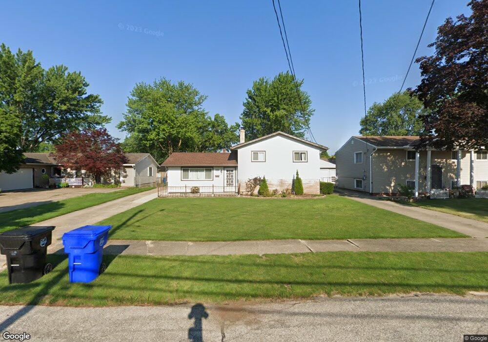
6448 Scott Dr Brookpark, OH 44142
Estimated Value: $241,000 - $272,000
4
Beds
2
Baths
2,022
Sq Ft
$128/Sq Ft
Est. Value
About This Home
This home is located at 6448 Scott Dr, Brookpark, OH 44142 and is currently estimated at $258,831, approximately $128 per square foot. 6448 Scott Dr is a home located in Cuyahoga County with nearby schools including Berea-Midpark Middle School, Berea-Midpark High School, and The Academy of St. Bartholomew.
Ownership History
Date
Name
Owned For
Owner Type
Purchase Details
Closed on
Jun 12, 2019
Sold by
Mooney Brian
Bought by
Vance Larry and Vance Jerri
Current Estimated Value
Home Financials for this Owner
Home Financials are based on the most recent Mortgage that was taken out on this home.
Original Mortgage
$100,000
Outstanding Balance
$87,746
Interest Rate
4%
Mortgage Type
Purchase Money Mortgage
Estimated Equity
$171,085
Purchase Details
Closed on
Sep 15, 2006
Sold by
Vance Jerri J and Vance Larry
Bought by
Mooney Brian
Home Financials for this Owner
Home Financials are based on the most recent Mortgage that was taken out on this home.
Original Mortgage
$130,000
Interest Rate
6.7%
Mortgage Type
Purchase Money Mortgage
Purchase Details
Closed on
Jun 3, 1992
Sold by
Papes Dale A
Bought by
Papes Jerri J
Purchase Details
Closed on
Feb 6, 1990
Sold by
Farkasovski William
Bought by
Papes Dale A
Purchase Details
Closed on
Jan 1, 1975
Bought by
Farkasovski William
Create a Home Valuation Report for This Property
The Home Valuation Report is an in-depth analysis detailing your home's value as well as a comparison with similar homes in the area
Home Values in the Area
Average Home Value in this Area
Purchase History
| Date | Buyer | Sale Price | Title Company |
|---|---|---|---|
| Vance Larry | $125,000 | Bridge Title | |
| Mooney Brian | $130,000 | Authorized Title | |
| Papes Jerri J | -- | -- | |
| Papes Dale A | $65,700 | -- | |
| Farkasovski William | -- | -- |
Source: Public Records
Mortgage History
| Date | Status | Borrower | Loan Amount |
|---|---|---|---|
| Open | Vance Larry | $100,000 | |
| Previous Owner | Mooney Brian | $130,000 |
Source: Public Records
Tax History
| Year | Tax Paid | Tax Assessment Tax Assessment Total Assessment is a certain percentage of the fair market value that is determined by local assessors to be the total taxable value of land and additions on the property. | Land | Improvement |
|---|---|---|---|---|
| 2024 | $3,684 | $73,045 | $12,075 | $60,970 |
| 2023 | $3,467 | $56,920 | $10,400 | $46,520 |
| 2022 | $3,443 | $56,910 | $10,400 | $46,520 |
| 2021 | $3,422 | $56,910 | $10,400 | $46,520 |
| 2020 | $2,915 | $42,670 | $8,260 | $34,410 |
| 2019 | $2,896 | $121,900 | $23,600 | $98,300 |
| 2018 | $2,685 | $42,670 | $8,260 | $34,410 |
| 2017 | $2,687 | $36,720 | $7,110 | $29,610 |
| 2016 | $2,665 | $36,720 | $7,110 | $29,610 |
| 2015 | $2,637 | $36,720 | $7,110 | $29,610 |
| 2014 | $2,637 | $38,640 | $7,490 | $31,150 |
Source: Public Records
Map
Nearby Homes
- 6490 Grosse Dr
- 6213 Siegler Dr
- 6572 Liberty Bell Dr Unit 23C
- 6210 Siegler Dr
- 6728 Benedict Dr
- 6040 Slater Dr
- 6748 Benedict Dr
- 6752 Benedict Dr
- 6744 Benedict Dr
- 6720 Benedict Dr
- 6724 Benedict Dr
- 6744 Fry Rd Unit 4
- 16761 Orchard Grove Dr Unit 6808A
- 6689 Fry Rd
- 16001 Sylvia Dr
- 6710 Woodruff Ct
- 16400 Heather Ln Unit 302
- 16445 Heather Ln Unit 101
- 16445 Heather Ln Unit 203
- 16475 Heather Ln Unit S202
Your Personal Tour Guide
Ask me questions while you tour the home.