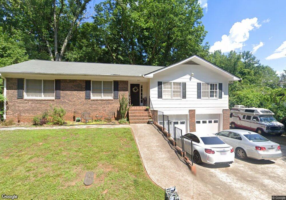
645 N Hall Rd Dahlonega, GA 30533
Estimated Value: $317,940 - $424,000
--
Bed
2
Baths
1,870
Sq Ft
$192/Sq Ft
Est. Value
About This Home
This home is located at 645 N Hall Rd, Dahlonega, GA 30533 and is currently estimated at $358,485, approximately $191 per square foot. 645 N Hall Rd is a home located in Lumpkin County with nearby schools including Clay County Middle School and Lumpkin County High School.
Ownership History
Date
Name
Owned For
Owner Type
Purchase Details
Closed on
Oct 1, 2020
Sold by
Manthei Mary C
Bought by
Manthei Mary
Current Estimated Value
Purchase Details
Closed on
Dec 13, 2013
Sold by
King Douglas N
Bought by
Manthei Mary C and Manthei Robert L
Home Financials for this Owner
Home Financials are based on the most recent Mortgage that was taken out on this home.
Original Mortgage
$127,645
Interest Rate
3.75%
Mortgage Type
FHA
Purchase Details
Closed on
Aug 11, 2005
Sold by
Lary Marilyn S
Bought by
King Douglas N and King Marguerite S
Home Financials for this Owner
Home Financials are based on the most recent Mortgage that was taken out on this home.
Original Mortgage
$116,600
Interest Rate
5.61%
Mortgage Type
New Conventional
Purchase Details
Closed on
May 31, 2000
Sold by
Murray Edward A
Bought by
Lary Marilyn S
Purchase Details
Closed on
Oct 1, 1978
Sold by
Grace E
Bought by
Murray Edward A
Create a Home Valuation Report for This Property
The Home Valuation Report is an in-depth analysis detailing your home's value as well as a comparison with similar homes in the area
Home Values in the Area
Average Home Value in this Area
Purchase History
| Date | Buyer | Sale Price | Title Company |
|---|---|---|---|
| Manthei Mary | -- | -- | |
| Manthei Mary C | $130,000 | -- | |
| King Douglas N | $145,762 | -- | |
| Lary Marilyn S | $115,000 | -- | |
| Murray Edward A | -- | -- |
Source: Public Records
Mortgage History
| Date | Status | Borrower | Loan Amount |
|---|---|---|---|
| Previous Owner | Manthei Mary C | $127,645 | |
| Previous Owner | King Douglas N | $116,600 | |
| Previous Owner | King Douglas N | $14,575 |
Source: Public Records
Tax History Compared to Growth
Tax History
| Year | Tax Paid | Tax Assessment Tax Assessment Total Assessment is a certain percentage of the fair market value that is determined by local assessors to be the total taxable value of land and additions on the property. | Land | Improvement |
|---|---|---|---|---|
| 2024 | $2,522 | $92,494 | $12,432 | $80,062 |
| 2023 | $1,946 | $87,216 | $12,432 | $74,784 |
| 2022 | $2,529 | $84,502 | $12,432 | $72,070 |
| 2021 | $2,320 | $72,782 | $12,432 | $60,350 |
| 2020 | $2,355 | $71,144 | $12,432 | $58,712 |
| 2019 | $2,367 | $71,144 | $12,432 | $58,712 |
| 2018 | $2,263 | $63,815 | $12,432 | $51,383 |
| 2017 | $2,265 | $62,832 | $12,432 | $50,400 |
| 2016 | $2,153 | $58,556 | $12,432 | $46,124 |
| 2015 | $1,628 | $58,556 | $12,432 | $46,124 |
| 2014 | $1,628 | $59,892 | $12,432 | $47,460 |
| 2013 | -- | $61,229 | $12,432 | $48,797 |
Source: Public Records
Map
Nearby Homes
- 490 N Hall Rd
- 253 Blair Ridge Rd
- 0 Dawsonville Hwy Unit 10631159
- 00 Dawsonville Hwy
- 120 Blair Ridge Rd
- 121 Blair Ridge Rd
- 399 N Chestatee St
- 549 Ivy Terrace
- 94 Mountain View Dr
- 132 J Mountain Dr
- 315 Church St
- 95 Jones St
- 168 W Main St
- 22 Honeysuckle Ln
- 114 Funaro Ln
- 0 S Chestatee St Unit 10619536
- 0 Highway 19 N Unit 10594984
- 1202 Oak Grove Rd
- 97 Beaumont Dr
- 1392 S Chestatee St