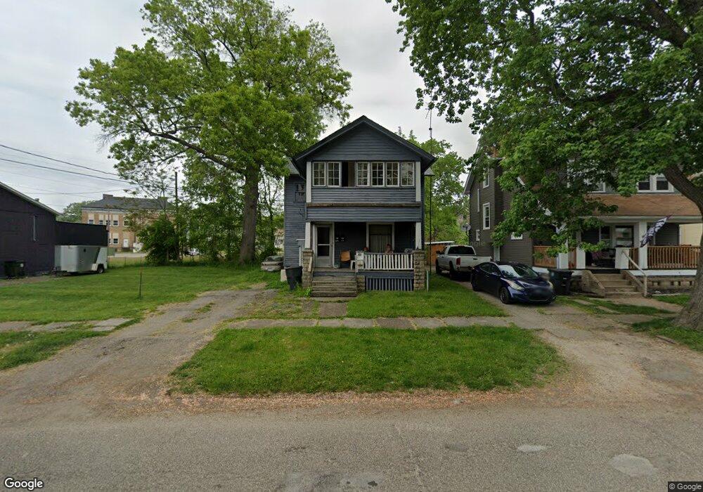
645 Porter St NE Warren, OH 44483
Central City NeighborhoodEstimated Value: $42,822
4
Beds
2
Baths
1,936
Sq Ft
$22/Sq Ft
Est. Value
About This Home
This home is located at 645 Porter St NE, Warren, OH 44483 and is currently priced at $42,822, approximately $22 per square foot. 645 Porter St NE is a home located in Trumbull County with nearby schools including Warren G. Harding High School, Willard PK-8 School, and Steam Academy of Warren.
Ownership History
Date
Name
Owned For
Owner Type
Purchase Details
Closed on
Oct 27, 2006
Sold by
Jab Investments Inc
Bought by
Gatling Sharon and Gatling Clarence
Current Estimated Value
Purchase Details
Closed on
Oct 26, 2006
Sold by
Tsamparlis Michael H and Tsamparlis Marcella
Bought by
Jab Investments Inc
Purchase Details
Closed on
Oct 25, 2006
Sold by
Jab Investments Inc
Bought by
Gatling Sharon and Gatling Clarence
Purchase Details
Closed on
Oct 17, 2006
Sold by
Tsamparlis Michael H and Tsamparlis Marcella
Bought by
Jab Investments Inc
Purchase Details
Closed on
Jan 1, 1990
Bought by
Michael Tsamparlis
Create a Home Valuation Report for This Property
The Home Valuation Report is an in-depth analysis detailing your home's value as well as a comparison with similar homes in the area
Home Values in the Area
Average Home Value in this Area
Purchase History
| Date | Buyer | Sale Price | Title Company |
|---|---|---|---|
| Gatling Sharon | $22,500 | None Available | |
| Jab Investments Inc | $14,000 | None Available | |
| Gatling Sharon | $22,500 | None Available | |
| Jab Investments Inc | $14,000 | None Available | |
| Michael Tsamparlis | -- | -- |
Source: Public Records
Tax History Compared to Growth
Tax History
| Year | Tax Paid | Tax Assessment Tax Assessment Total Assessment is a certain percentage of the fair market value that is determined by local assessors to be the total taxable value of land and additions on the property. | Land | Improvement |
|---|---|---|---|---|
| 2024 | $452 | $8,510 | $1,090 | $7,420 |
| 2023 | $430 | $8,510 | $1,090 | $7,420 |
| 2022 | $420 | $6,480 | $1,090 | $5,390 |
| 2021 | $421 | $6,480 | $1,090 | $5,390 |
| 2020 | $421 | $6,480 | $1,090 | $5,390 |
| 2019 | $427 | $6,240 | $1,090 | $5,150 |
| 2018 | $426 | $6,240 | $1,090 | $5,150 |
| 2017 | $419 | $6,240 | $1,090 | $5,150 |
| 2016 | $363 | $5,600 | $1,540 | $4,060 |
| 2015 | $361 | $5,600 | $1,540 | $4,060 |
| 2014 | $359 | $5,600 | $1,540 | $4,060 |
| 2013 | $366 | $6,020 | $1,540 | $4,480 |
Source: Public Records
Map
Nearby Homes
- 433 Olive Ave NE Unit 435
- 428 Waverly Ave NE
- 179 Logan Ave NE
- 442 Belmont Ave NE
- 563 Atlantic St NE
- 1033 Olive Ave NE
- 351 Laird Ave NE
- 257 Iddings Ave SE
- 1250 Grant St SE
- 151 Bonnie Brae Ave NE
- 356 Laird Ave SE
- 318 Fairmount Ave NE
- 855 Adams Ave NW
- 978 Hollywood St NE
- 561 South St SW
- 424 Kenilworth Ave NE
- 159 Kenilworth Ave SE
- 343 Griswold St NE
- 360 Freeman St NW
- 451 Homewood Ave SE
- 651 Porter St NE
- 661 Porter St NE
- 648 Porter St NE
- 638 Porter St NE
- 656 Porter St NE
- 626 Porter St NE
- 673 Porter St NE
- 628 Saint Clair Dr NE
- 616 Porter St NE
- 352 Elm Rd NE
- 674 Porter St NE
- 634 Saint Clair Dr NE
- 628 St Clair Ave
- 565 Thorn Ct NE
- 274 276 Elm Rd Unit 276
- 634 St Clair Ave
- 685 Porter St NE
- 573 Thorn Ct NE
- 648 Saint Clair Dr NE
- 656 Saint Clair Dr NE