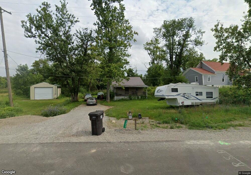
6453 Us Highway 223 Addison, MI 49220
Estimated Value: $131,783 - $319,000
2
Beds
1
Bath
988
Sq Ft
$245/Sq Ft
Est. Value
About This Home
This home is located at 6453 Us Highway 223, Addison, MI 49220 and is currently estimated at $242,446, approximately $245 per square foot. 6453 Us Highway 223 is a home located in Lenawee County with nearby schools including Addison Elementary School, Addison Middle School, and Addison High School.
Ownership History
Date
Name
Owned For
Owner Type
Purchase Details
Closed on
Jan 3, 2008
Sold by
Davis Samuel D and Davis David
Bought by
Davis Samuel D and Davis Amber J
Current Estimated Value
Home Financials for this Owner
Home Financials are based on the most recent Mortgage that was taken out on this home.
Original Mortgage
$62,000
Outstanding Balance
$38,705
Interest Rate
5.95%
Mortgage Type
New Conventional
Estimated Equity
$203,741
Purchase Details
Closed on
Oct 30, 2003
Bought by
Davis Samuel D and Davis Amber J
Create a Home Valuation Report for This Property
The Home Valuation Report is an in-depth analysis detailing your home's value as well as a comparison with similar homes in the area
Home Values in the Area
Average Home Value in this Area
Purchase History
| Date | Buyer | Sale Price | Title Company |
|---|---|---|---|
| Davis Samuel D | -- | None Available | |
| Davis Samuel D | -- | -- |
Source: Public Records
Mortgage History
| Date | Status | Borrower | Loan Amount |
|---|---|---|---|
| Open | Davis Samuel D | $62,000 |
Source: Public Records
Tax History Compared to Growth
Tax History
| Year | Tax Paid | Tax Assessment Tax Assessment Total Assessment is a certain percentage of the fair market value that is determined by local assessors to be the total taxable value of land and additions on the property. | Land | Improvement |
|---|---|---|---|---|
| 2025 | $1,224 | $38,500 | $0 | $0 |
| 2024 | $321 | $36,400 | $0 | $0 |
| 2023 | -- | $32,300 | $0 | $0 |
| 2022 | $1,119 | $29,100 | $0 | $0 |
| 2021 | $1,091 | $28,900 | $0 | $0 |
| 2020 | $1,067 | $23,900 | $0 | $0 |
| 2019 | $76,221 | $23,900 | $0 | $0 |
| 2018 | $1,162 | $39,657 | $0 | $0 |
| 2017 | $1,124 | $39,930 | $0 | $0 |
| 2016 | $1,111 | $39,169 | $0 | $0 |
| 2014 | -- | $92,963 | $0 | $0 |
Source: Public Records
Map
Nearby Homes
- 6360 Winter Rd
- 15858 Lelah Ln
- 6820 Devils Lake Hwy
- 10911 Devils Lake Hwy
- 6000 Devils Lake Hwy
- 8000 Parkhurst Hwy Unit Carroll Dr ((1175)
- 6103 Highland Ave
- 5935 Tower Dr
- 7841 Devils Lake Hwy
- Unit 3 Hollyhock Dr
- Unit 2 Hollyhock Dr
- 8484 N Rollin Hwy
- 4547 Round Lake Hwy
- 4276 Echo Cove
- 9265 Devils Lake Hwy
- 4091 Woodland Ave
- 8676 Cherry Point Dr
- 8788 Parker Hwy
- Lot 62 Pamawa Dr
- 61 Pamawa Dr
- 12000 U S 223
- 15827 Us Highway 223
- 15827 W Us 223 Hwy
- 12793 U S 223
- 12770 U S 223
- 15691 Us Highway 223
- 9000 Us Highway 223 Unit BLK
- 13005 U S 223
- 13000 U S 223
- 13030 U S 223
- 13087 U S 223
- 6545 Winter Rd
- 13131 U S 223
- 13147 U S 223
- 13151 U S 223
- 13153 U S 223
- 13195 U S 223
- 13201 U S 223
- 13257 U S 223
- 13257 U S 223 Unit 223